 Antiques (US)
Africa Maps
Asia Maps
Australia/Oceania Maps
Celestial Maps
Central America/Caribbean Maps
Curiosities Maps
Digital Maps
Europe Maps
Map & Globe Mixed Lots
Map & Globe Reproductions
North America Maps
South America Maps
World & Celestial Globes
World Maps

-
$13.95

 1661 Celestial Map of the Constellations Historic Vintage Style Map - 16x20
-
$32.50
 1941 Vintage Palestine Map Jerusalem Map Syria Lebanon Transjordan Map 1585
-
$13.95
 1876 New York City, New York Vintage Old Panoramic NY City Map - 18x24
-
$98.00
 Asia China Japan Korea India Persia Ottoman Empire Arabia Russia 1806 Tanner map
-
$298.00
 MOVA Globe 6" Earth with Clouds Satellite view Brand New
-
$2200.00
 Mitchell's National Map and Route Book S Augustus Mitchell 1846 Printer Kay and
-
$933.41
 Original 1879 London Steamboat Company Map (& Timetable)
-
$19.99
 1914 THE DELTA OF COLORADO RIVER SALTON SEA & IMPERIAL VALLEY COLOR MAP!
-
$1.99
 Map of Paris. 2018 TOURISME - TRANSPORT
-
$14.97
 Travel Map Europe Belgium Belgique Commerce Vintage Brochure Circa 1969
-
$180.46
 Rare Old Map Of Gloucestershire By Saxton’s 1577
-
$1431.23
 Original 1903 US Senate Report - Restoration of The White House - Floor Plans
-
$14.97
 Maps Salesman Sample Miniature Western Hemisphere Outlines Continental Press
-
$90.00
 دولة الامارات العربية المتحدة 1973 الإمارات الخليج UAE Emirates map خرائط خريطة
-
$68.00
 Holy Roman Empire Germany Austria Switzerland Bohemia 1815 Lattre engraved map
-
$128.99
 "Classic Elegance: Vintage Replogle World Globe on Wooden Stand"
-
$12.95
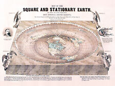 Flat Earth Map - Square and Stationary Earth Orlando Ferguson- Poster 24 x 18
-
$39.99
 Nystrom Sculptural Relief Globe Raised Terrain - 30 Centimeter / 12 Inch
-
$16.95
 North America 1771 Colonial Map - 13 Colonies - 20x24
-
$9.99
 1914 OFFICE OF INDIAN AFFAIRS FORT PECK PROJECT MONTANA MAP 9 x 12!
-
$14.95
 Flat Earth Map - Square and Stationary Earth Orlando Ferguson- Poster 24 x 18
-
$16.95
 "A Map of the United States of Mexico" 1846 Vintage Mexican Map - 20x24
-
$63.20
 ANTIQUE FRAMED CITY ILLUSTRATION CUM PRIVILEGIO ( FRAME 6.5” x 21.5” )
-
$59.99
 1914 YAKIMA INDIAN RESERVATION WASHINGTON MAPS SHOWING DAMS 4 MAPS!
-
$23.75
 Fish-n-Map Co. MILLERTON PINE FLAT LAKE AMADOR California
-
$16.95
 1835 Texas, Indian Territory & Mexican States Map Wall Map - 20x24
-
$9.99
 1914 SOUTH DAKOTA STANDING ROCK INDIAN RESERVATION SHOWING YELLOWSTONE TRAIL MAP
-
$9.99
 1914 UNITED STATES INDIAN SERVICE FLATHEAD PROJECT MONTANA MAP 8.75 x 9!
-
$55.00
 Chile Brazil Rio de Janeiro Bahia Bolivia Uruguay Paraguay 1869 Mitchell map
-
$79.99
 1879 North Central States Group US Victorian Atlas Geography 1st Edition DWAA9
-
$49.78
 1882 Map of the Mozambique coast antique vintage
-
$129.99
 1879 Trade Route Map Nautical Caravan Victorian Geography 1st Edition DWAA9
-
$22.50
 1912 Antique Arizona State Map Vintage Map of Arizona Gallery Wall Decor 1586
-
$13.95
 1530s Old Map of the World as seen from the North & South Poles - 16x24
-
$28.00
 Brand New- Miss Peregrine Book Series Map Of Devil's Acre
-
$40.00
 Table Top Mother Of Pearl World Globe
-
$85.00
 German school atlas. 115 main and secondary cards in multi-color printing
-
$16.95
 1680s Early Map of North America - New Mexico - English Empire - 20x24
-
$49.78
 1882 general and route Map of the Makua country Mozambique antique vintage
-
$174.49
 MCM 1964 Vintage Masketeers 1628 World Map Brass and Wood Wall Metal Art 44 x 30
-
$5.99
 Taiwan the Heart of Asia Tourist Map
-
$48.88
 Old 1909 Plat Map ~ AMBOY Twp., COTTONWOOD Co., MINNESOTA ~Free S&H
-
$12.00
 DUBLIN plan 1894 IRELAND ORIGINAL Map Baile Átha Cliath Éire
-
$198.00
 MOVA RELIEF MAP BLUE GLOBE 4.5 Inch Solar Power
-
$89.95
 1851 antique Dr BUTLER'S ATLAS of ANCIENT GEOGRAPHY antient MAPS
-
$30.00
 1837 Map of Pittsylvania County, Virginia - Educational Poster (18x24in)
-
$13.95
1846 Map of the United States of Mexico - American Southwest Map - 16x20
-
$24.88
 National Geographic Map - West Indies and Central America - 1970 - Vintage
-
$19.99
 Vintage Old World Globe Zodiac Astrology Zona Signs Wood & Leather Made in Italy
-
$70.00
 Mars Globe - 12-inch
-
$9.99
 1914 DEPT OF THE INTERIOR OFFICE OF INDIAN AFFAIRS BLACKFEET PROJECT MONTANA MAP
-
$75.00
 1812 Lapie Map of Great Britian Scotland and Ireland
-
$150.00
 Atlas General 1873
-
$35.05
 Globo Terraqueo de 6.5 Pulgadas con Soporte Globo Educativo Pequeno Aprendizaje
-
$16.95
 "The New World" 1562 Historic Exploration Map - 20x24
-
$29.00
 Antique Vintage Zodiac Brass Armillary Sphere with Wooden Base 5 Inch, Gift Item
-
$217.80
 ORIGINAL ANTIQUE MAP "SUFFOLK", by ROBERT MORDEN 1695 SUPERB FRAMED AND GLAZED
-
$12.95
 Vintage EUROPE Map Wall Art Decor Old Original 1940s WWII Era Antique
-
$28.99
 Map of Armenia and Artsakh Nagorno Karabakh in English and Armenian Հայաստան Արց
-
$25.00
 1895 Kraków Cracow Original city plan map Poland 19th Century Krakow
-
$16.95
 1940s Vintage California Picture Map Antique California State Map Wall Art 1563
-
$18.95
 1940 Vintage Italy Map Gallery Wall Decor Antique Atlas Map of Italy 1584
-
$17.95
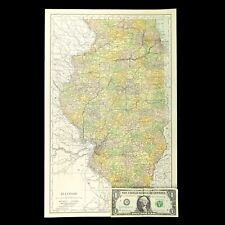
 1941 Vintage ILLINOIS Map Antique State Map of Illinois Atlas Map Decor 1583
-
$11.86
 1917 Vintage CLEVELAND Map City Street Old Original Cleveland Ohio Antique Road
-
$31.10
 National Geographic Map - Africa - 1943 - Vintage
-
$27.50
 1943 Vintage MANHATTAN City MAP New York City & The Bronx Map Set of 2 Maps 1258
-
$16.95
 1940s Vintage Wisconsin Picture Map Wisconsin State Map Wall Art Decor 1565
-
$25.00
 The Spokane Valley WA - Rathdrum Prarie ID Aquifer Atlas / Map - 5th Edition NEW
-
$49.77
 National Geographic Map - Africa - 1935 - with Index Booklet - Vintage
-
$149.99
 1879 Railroad Map US Industrial Commercial Victorian Geography 1st Edition DWAA9
-
$34.37
 Globe U01494
-
$79.99
 1879 Map Europe Western And Central Victorian Geography 1st Edition DWAA9
-
$16.95
 Historic Map of New England 1747 Vintage Style Colonial Map - 20x24
-
$79.99
 1879 Map West Central States Group Victorian Atlas Geography 1st Edition DWAA9
-
$79.99
 1879 Political Map Europe And Western Asia Victorian Geography 1st Edition DWAA9
-
$79.99
 1879 Political Map Of Asia Victorian Atlas Harpers Geography 1st Edition DWAA9
-
$79.99
 1879 Map Connecticut United States Victorian Atlas Geography 1st Edition DWAA9
-
$124.95
 1836 antique PARIS folding MAP nouveau plan routico ville de paris chez rosselin
-
$16.96
 Vintage ILLINOIS Map Railroad Wall Art Old Original Electric Rail Lines
-
$25.95
 Colton's 1861 Map of the State of North Carolina - 24x36
-
$9.94
 Fold Up 1930 Advertising Map - Jersey - Channel Island - VGC
-
$13.95
 1720 Old World Exploration Map Historic Print - 16x24
-
$79.99
 1879 Map Asia Desert Arctic Peninsula Belt Victorian Geography 1st Edition DWAA9
-
$79.99
 1879 Map British Isles England Scotland Victorian Geography 1st Edition DWAA9
-
$19.99
 United States Hammond Map
-
$16.95
 1747 Map of the Gulf Coast - Louisiana to Florida - 20x24
-
$345.00
 antique UTICA NY ATLAS MAPS in 1899 sanborn ferris 1906-22 index 25.5x23" 116pg
-
$79.99
 1879 Map Europe Spain France Italy England Victorian Geography 1st Edition DWAA9
-
$19.50
 1941 Antique Europe Map Vintage Atlas Map of Europe Gallery Wall Decor 1580
-
$304.91
 Map "Carte de la Nouvelle Angleterre, Nouvelle York et Pensilvanie" Bellin,c1750
-
$79.99
 1879 Map South Central Atlantic US Victorian Harpers Geography 1st Edition DWAA9
-
$79.99
 1879 Political Map South America Victorian Harpers Geography 1st Edition DWAA9
-
$79.99
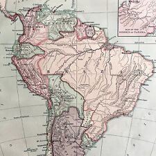
 1879 Map Of South America Brazil Victorian Geography 1st Edition DWAA9
-
$79.99
 1879 Map US Mid Atlantic States Victorian Harpers Geography 1st Edition DWAA9
-
$13.95
 1898 Goffs Map of the Spanish American War Carribean - 16x24
-
$9.56
 Vintage Belgium Map by Budget European stmap Abz
-
$13.95
 1650s “Insulae Americanae” Vintage Style US Caribbean Map - 18x24
-
$13.95
 Bird's Eye View 1851 New Orleans Louisiana Vintage Style City Map - 18x24
-
$74.67
 1882 Map of the Rovuma River Tanzania Mozambique antique vintage
-
$49.78
 1882 Map of the Nguru mountain district Tanzania coast antique vintage


