 Antiques (US)
-
$35.68

 antique Tombleson's map of river Thames with 9 inset views 1850 art print poster
-
$43.50
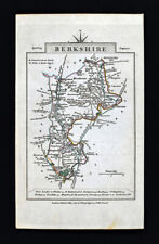
 1830 Berkshire Map by Hoare & Reeves Large Antique Hand Coloured Map
-
$55.95
 100% ORIGINAL ESSEX FOX HUNTING MAP BY HOBSON C1860/S VGC COLOURED
-
$23.50
 River Thames antique Victorian excursions guide map Eton to Nore 1849 art poster
-
$53.00
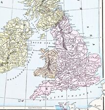 1898 British Isles Historical Map England Ireland Scotland Wales London
-
$8.08
 1902 Map of Oxford Essex Sussex Surrey antique vintage Britannica 10th
-
$38.88
 1897 England Map London Ramsgate Oxford Buckingham Reading Hampstead Richmond
-
$38.00
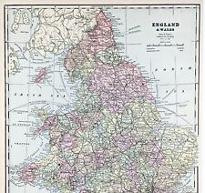 ENGLAND WALES Map 1889 ORIGINAL London Dover Railways Counties Townships G. CRAM
-
$39.95
 Vintage framed Hand Stitched Map Of England And Wales 20.5" x 16.5"
-
$38.88
 1889 Switzerland Map ORIGINAL Zurich Geneva Bern Cantons Townships Railroads
-
$22.00
 Somerset, Wiltshire, Berkshire & Hampshire - Original 1922 Ordnance Survey Map
-
$7.46
 1720 Antique Road Map Maidenhead Henley Dorchester Abingdon ex-Britannia Depicta
-
$68.38
 1610 (1650) Antique Map: Dorset Miniature Speed / van den Keere
-
$24.85
 1895 Berkshire Original Antique County Map by G.W. Bacon
-
$111.89
 RARE Antique Map , W Pinnock , 1832 , , England , Berkshire
-
$412.50
 1662 Joan Blaeu Antique Map of the English County of Berkshire
-
$14.09
 1895 Berkshire antique map. Newbury, Reading, Windsor. 129 years old. Victorian.
-
$23.99
 1831 Lewis Map Berkshire Windsor Maidenhead Abingdon Oxford Newbury England UK
-
$11.19
 County map of Berkshire England hand coloured c1860
-
$19.99
 1831 Lewis Map Bedfordshire Bedford Luton Shefford Ampthill Dunstable England UK
-
$25.49
 River Thames Old London Bridge Elizabethan view map Merian 1638 art poster print
-
$149.20
 HAMPSHIRE NORTH BY WILLIAM MUDGE c1817 GENUINE 1st EDITION ORDNANCE SURVEY MAP
-
$19.99
 1831 Lewis Map Berkshire Windsor Maidenhead Reading Oxford Newbury England UK
-
$28.00
 1830 Nathan Hale Map England Wales London Liverpool Oxford Cornwall Bristol UK
-
$49.73
 Antique map of Berkshire by Richard Blome 1715
-
$15.52
 1855 BERKSHIRE antique map by J Archer. 167 years old. Reading, Wantage.
-
$62.17
 OXFORD TO CHICHESTER BY JOHN OGILBY REDUCED BY THOMAS GARDNER c1719
-
$40.47
 Berkshire map by Eman Bowen copper engraved & colour 1853
-
$24.85
 1863 Berkshire Original Antique Hand Coloured Weekly Dispatch Map
-
$49.67
 100% ORIGINAL WILTSHIRE FOX HUNTING MAP BY HOBSON C1860/S VGC COLOURED
-
$68.38
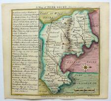
 100% ORIGINAL BERKSHIRE MAP BY BUTTERS C1805 VGC SCARCE HAND COLOURED
-
$24.85
 1884 Berkshire Original Antique Coloured County Map by Letts
-
$31.99
 1814 John Cary Road Map Berkshire Windsor Park Reading Oxford Newbury England UK
-
$10.00
 ELGAR'S BELOVED COUNTRY Booklet - By Michael Grundy - Elgar Route122523
-
$25.16
 Vintage 1900 IRELAND Map 11"x14" ~ Old Antique Original DONEGAL DUBLIN GALWAY
-
$4.97
 BERKSHIRE antique county map by GW BACON 1898 old plan chart
-
$14.92
 Vintage Berkshire Map Bacons Geographical Establishment 50cm x 34cm (M)
-
$14.91
 Reading town plan from the Ordnance Survey. Berkshire. Sketch map 1885 old
-
$22.37
 1720 Abingdon - Fairford Gloucester - Monmouth Antique Road Map by Emanuel Bowen
-
$35.68
 antique Londinium Londinum Elizabethan London map Agas Wallis 1563 poster print
-
$62.17
 OXFORD TO SALISBURY & POOLE BY JOHN OGILBY REDUCED BY THOMAS GARDNER c1719
-
$14.09
 1896 Wiltshire, Hampshire & West Berkshire. Victorian county map.
-
$49.72
 BERKSHIRE BY BADESLADE & TOMS c1742 ORIGINAL HAND COLOUR GENUINE ANTIQUE MAP
-
$43.52
 TAPLOW, MAIDENHEAD, KNOWL HILL, RUSCOMBE, SONNING original antique map MOGG 1817
-
$55.95
 1840 ANTIQUE ORDNANCE SURVEY MAP BERKSHIRE - ORIGINAL SERIES ONE INCH SHEET 13
-
$15.54
 Bacon's Large-Print Motor Map of South Central England
-
$35.68
 antique Tombleson's Panoramic map of river Thames & Medway 1850 art print poster
-
$43.52
 READING, CALCOT, ENGLEFIELD, WOOLHAMPTON, MIDGHAM original antique map MOGG 1817
-
$12.42
 Vintage decorative sheet map of Barkshire Berkshire Windsor John Speede 1610
-
$8.69
 Salisbury Plain Vintage Old Revised Half Inch Bartholomews Map 1937 Reading
-
$4.97
 WINDSOR CASTLE. Vintage map plan. Berkshire 1930 old vintage chart
-
$37.30
 Berkshire map by John Aikin England Delineated Original with text 1803
-
$68.38
 OXFORD TO BRISTOL ROAD MAP BY JOHN OGILBY REDUCED BY THOMAS GARDNER c1719
-
$4.97
 WINDSOR CASTLE. Vintage ground plan. Berkshire 1951 old vintage map chart
-
$12.42
 OLD COPY OF JOHN SPEED MAP OF BERKSHIRE WINDSOR CASTLE 1610
-
$31.07
 GLOUCESTER ABINGDON FAIRFORD LECHLADE BY EMANUEL BOWEN c1720 GENUINE ANTIQUE MAP
-
$15.70
 1908 antique Berkshire/Hampshire/Surrey road map. Windsor, Reading & Guildford.
-
$82.06
 River Thames Burcott Little Wittenham Dorchester Shillingford Henry Taunt 1885
-
$7.15
 Salisbury Plain Vintage Old Revised Half Inch Bartholomews Map 1955 Reading
-
$21.14
 Original antique road map, Oxfordshire, Berkshire, Farringdon, Paterson 1785
-
$19.99
 ANTIQUE 1775 BERKSHIRE ABINGTON MONMOUTH LONDON ENGLAND COPPERPLATE ROAD MAP NR
-
$99.46
 1785 Berkshire antique map hand-coloured & framed Bowles's New Medium Map
-
$15.70
 1908 antique Wiltshire/Berkshire road map. Marlborough, Swindon, Newbury.
-
$62.17
 LONDON TO ST DAVIDS ROAD MAP BY JOHN OGILBY REDUCED BY THOMAS GARDNER c1719
-
$74.60
 LONDON TO HOLYHEAD ROAD MAP BY JOHN OGILBY REDUCED BY THOMAS GARDNER c1719
-
$23.00
 ABINGDON, LECHLADE-ON-THAMES, GLOUCESTER, original antique road map, Bowen, 1759
-
$292.19
 BERKSHIRE, Saxton & Hole, Camden original antique map 1637
-
$11.18
 SALISBURY WINCHESTER READING No 33 CLOTH Ordnance Survey Map Half Inch 1901 1926
-
$18.64
 BERKSHIRE WINDSOR MINIATURE MAP BY JOHN CARY c1828 GENUINE ANTIQUE
-
$31.08
 Original antique road map BERKSHIRE, OXFORDSHIRE, WORCESTERSHIRE, Laurie, 1823
-
$37.29
 BERKSHIRE BY SELLER / GROSE c1787 GENUINE ANTIQUE COPPER ENGRAVED MAP
-
$6.20
 Old Tudor map of Berkshire, England: Windsor Castle: John Speed 1600's Reprint
-
$23.59
 1921 Antique Denmark with Schleswig-Holstein and Iceland Bornholm Map
-
$22.38
 Somerset Wiltshire Berkshire Hampshire Salisbury Plain. ORDNANCE SURVEY 1922 map
-
$93.25
 1610 (1650) Antique Map: Berkshire Miniature Speed / van den Keere
-
$86.97
 Original 1919 OS Sheet Egham Callowhill Englefield Green Virginia Water Windsor
-
$82.06
 map River Thames Purley and Mapledurham to Caversham and Reading by Taunt 1885
-
$82.06
 River Thames map North Stoke Little Stoke Moulsford South Stoke by Taunt 1885
-
$11.69
 1890s HORNE'S TOURIST MAP of WHITBY & NEIGHBOURHOOD (UK) On Cloth
-
$47.25
 READING, BERKSHIRE, Original Street Plan, Dawson Original antique map 1832
-
$80.00
 Antique Thomas Moule Color Berkshires Abingdon Windsor Old Map Framed Hanging
-
$19.89
 OLD ANTIQUE MAP BERKSHIRE c1812 ENGRAVING by J WALLIS ORIGINAL HAND COLOUR
-
$87.02
 Genuine Georgian Antique Map of Berkshire by C Smith, 1804 with slip case
-
$12.42
 1787 Antique Map; Berkshire by Grose
-
$18.59
 1898 Wiltshire, Berkshire & Gloucestershire large map. 125 years old. Bristol.
-
$17.93
 Antique 1897 South East & Central England large map. 125 yrs old. London, Oxford
-
$74.60
 LONDON TO ST DAVIDS ROAD MAP BY JOHN OGILBY REDUCED BY THOMAS GARDNER c1719
-
$12.42
 Old Tudor Poster map of Berkshire, Windsor Speed 1600's 15" x 12 Reprint Antique
-
$24.85
 WILTSHIRE BERKSHIRE GLOUCESTER BRISTOL BY PATERSON c1785 GENUINE ANTIQUE MAP
-
$104.44
 River Thames map Shepperton via Walton on Thames and Sunbury Taunt 1885
-
$22.38
 Environs of Oxford Map on Cloth W.H. Smith Reduced Maps for Tourists c.1910s
-
$62.16
 Framed engraving vintage Map Part Of Suffolk part of Cambridge colourful map
-
$47.25
 WINDSOR, BERKSHIRE, ENGLAND Street Plan, Dawson Original antique map 1832
-
$37.29
 Saxton's Map Oxfordshire Bucks Berkshire 1574 50x 61cm 1968 British Museum maps
-
$180.29
 BERKSHIRE BY BLOME / HOLLAR c1673 GENUINE ANTIQUE COPPER ENGRAVED MAP
-
$43.50
 1701 (1720) Antique Morden Map Berkshire - from new Description & State England
-
$98.22
 Henley to Wargrave and Shiplake Lock River Thames c1885 map Taunt
-
$15.54
 Dugdale & Neele 1819 Antique Map. Berkshire
-
$24.87
 1794 Berkshire Original Antique Map by Thomas Bowen
-
$404.09
 100% ORIGINAL LARGE HAMPSHIRE BERKSHIRE MAP BY JANSSON C1650 VGC HAND COLOURED


