 Antiques (US)
-
$180.42

 VINTAGE GEOGRAPHIA 1950s SCHOOL EDUCATIONAL GLASGOW STREET PLAN WALL MAP PRE M8!
-
$14.99
 Map European Union 2013 États Membres De L’union Européenne Poster 21x20 Inch
-
$6.21
 Ordnance Survey Map Landranger Series 128 Derby & Burton upon Trent Area
-
$155.53
 VINTAGE W AK JOHNSTON 1950s SCHOOL EDUCATIONAL ENGLAND & WALES COUNTIES WALL MAP
-
$35.00
 MAP OF OLD ROME ROMA ITALY ENGRAVING PRINT ITALIAN ART GIAMBATTISTA NOLLI NEW!
-
$9.97
 Pair of Amsterdam Popout Maps - Brand New
-
$49.00
 Original 16th Century Franz Hogenberg Etching / print ~ Military Battle Scene
-
$3.95
 Map CASPIAN SEA National Geographic Magazine 1999 Sea Between Iran and Russia
-
$29.99
 Map of 1748 Roma Rome Italy Engraving Print Artwork Nice Detail 25.5"x30.5"
-
$11.19
 Maps Of France 3 Avignon Montpellier Auvergne Pays Du Nord Picardie Tourist Maps
-
$11.19
 Denbigh Vintage Ordnance Survey Map 1961 Large Fold Out North East Of Wales
-
$16.80
 VINTAGE MAP OF WILTSHIRE (REPRODUCTION) JOHN SPEED 1600s STONEHENGE 57 x 44.5cm
-
$19.95
 GREECE - GRECE - GRIECHENLAND - Map- Marco Polo - 1 inch = 12.6 miles
-
$6.21
 Ordnance Survey Map Landranger Series 146 Lampeter & Llandovery Area
-
$6.21
 Ordnance Survey Map Landranger Series No.185 Winchester & Basingstoke Area
-
$6.21
 Ordnance Survey Map Landranger Series No.186 Aldershot, Guildford & Area
-
$9.94
 West Devon Ordnance Survey Map SW Roadford Lake Broadwoodwidger Large 1992 SX49
-
$12.43
 OLD COPY OF JOHN SPEED MAP OF WILSHIRE WILTSHIRE STONE HENGE SALISBURY TOWN PLAN
-
$9.94
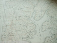
 Devon Ordnance Survey Map Large 1992 SX49 NW Halwill Witherdon Wood Upcott
-
$39.80
 Northamptonshire map John Speed 1685 reproduction framed 57x48cm
-
$12.43
 OLD COPY OF MAP MARINE CHART OF THE ENGLISH CHANNEL 1700'S
-
$1.85
 dunas maspalomas official gay guide promo. plan before you go. Nov 2023 - Jan 24
-
$16.16
 Admiralty Chart Map Da Buonfornello A Castel Di Tusa Italy Italian Nautical Map
-
$381.19
 John Richard 17th Century Caernarvon Decorative Reproduction Framed Map Exclent
-
$7.40
 Old Ordnance Survey Maps Acock's Green & South Yardley Warwickshire 1913
-
$12.43
 Iceland, Reproduction Of Tabula Islandiae, Flandro, Blaeuw, Hotel Holt Menu
-
$750.00
 Daciarum Moesiarum , anno 1603, Ortelius Abraham map, contemporary colours
-
$4.96
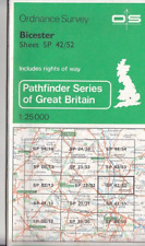 Ordnance Survey (OS) Map 1:25,000 Pathfinder Sheet SP 42/52 Bicester
-
$6.83
 Ordnance Survey Outdoor Leisure Map No.28 Dartmoor (2)
-
$6.21
 Ordnance Survey Map Landranger Series No.140 Leicester & Coventry Area
-
$6.83
 Ordnance Survey Outdoor Leisure Map No.17 Snowdon Area
-
$16.91
 Vintage Large Pullout Map To Walsall The Black Country
-
$435.49
 ATLAS OF THE WORLD/ATLAS ŚWIATA/- BY TOPOGRAPHIC SERVICE OF THE POLISH ARMY-1962
-
$1.24
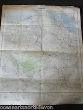
 1992 low fly Map of Norway coast
-
$14.93
 London Underground tube map - 1911, 10x8 print
-
$12.43
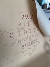 Old map Of croydon - 1847
-
$435.49
 NARODOWY ATLAS POLSKI/NATIONAL ATLAS OF POLAND/- BY POLISH ACADEMY OF SCIENCE
-
$37.32
 Reproduction Framed Sussex Map - John NORDEN & William KIP - 11 X 17 IN
-
$4.34
 Ordnance Survey Map Landranger Series Sheet No 118 Derby & Burton upon Trent
-
$6.83
 Ordnance Survey Outdoor Leisure Map No.7 The English Lakes North East Area
-
$6.22
 DECORATIVE BOOK PLATE PRINT REPRODUCTION MAP HAMBURG & RIVER ELBE GERMANY 1630
-
$41.06
 Antique Print (1880) - Contemporary Map West Indies & Central America
-
$4.34
 Ordnance Survey Map 1:25000 Pathfinder Sheet SP 03/13 Broadway, Chipping Campden
-
$3.72
 Bartholomew 1:100,000 National Map Series 14: Oxford
-
$3.72
 Bartholomew 1:100,000 National Map Series 19: Birmingham & Northampton
-
$3.72
 Bartholomew 1:100,000 National Map Series 34: The Lake District
-
$7.40
 OLD ORDNANCE SURVEY MAP CAMBRIDGE (NORTH) 1901
-
$10.58
 Vintage Greece Map With City Plans Athens & Thessalonica 1969 Folding Paper
-
$5.06
 1985 Russian Travel Brochure with maps of Ryazan Region and Ryazan-City
-
$7.40
 Old Ordnance Survey Map Warrington 1893 Lancashire Sheet 116.01a
-
$4.96
 Ordnance Survey Map 1:25,000 Pathfinder Sheet TQ 23/33 Crawley
-
$4.96
 Ordnance Survey (OS) Map 1:25,000 Pathfinder Sheet SO 80/90 Stroud
-
$4.34
 Ordnance Survey (OS) Map 1:25,000 Pathfinder Sheet SO 63/73 Ledbury, Much Marcle
-
$12.43
 PHILIP'S FRANCE AND BELGIUM FOLDING & Germany Netherlands Road Maps Index & Plan
-
$3.72
 Bartholomew 1:100,000 National Map Series 9: London & Surrey
-
$9.94
 West Devon Ordnance Survey Map NE Beaworthy Northlew South West Large 1992 SX49
-
$4.34
 Ordnance Survey (OS) Map 1:25,000 Pathfinder Sheet SK 63/73 Radcliffe on Trent
-
$700.00
 Romaniae/Bulgariae/map, anno 1584, Ortelius, contemporary colours, ORIGINAL
-
$4.34
 Ordnance Survey (OS) Map 1:25,000 Pathfinder Sheet SE 06/16 Grassington, Pateley
-
$31.09
 STANFORD 1998 ERA 1/25000 LARGE MAP CHART FOLDED LIGHT WEAR NORFOLK -
-
$34.97
 Original MAP: THUN SWITZERLAND 1936,
-
$4.96
 Ordnance Survey (OS) Map 1:25,000 Pathfinder Sheet SO 80/90 Stroud
-
$41.06
 Antique Print (1880) - Contemporary Map Austria
-
$31.09
 STANFORD 1998 ERA 1/25000 LARGE MAP CHART FOLDED LIGHT WEAR NORFOLK
-
$4.96
 Ordnance Survey (OS) Map 1:25,000 Pathfinder SS 83/93 Exford & Brendon Hills (W)
-
$41.06
 Antique Print (1880) - Contemporary Map South America
-
$4.96
 Ordnance Survey (OS) Map 1:25,000 Pathfinder Sheet SJ 02/12 Tanat Valley
-
$4.34
 Ordnance Survey (OS) Map 1:25,000 Pathfinder Sheet SK 21/31 Ashby-de-la-Zouch
-
$4.96
 Ordnance Survey (OS) Map 1:25,000 Pathfinder Sheet SP 04/14 Vale of Evesham
-
$4.96
 Ordnance Survey (OS) Map 1:25,000 Pathfinder Sheet SO 80/90 Stroud
-
$4.96
 Ordnance Survey (OS) Map 1:25,000 Pathfinder SP 01/11 Northleach & Andoversford
-
$600.00
 Frankfurt/M., Braun/Hogenberg, Teil I, 1572, lat., RARA-etching, original
-
$4.96
 Ordnance Survey (OS) Map 1:25,000 Pathfinder Sheet SK 03/13 Uttoxeter
-
$41.06
 Antique Print (1880) - Contemporary Map Asia
-
$41.06
 Antique Print (1880) - Contemporary Map France In Departments
-
$31.11
 Collection of 22 Ordnance Survey Explorer Maps including Outdoor Leisure
-
$850.00
 Siciliae, anno 1747, Homann Heirs, CONTEMPORARY COLOURS Regni & Insulae Siciliae
-
$41.06
 Antique Print (1880) - Contemporary Map Russia
-
$41.06
 Antique Print (1880) - Contemporary Map Europe
-
$3.72
 Bartholomew 1:100,000 National Map Series 15: Herts & Bucks
-
$41.06
 Antique Print (1880) - Contemporary Map Victoria New South Wales & S Australia
-
$4.96
 Ordnance Survey 1:25,000 Outdoor Leisure Map 7 English Lakes South Eastern Area
-
$3.72
 Bartholomew 1:100,000 National Map Series 41: The Borders
-
$41.06
 Antique Print (1880) - Contemporary Map India
-
$7.40
 MAP OF BIRTLEY 1895 (REVISED EDITION)
-
$3.72
 Bartholomew 1:100,000 National Map Series 55: Inverness & Moray Firth
-
$41.06
 Antique Print (1880) - Contemporary Map Turkey In Asia
-
$12.00
 Tartan Map Of Scotland
-
$6.22
 DECORATIVE BOOK PLATE PRINT REPRODUCTION MAP FRANCE 1627 JOHN SPEED
-
$6.22
 DECORATIVE BOOK PLATE PRINT REPRODUCTION MAP CITY FRANKFURT GERMANY 1572
-
$6.21
 Decorative County Map Of Monmouthshire By Thomas Moule 1830, Chepstow Castle
-
$3.72
 SKIPTON first edition c1843 one inch Ordnance Survey reprint map
-
$6.21
 Ordnance Survey Map Landranger Series Denbigh & Colwyn Bay Area Sheet No.116
-
$7.47
 Worcester Map Fast Find
-
$4.96
 Ordnance Survey Map 1:25000 Pathfinder Sheet SX 69/79 Belstone & Cheriton Bishop
-
$6.21
 Ordnance Survey Landranger Map No.110 Sheffield & Huddersfield Area 1:25,000
-
$6.21
 Ordnance Survey Map Landranger Series sheet 180 Barnstaple & Ilfracombe area (1)
-
$6.83
 Ordnance Survey Map Landranger Series Weston-super-Mare area Sheet No.182
-
$7.45
 Ordnance Survey Outdoor Leisure Map No.28 Dartmoor (1)
-
$12.43
 LANCASHIRE Map - Sheet SD 83 - 1954 Ordnance Survey Map


