 Antiques (US)
-
$299.99

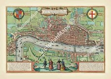
 AUTHENTIC LARGE COLOR MAP FROM 18TH CENTURY - Museum Grade Quality
-
$50.36
 Vintage 1887 LONDON ENGLAND Map 21"x13" ~ Old Antique Original KENSINGTON PARK
-
$41.72
 Vintage 1901 LONDON ENGLAND UK Map 11"x14" ~ Old Antique Original REGENTS PARK
-
$46.76
 Vintage 1892 LONDON ENGLAND Map 22"x14" Old Antique Original HYDE PARK
-
$28.88
 1855 Great Britain Map ORIGINAL England Ireland Scotland Wales London Dublin
-
$23.98
 Vintage 1920 Ireland Map Connaught Galway London Edinburgh Dublin City Insets
-
$16.16
 1888 Tiny Antique England Map Miniature Vintage Map of England 785
-
$39.56
 Vintage 1904 LONDON ENGLAND Map 11"x14" ~ Old Antique Original BATTERSEA CHELSEA
-
$28.88
 OLD 1899 Southern England Wales Map London Cornwall STEAMSHIPS RAILWAYS PORTS
-
$49.99
 5 Antique 1920’s/1940's LONDON ENGLAND MAPS/GUIDE BOOKS/ATLAS Paper/Cloth Travel
-
$50.36
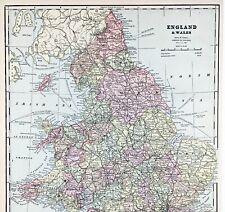
 Vintage 1900 ENGLAND & WALES Map 14"x22" Old Antique Original BRITAIN UK LONDON
-
$28.30
 1894 ORIGINAL ANTIQUE MAP OF LONDON ZOO / LONDON ZOOLOGICAL GARDENS
-
$28.76
 Vintage 1901 ENGLAND & WALES UK Map 14"x22" Old Antique Original LONDON CARDIFF
-
$35.99
 Vintage 1902 LONDON ENGLAND Map 11"x14" ~ Old Antique Original KENSINGTON PALACE
-
$39.96
 Geological Map Of The British Islands 4th Edition Sir William Pugh 32” x 25”
-
$23.50
 antique Elizabethan Tudor FIRST MAP OF LONDON Braun & Hogenberg 1572 art poster
-
$70.00
 Eighteenth Century Hand-Col. Map of London & Environs, 1787 - PRICE REDUCED
-
$28.88
 OLD 1853 ENGLAND IRELAND Map ORIGINAL Wales Scotland London Dublin Glasgow
-
$25.00
 Bartholomews Historical Map Of London Cloth + Geographia LONDON Street Plan
-
$40.00
 Enlarged Pictorial Plan of London Foldout Map. Chas. Baker & Co. c.1912
-
$23.76
 1939 VINTAGE MAP OF EASTERN MEDITERRANEAN SEA GREECE TURKEY ARMENIA / CYPRUS
-
$74.60
 London The TOWER Liberty. Original engraving by Blome ca 1720
-
$24.99
 Original 1882 Bartholomew Map CENTRAL LONDON Tower Subway England Westminster
-
$22.57
 1888 ORIGINAL ANTIQUE MAP OF SOUTHERN ENGLAND AND WALES / LONDON CORNWALL
-
$20.19
 1921 ANTIQUE MAP OF SOUTHERN ENGLAND LONDON ESSEX KENT SURREY VERSO / SCOTLAND
-
$28.04
 Vintage 1901 ENGLAND & WALES Map 14"x22" Old Antique Original CARDIFF LONDON
-
$23.90
 1877 London United Kingdom - Vintage City Map ORIGINAL 11.5 x 9.5" - C12-9
-
$21.19
 Vintage Tourist Map of Great Britain and Northern Ireland United Kingdom 1960
-
$165.00
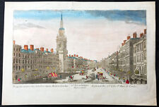 1760 Vue D Optic Large Antique Print View of Cheapside, London St Mary le Bow
-
$249.50
 Antique Map-South England and counties-London-Sussex-Kent-Wales-Sanson-ca. 1720
-
$937.50
 Map of London 14 Miles round St Pauls original Pigot c1832 Antique RARE Framed
-
$24.75
 1919 Antique London England City Map Street Map of London Wall Art 1234
-
$38.88
 1898 British Islands ENGALND Map Anglo-Saxon and Celtic Kingdom Ireland Scotland
-
$40.00
 1756 "The London Magazine" - Kitchin Map of Anglesey - Christopher Wren -Minorca
-
$43.52
 Bacon's New Large Print Map of London and Suburbs - Circa 1914
-
$11.19
 1909 Map of London West End from Hyde Park and Belgravia to the Thames vintage
-
$12.99
 Original 1882 Map LONDON England Marylebone Greenwich Hackney Southwark Finsbury
-
$14.99
 Original 1902 Map VICINITY OF LONDON England Oxford Cambridge Suffolk Railroads
-
$250.00
 1857 Huge 4-Panel Color Map . ENGLAND & WALES . Stanford - Original Antique Rare
-
$31.07
 1907 Railway Map Of London Overground & Underground by George Philip
-
$48.88
 1899 London ENGLAND Map ORIGINAL River Thames Ipswich RAILROADS Battlefields
-
$24.99
 1882 Antique COLOR Map / CITY OF LONDON, ENGLAND
-
$18.65
 1909 Railway Trams Underground Map of London vintage antique plan Baedeker
-
$11.19
 1909 Map of London The City from St Paul's to the Tower vintage antique Baedeker
-
$6.22
 Brtholomew's Street Index Plan of London - North-East Section c1930
-
$87.03
 British Isles map Mercator Hondius Jansson edition Original Anglia 1634
-
$9.99
 1892 Crowell Kirkpatrick Map - England & Wales London Liverpool Bristol Cornwall
-
$22.00
 London England & Vicinity - Original 1908 Map by Meyers. Antique
-
$28.00
 1890 Saxon Medieval England Scotland Map London Hadrian's Wall Picts Shetland
-
$15.00
 Cook’s Handbook To London - 1926.
-
$11.20
 1937 McNally Map British Isles Great Britain & Ireland England Scotland London
-
$53.46
 CITY OF LONDON - JOHN EVELYN'S PLAN FOR REBUILDING THE CITY OF LONDON AFTER 1666
-
$12.42
 Antique 1960s London Map - Mounted - HARROW & WEALDSTONE, HEADSTONE
-
$29.47
 antique guide map early plan of London Westminster Bowles 1800 art print poster
-
$8.08
 Western Super Mare Ordnance Survey Linen Map Special Sheet 1928 Ellis Martin Cov
-
$74.60
 London St Andrews Holborn Parish Original engraving by Blome ca 1720
-
$38.00
 ENGLAND WALES Map 1889 ORIGINAL London Dover Railways Counties Townships G. CRAM
-
$39.95
 Vintage framed Hand Stitched Map Of England And Wales 20.5" x 16.5"
-
$37.30
 Bacon's New Map of London & Illustrated Guide 1908
-
$19.99
 1830 Original Sidney Hall Map - ENGLAND & WALES - Double-Sheet - Great Detail
-
$12.43
 1909 Map of area around London vintage antique street plan Baedeker
-
$12.43
 1902 Map of London and Vicinity antique vintage Britannica 10th
-
$5.99
 Vintage 1940 World Atlas City Map of Central London, England World War WWII OLD
-
$74.60
 London Cheape Ward Original engraving by Blome ca1720
-
$24.00
 1927 STANFORD'S WALL MAP CENTRAL LONDON ENGLAND W/ Subways & Rails - Repro
-
$95.00
 Antique Map The Road from London to New Haven in Sussex England Hand Colored Map
-
$19.99
 1970's Johnston & Bacon Southern England & Wales No 1-Highway Road Map Fold-out
-
$18.65
 1909 Map of North London vintage antique street plan Baedeker
-
$27.99
 1838 Gilbert Antique Map England & Wales London Liverpool Oxford Great Britain
-
$19.95
 Antique Map LONDON 1897 Very Good Condition 12x16" Pre-War England
-
$75.00
 1876 British Isles antique map ~ 27.5" x 19.6" hand colored - Scotland & Ireland
-
$3200.00
 Angling in Troubled Waters. A Serio-Comic Map of Europe by Frederick W. Rose
-
$51.99
 1818 D'Anville Map British Isles Roman Period Londinium Hadrians Wall England
-
$18.65
 1909 Map of Central London vintage antique street plan Baedeker
-
$12.42
 Antique 1960s London Map - Mounted - PADDINGTON, MARYLEBONE, HAMPSTEAD, REGENTS
-
$39.95
 WWI Allies' Map of Western Front George Philip & Son Ltd London Geo Inst
-
$31.07
 1907 Stoke Newington Highbury Kingsland Dalston Hackney London Street Plan
-
$65.00
 Vintage Lot of British Decor London Map, England/Scotland Road Atlas, Art Prints
-
$12.42
 1826? England Wales Old Antique Map Cary? Published by George Virtue
-
$31.07
 1907 Kew Botanical Gardens & London Zoo Regents Park London Map by George Philip
-
$11.19
 1909 Map of London Holborn Fleet Street Strand vintage antique Baedeker
-
$24.90
 1900 London England City Vintage Geography Map ORIGINAL 11.5 x 9.5" C12-9
-
$23.90
 1899 London United Kingdom - Vintage City Map ORIGINAL 11.5 x 9.5" - C11-9
-
$24.90
 1885 - London United Kingdom - Vintage Geography Map ORIGINAL 11.5 x 9.5" - C11
-
$17.00
 Southern England & Wales - Original 1902 Map by The Century Company. Antique
-
$74.60
 London Tower Street Ward Original engraving by Blome ca 1720
-
$17.00
 London & Vicinity - Original 1903 Dated Map by Dodd Mead & Company. Antique
-
$9.99
 1902 Century Map - South England Wales London Plan Stonehenge Cornwall Bristol
-
$31.99
 1839 Boynton Map - British Islands England Scotland Wales Ireland London Dublin
-
$9.99
 1888 Mitchell Map Europe France Germany Austria Hungary Italy Greece Sweden
-
$16.00
 Southern England & Wales - Original 1897 Map by The Century Company. Antique
-
$11.19
 1909 Map of London West End from Baker Street to Soho vintage antique Baedeker
-
$4.99
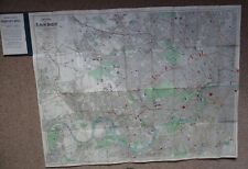
 1949 City Map of London UK England 14x11" sheet streets parks points of interest
-
$124.34
 Map "A Plan of Sr Christopher Wren's first design of St Paul's Cathedral" c.1730
-
$9.99
 1892 Map of Europe in 912 Franks Saxony Cordoba Spain Italy Hungary Germany UK
-
$15.00
 1900'S CLEAR PRINT MAP LONDON BY GEO PHILIP & SON
-
$11.99
 1937 Map London England Thames Westminister Parliament Picadilly Circus Strand
-
$9.99
 1896 Map France Spain Portugal Paris Madrid Lisbon Toledo Tours Lyon Barcelona
-
$225.00
 CHRISTOPHER WRENS PLAN FOR REBUILDING LONDON AFTER the CONFLAGRATION of 1666 MAP
-
$23.50
 London in time of Saxon Dynasty and Vikings c.1000 antique map art print poster


