 Antiques (US)
-
$157.73

 1925 Kansas City Missouri Atlas Plat Map RARE Color Lithograph Plate #116 & 117
-
$157.73
 1925 Kansas City Missouri Atlas Plat Map RARE Color Lithograph Plate #218 & 219
-
$157.73
 1925 Kansas City Missouri Atlas Plat Map RARE Color Lithograph Plate #186 & 187
-
$157.73
 1925 Kansas City Missouri Atlas Plat Map RARE Color Lithograph Plate #122 & 123
-
$36.00
 Large Original 1898 Antique Map CALIFORNIA Santa Clarita Ana Rosa Clara Monica
-
$24.99
 Originl 1925 Map South Dakota State Trunk Highway System COMMISSION SEPT 1 1925
-
$175.00
 1832 Hand-Colored Map of Mississippi, Louisiana and the Arkansas Territory, NOLA
-
$36.00
 Large Original 1898 Antique Map MONTANA Billings Bozeman Missoula Helena Havre
-
$18.00
 New jersey - Original 1891 Map by Hunt & Eaton. Antique
-
$15.99
 1949 New Mexico Official Highway Road Map Gas Station Nevada
-
$36.00
 Large Original 1898 Antique Map ARIZONA Phoenix Tucson Mesa Tempe Glendale Yuma
-
$13.95
 1892 Indian Territory Historic Vintage Style Oklahoma Wall Map - 18x24
-
$935.00
 Vereinigte Staaten von Nord America und Mexico 1831
-
$33.75
 1875 Iowa 17" Map Plan Decorah Charles City Northwood Elkader Strawberry Pt. S3
-
$29.73
 1898 Map of the State of CONNECTICUT Hand Colored Lithograph 10.75 x 7.25
-
$29.73
 1898 Map of the State of MAINE Hand Colored Lithograph 13.5 x 10.75
-
$36.00
 Large Original 1898 Antique Map INDIANA Evansville Hammond Carmel Lafayette Gary
-
$36.00
 Large Original 1898 Antique US Territory Map HAWAII Honolulu Maui Kauai Islands
-
$14.99
 USGS Planimetric Map St Louis Missouri Illinois 1985
-
$14.99
 USGS Planimetric Map Joplin Missouri Kansas 1986
-
$14.99
 USGS Planimetric Map Rolla Missouri 1986
-
$14.99
 USGS Topographic Map Mountain Grove Missouri 1983 quadrangle
-
$24.00
 Montreal Quebec - Original 1891 Street & Railroad Map Hunt & Eaton. Canada
-
$9.95
 1923 Hammond Map Utah on rev. Idaho showing Native American Reservations
-
$36.00
 Large Original 1898 Antique Map SOUTH CAROLINA Columbia Spartanburg Hilton Head
-
$18.00
 Arkansas, Louisiana & Mississippi - Original 1891 Map by Hunt & Eaton. Antique
-
$30.33
 1898 Map of the State of INDIANA Hand Colored Lithograph 13.5 x 10.75
-
$16.95
 Historic 1837 Map of Republic of Texas Land Grants by Stephen F Austin - 20x24
-
$33.75
 1875 Iowa 17" Map Mitchell County / Howard Co Cedar Falls & Minnesota Railway S3
-
$32.25
 1875 Iowa 17" Map Poweshiek Co Grinnell Montezuma Brooklyn Malcolm Plat CRI&P S2
-
$249.00
 Antique 1882 Florida & the Keys County Map Hand Colored Framed 23X19 By Bradley
-
$157.73
 1925 Kansas City Missouri Atlas Plat Map RARE Color Lithograph Plate #74 & 75
-
$13.95
 1851 New York City, New York Vintage Old Panoramic NY City Map - 18x24
-
$11.95
 Vintage Idaho Centennial 1890-1990 Official Highway Map - MINT
-
$13.99
 1951 New Mexico Official Highway Road Map Gas Station Nevada
-
$36.00
 Large Original 1898 Antique Map ARKANSAS Jonesboro Conway Rogers Benton Sherwood
-
$14.99
 USGS Topographic Map SPRING VALLEY Missouri 1986 100K
-
$21.30
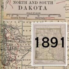 1891 DAKOTA MAP NORTH & SOUTH ANTIQUE FULL COLOR RAILROADS RIVERS MOUNTAINS
-
$157.73
 1925 Kansas City Missouri Atlas Plat Map RARE Color Lithograph Plate #222 & 223
-
$157.73
 1925 Kansas City Missouri Atlas Plat Map RARE Color Lithograph Plate #158 & 159
-
$7.00
 Vintage New Jersey Map
-
$300.00
 1838 Bradford map of Upper and lower Canada
-
$23.95
 1866 Schönberg's Early Map of Texas Historic Map 24x28
-
$22.50
 1912 Antique Arizona State Map Vintage Map of Arizona Gallery Wall Decor 1586
-
$15.18
 1872 Antique Map Southern U.S. States Map Approx 8”x10.25” Drawing Instructions
-
$23.95
 1835 Territory of Texas - Map of Land Grants - 24x30
-
$157.73
 1925 Kansas City Missouri Atlas Plat Map RARE Color Lithograph Plate #46 & 47
-
$9.09
 Vintage Amoco Vacation Planner Florida Map (D6)
-
$16.95
 Historic Map of New England 1747 Vintage Style Colonial Map - 20x24
-
$9.09
 Vintage 1948 Ray Walker's Resort Vacation Haverhill 1 Massachusetts Map (D4)
-
$9.09
 Vintage 1948 Ray Walker's Resort Vacation Haverhill 1 Massachusetts Map (D5)
-
$9.09
 Vintage Chevron Touring California Point of Interest Map (D7)
-
$12.95
 Marilyn Monroe Dies Newspaper Headlines 12 x 18 Poster
-
$13.95
 Bird's Eye View 1885 Hingham Massachusetts Vintage Style City Map - 16x24
-
$3.73
 National Geographic Map Of Western Canada - 1966 - Road Atlas
-
$25.00
 Vintage New York To Florida Upside Down Map Esso
-
$17.95
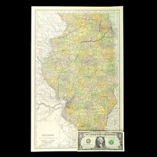
 1941 Vintage ILLINOIS Map Antique State Map of Illinois Atlas Map Decor 1583
-
$33.75
 1875 Iowa 17" Map Jasper Co Newton Prairie City Monroe Kellogg CRI&P Ry. Plat S2
-
$25.00
 The Spokane Valley WA - Rathdrum Prarie ID Aquifer Atlas / Map - 5th Edition NEW
-
$45.95
 Old 1909 Plat Map ~ AMBOY Twp., COTTONWOOD Co., MINNESOTA ~Free S&H
-
$18.95
 1923 Washington DC Vintage Old Panoramic City Map - 20x30
-
$20.95
 NYC New York 1879 Historic Panoramic Town Map - 20x36
-
$23.95
 1830s Texas & Indian Territory Land Grants Historic Wall Map - 24x30
-
$26.95
 Historic Map of New York City 1865 - 16x48
-
$25.95
 Colton's 1861 Map of the State of North Carolina - 24x36
-
$23.19
 Original 1819 Map Of South America
-
$28.05
 1945 Two-Sided Color Railroad Map of Virginia/Vermont Hammond 9.25x12.25"
-
$27.49
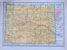 1945 Two-Sided Color Railroad Map of Wyoming/Wisconsin Hammond 9.25x12.25"
-
$18.95
 Bird's Eye View 1892 Dallas Texas Vintage Style City Map - 20x30
-
$13.95
 1875 Salt Lake City Utah Vintage Old Panoramic City Map - 18x24
-
$22.50
 1914 Antique ARIZONA State Map Vintage Map of Arizona Gallery Wall Art 1607
-
$13.95
 Bird's Eye View 1851 New Orleans Louisiana Vintage Style City Map - 18x24
-
$16.96
 Vintage ILLINOIS Map Railroad Wall Art Old Original Electric Rail Lines
-
$12.45
 Vintage 1937 Color Map of Alaska 11" x 14"
-
$13.95
 1623 Virginia and East Coast Colonial Wall Map - 16x24
-
$13.95
 1898 Chicago Illinois Vintage Old Panoramic City Map - 16x24
-
$20.00
 NORTH AMERICA. POLITICAL MAP OF UNITED STATES OF AMERICA. Antique map Circa 1880
-
$23.95
 1870s Map of State of Texas and Oklahoma Indian Territory - 24x28
-
$12.71
 Vintage KANSAS CITY Map Street Missouri Wall Art Original Antique DATED 1895
-
$74.95
 Original 1923 Boone County Illinois IL Atlas by Ogle & Co Plat Book
-
$33.75
 1875 Iowa Counties 28" Print Pocahontas Cherokee Ida Buena Vista Calhoun Sac S3
-
$13.56
 ca1920 Antique BROOKLYN Street Map of Brooklyn New York Gallery Wall Art Decor
-
$17.95
 Historical map of New York City 1932 Vintage Style Illustrated Map - 20x28
-
$40.00
 Wooden Topographic map of Arizona, 3D Map, Geographic Wall Art Relief Map
-
$18.95
 1890 Portland Oregon Vintage Old Panoramic City Map - 20x30
-
$13.95
 Bird's Eye View 1878 Holliston Massachusetts Vintage Style City Map - 18x24
-
$18.95
 1941 Vintage CLEVELAND City Street Map of Cleveland Ohio Gallery Wall Decor 1579
-
$6.22
 National Geographic Map Of Vacationlands Of The United States + Southern Canada
-
$14.95
 Prohibition End at last NY Newspaper Headlines 12 x 18 Poster
-
$13.95
 1868 Chicago Illinois Vintage Old Panoramic City Map - 16x24
-
$17.95
 1941 Antique New Jersey State Map Gallery Wall Decor Vintage Atlas Map 1582
-
$3.73
 National Geographic Map Of Eastern Canada - 1967 - Road Atlas
-
$46.00
 HTF Dibblee Geologic Map DF-19 TRANQUILLON & POINT ARGUELLO 1988 SB
-
$13.95
 Bird's Eye View 1889 Williamstown Massachusetts Vintage Style City Map - 16x24
-
$18.95
 1940s Vintage Boston Picture Map Liozu Boston Print Wall Art Decor 1560
-
$13.95
 Bird's Eye View 1878 Chicopee Massachusetts Vintage Style City Map - 18x24
-
$14.99
 Public Service Central Telephone Company Hickory NC USA Map Area Codes
-
$14.00
 USGS Topographic Map Otis Massachusetts 1987 1:25000 folded map
-
$180.00
 Framed Antique 1610 Bertius Peter Map Lake Como Italy
-
$150.00
 1941 Vermont Forest Service Ski Runs & Ski Tails Mount Mansfield Map


