 Antiques (US)
-
$24.65

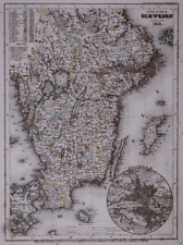
 1902 Mediterranean Sea Antique Map by G.W. Bacon over 120 Years Old
-
$30.82
 1860 Indian Ocean Beautifully Hand Coloured Antique Map by Blackie
-
$24.65
 1891 NORTH ATLANTIC OCEAN COLOUR MAP BY W.G. BLACKIE
-
$30.82
 1854 Ancient World Hand Coloured Antique Map by William Hughes
-
$19.99
 1901 Antique Map / THE WORLD
-
$24.99
 1880 Antique Atlas Map / WESTERN HEMISPHERE
-
$750.00
 Vintage Rare Rand McNally School Pull Down Roll Map 17 In 1
-
$16.99
 1880 Antique Atlas Map / EASTERN and WESTERN HEMISPHERES
-
$24.99
 1880 Antique Atlas Map / EASTERN HEMISPHERE
-
$19.90
 Vintage Soviet Poster USSR Political Advertising Communist Party Propaganda
-
$49.50
 1864 Map Prussia and the German States Antique Original Hand Colored Mitchell
-
$20.00
 Dated 1830 Universal Atlas Map of the WORLD ~(10x12)-#1246
-
$20.00
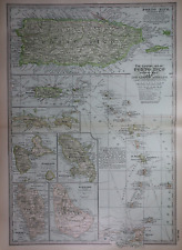 Old 1902 Century Atlas Map ~ PORTO RICO & THE LESSER ANTILLES ~(12x16) -#1138
-
$29.43
 1938 ORIGINAL VINTAGE POLITICAL MAP OF THE WORLD COLONIES BRITISH EMPIRE AFRICA
-
$43.15
 1814 Eastern Hemisphere by J. Russell Original Antique Map Over 200 Years Old
-
$24.65
 1902 Ancient World Original Antique Map by G.W. Bacon over 120 Years Old
-
$34.50
 Antique Map of Prussia 1865 Black's Atlas Edinburgh Color
-
$39.88
 1897 Map of the World ORIGINAL North America Africa Europe Africa Polar Views
-
$10.99
 Indexed Political Colored Map of the World 29" X 37"
-
$26.10
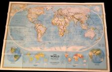 National Geographic Society THE WORLD MAP Physical Political 1994 43 x 30 inches
-
$12.00
 VTG World map 1960's printed on blue burlap 38" x 45"
-
$20.00
 Dated 1838 Universal Atlas Map ~ SCHWEDEN / SWEDEN - STOCKHOLM ~(10x12)-#1262
-
$120.00
 1861 Levasseur Planisphere World Map Seasons Zodiac Europe Africa Asia America
-
$38.75
 WORLD MAP 1844 (1849) Robinson, Olney School Geography WORLD MAP 11x18" G-VG
-
$20.00
 Dated 1831 Universal Atlas Map ~ GRIECHENLAND / GREECE - CANDIA ~ (10x12)-#1271
-
$49.50
 Germanic Confederation in Two Antique Maps 1865 Black's Atlas Edinburgh Germany
-
$20.00
 Old 1902 Century Atlas Map ~ JAPAN - KOREA ~(12x16) -#1175
-
$25.00
 Vintage Hammond International Map Of The World 50” X 33" Ship & Air Routes 1957
-
$65.00
 EASTERN & WESTERN HEMISPHERE MAPS by LESKE VOLLSTÄNDIGER SCHULATLAS 1832 (WORLD)
-
$43.16
 1782 Islands of the North Atlantic & North Pacific Oceans Antique Map
-
$87.99
 1880s Large Antique World Map on Mercators Projection
-
$26.08
 Original/Antique 1902 Map/India/South Asia/Bartholomew/Print
-
$54.00
 1896 World Map ORIGINAL Eastern Hemisphere Polar Views Africa North America
-
$48.88
 1898 Ancient World Maps Herodotus Descendants of Noah Libya Asia Africa ORIGINAL
-
$20.00
 Old 1902 Century Atlas Map ~ VICINITY of LONDON, ENGLAND ~ (12x16) -#1146
-
$20.68
 Dated 1839 Mitchell's Atlas Map ~ EUROPE - PRUSSIA, SARDINIA, BAVARIA, GALICIA
-
$20.00
 1865 McNally Atlas Illustration ~ CLIMATE ZONES of the WORLD ~(9x12) -#1130
-
$21.51
 Lg (16"x21") Old 1898 Atlas Map ~ AFRICA - SUEZ CANAL & LOWER EGYPT ~ Free S&H
-
$162.50
 1937 SUPERIOR SERIES CRAMS POLITICAL PULL DOWN MAP OF SOUTH AMERICA (17A)
-
$26.08
 AFRICA Original Antique 1902 Map Print Bartholomew
-
$20.00
 1878 Map ~ CHINA - SOUTHEAST ASIA ~ Original Atlas Map (14x20) Free S&H -#1516
-
$22.99
 Large-Format 1932 Boundary Disputes WORLD MAP Railroads Manchuria Bolivia Peru
-
$20.68
 Old 1898 Atlas Map of the WORLD ~ Free S&H
-
$20.68
 Dated 1839 Mitchell's Atlas Map ~ ASIA - HINDOOSTAN, RUSSIAN & CHINESE EMPIRES
-
$20.00
 Old 1902 Century Atlas Map ~ NORTHERN FRANCE ~ (12x16) -#1149
-
$20.00
 1865 McNally Atlas Map ~ AFRICA, UNEXPLORED REGION ~ (9x12) -#1126
-
$144.00
 Vintage Rand McNally School Pull Down Elementary Political Roll Map Canada
-
$20.00
 Old 1902 Century Atlas Map ~ NORTHEAST AFRICA ~(12x16) -#1177
-
$20.00
 Old 1902 Century Atlas Map ~ AFRICA ~(12x16) -#1176
-
$115.59
 VTG Modern Education System 6 Continents Political Pull Down Map 50” X 60” #25
-
$20.00
 1878 Map ~ GREECE - MOREA ~ Original Atlas Map (14x20) Free S&H -#1507
-
$800.00
 Antique Vintage Denoyer Geppert Political Pull Down Map of Africa Circa 1920's
-
$20.68
 Dated 1839 Mitchell's Atlas Map ~ SOUTH AMERICA - BUENOS AYRES, PATAGONIA
-
$7.20
 Vintage ATLANTIC OCEAN Atlas Map Print 1964 Encyclopedia Britannica World Atlas
-
$20.00
 Old 1902 Century Atlas Map ~ CENTRAL & SOUTHERN ITALY ~ (12x16) -#1162
-
$5.99
 1942 Highway Touring Map and A Map of The World by Jamestown Mutual Insurance
-
$179.99
 RAND McNally Simplified World 64 3/4" 3 Pull Down Map with bracket
-
$20.00
 Dated 1830 Universal Atlas Map ~ DENMARK - COPENHAGEN - SCHLESWIG ~(10x12)-#1261
-
$20.00
 Dated 1831 Universal Atlas Map ~ EUROPA / EUROPE ~(10x12)-#1248
-
$20.00
 Dated 1837 Universal Atlas Map ~ LOMBARDISCH / ITALY VENICE ~ (10x12)-#1277
-
$20.00
 1878 Map ~ SVCOTLAND ~ Original Atlas Map (14x20) Free S&H -#1502
-
$20.00
 Dated 1831 Universal Atlas Map ~ SOUTH AFRICA - CAPE COLONY ~ (10x12)-#1310
-
$44.50
 1865 Map Western United States Black's Atlas Edinburgh Bartholomew Antique Color
-
$20.00
 Old 1902 Century Atlas Map ~ ITALY ~ (12x16) -#1160
-
$19.99
 1951 Political Wall MAP OF THE WORLD Printed in Color Decorative Border Railways
-
$20.00
 Dated 1832 Universal Atlas Map ~ PELOPONNESUS / GREECE ~ (10x12)-#1287
-
$34.50
 1865 Map Persia Afghanistan Black's Atlas Edinburgh Bartholomew Persian Gulf
-
$20.00
 Dated 1832 Universal Atlas Map ~ CENTRAL AMERICA - WEST INDIES ~ (10x12)-#1307
-
$34.50
 1865 Map Greece or Hellas Black's Atlas Edinburgh Bartholomew Ionian Islands
-
$20.00
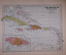
 Old 1902 Century Atlas Map ~ WEST INDIES / CARIBBEAN ~ (12x16) -#1191
-
$20.00
 Old Original 1896 Atlas Map ~ CARIBBEAN - JAMAICA ~ (11x14) -#1354
-
$20.68
 Old Antique 1890 Mitchell's Atlas Map ~ GREAT BRITAIN - IRELAND ~ Free S&H
-
$27.99
 1902 Oxford History World Map European Colonies Dependencies 1763 United States
-
$20.00
 1865 McNally Atlas Map ~ EASTERN HEMISPHERE of the WORLD (9x12) #1115
-
$20.00
 1889 Map ~ SPAIN - PORTUGAL ~ Authentic McNally Atlas Map (14x20) Free S&H -#011
-
$20.00
 Old Original 1896 Atlas Map ~ CENTRAL AMERICA - SAN SALVADOR ~ (11x14) -#1352
-
$20.00
 Dated 1838 Universal Atlas Map ~ UNGARN / HUNGARY ~ (10x12)-#1273
-
$20.00
 Old 1902 Century Atlas Map ~ DENMARK - ICELAND ~ (12x16) -#1156
-
$20.00
 Old 1902 Century Atlas Map ~ ONTARIO, CANADA ~ (12x16) -#1186
-
$20.00
 Old 1902 Century Atlas Map ~ VICINITY of PARIS, FRANCE ~ (12x16) -#1151
-
$20.00
 Old Original 1896 Atlas Map ~ CENTRAL AFRICA - CONGO FREE STATE ~ (11x14) -#1341
-
$20.00
 Old 1902 Century Atlas Map ~ TURKEY, RUMANIA, SERVIA, MONTENEGRO ~(12x16) -#1165
-
$20.00
 Old 1902 Century Atlas Map ~ THE NETHERLANDS BELGIUM LUXEMBERG ~ (12x16) -#1152
-
$20.00
 1875 Map ~ NORTH AMERICA ~ GREENLAND ~ Original Mitchell Atlas (11x15) -#1582
-
$20.00
 1878 Map ~ CARIBBEAN ~ Original Atlas Map (10x14) Free S&H -#1527
-
$20.00
 Old 1902 Century Atlas Map ~ NEW ZEALAND - PACIFIC OCEAN ISLANDS (12x16) -#1184
-
$19.90
 Vintage Soviet Poster USSR Political Advertising Communist Party Propaganda
-
$34.50
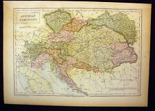 Austrian Dominions Antique Map 1865 Black's Atlas Edinburgh Austria Color
-
$20.00
 Old 1902 Century Atlas Map ~ THE GERMAN EMPIRE ~ (12x16) -#1153
-
$20.68
 1898 Atlas Map ~ THE NORTH POLE REGIONS - UNEXPLORED REGIONS - ARCTIC ~ Free S&H
-
$18.99
 Huge Colorful 1958 Wall Map THE WORLD ON MERCATOR PROJECTION by Rand McNally
-
$20.00
 Old 1902 Century Atlas Map ~ CENTRAL AFRICA ~(12x16) -#1179
-
$98.00
 South America Antique Vintage Rand McNally Pull Down Wall Map - 82661
-
$20.00
 Old 1902 Century Atlas Map ~ SOUTH PACIFIC / OCEANICA ~(12x16) -#1181
-
$20.00
 Old 1902 Century Atlas Map ~ CENTRAL MEXICO ~ (12x16) -#1189
-
$20.00
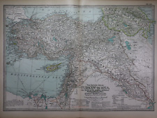 Old 1902 Century Atlas Map ~ TURKEY in ASIA ~(12x16) -#1168
-
$89.00
 Circa 1910 Map of Japan Empire George Philip & Sons, Ltd. London Geographical UK
-
$20.00
 Dated 1831 Universal Atlas Map ~ ASIEN / ASIA ARABIA SIAM CHINA ~(10x12)-#1249
-
$19.90
 Vintage Soviet Poster USSR Political Advertising Communist Party Propaganda
-
$39.99
 BUTLER'S One Book Course GEOGRAPHY Michigan Edition 1890 Relief & Political Maps


