 Antiques (US)
-
$39.88

 1874 Panama Caledonia Harbor Lithograph ORIGINAL Isthmus Darien Indian Village
-
$59.88
 1852 Isthmus Darien Map Canal Ship Navigation Plan New Granada Panama ORIGINJAL
-
$60.97
 VINTAGE ADMIRALTY CHART. No. 2267. GULF of PANAMA. 1915 Edition.
-
$185.39
 1906 COLON HARBOUR ISTHMUS OF PANAMA OLD VINTAGE ADMIRALTY CHART MAP
-
$1500.00
 Antique 18 Century Dutch Map Print of Cuba and the Caribbean (1)
-
$87.10
 Antique Map "Isthmus of Panama" John Tallis, 1851
-
$19.95
 East Point, Virgin Islands 1958 Photorevised 1982 Original USGS Topo Map
-
$35.95
 Mango Tango Map Virgin Islands 16 X 20 Antiqued Appearance Quality Paper Rolled
-
$5.25
 West Indies Caribbean Sea Map - Replica- Full Color - 22"x17"
-
$24.90
 1866 Hand-Colored Map of "West Indies" Approx 11" x 9" #20835
-
$33.99
 Antique US Hydrographic Maps - Barbados & Antigua - 40 x 33
-
$24.99
 Vintage MAP MEXICO, CENTRAL AMERICA AND THE WEST INDIES - 1894 A. L. Smith
-
$19.95
 Frederiksted, Virgin Islands 1958 Photorevised 1982 Original USGS Topo Map
-
$10.16
 1901 Spanish American War Lithograph Map of Cuba - I COMBINE SHIPPING
-
$40.00
 1879 Map Mexico West Indies Central America Victorian Geography 1st Ed DWAA9
-
$60.97
 VINTAGE ADMIRALTY CHART. No. 657. PANAMA CANAL. 1922 Edition.
-
$273.74
 Antique Map "Piano della Città di S. Domingo" (Dominican Republic)G. Pazzi, 1763
-
$74.64
 1851 Antique Map; Isthmus of Panama by John Tallis / Rapkin
-
$60.97
 ANTIQUE ADMIRALTY CHART. No.1931. GOLFO de NICUYA, COSTA RICA. 1911 Edition.
-
$1495.00
 VINCENZO CORONELLI Archipelague du Mexique Cuba Mexico Florida MAP 1st Ed 1688
-
$111.98
 Antique Map "Carta dell'isola di S. Cristoforo" (St Kitts Island) Bellin, 1770
-
$255.07
 Nautical Chart "West Indies S.to Domingo to Dominica" British Admiralty, 1948
-
$24.90
 1866 Hand-Colored Map of "Mexico, Central America & CA" Approx 11" x 9" #20834
-
$24.90
 1866 Hand-Colored Map of "South America" Brazil Approx 11" x 9" #20836
-
$138.00
 1799 Rare Map Gulf of Mexico, Florida, West Indies, Pierre Bertholon
-
$118.20
 Antique Map "West Indies" John Thomson, c.1819
-
$74.66
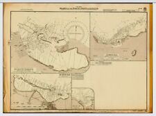
 Nautical Chart "Plans in Aruba, Bonaire and Curaçao Islands" U.K. Admiralty 1947
-
$4.99
 1949 state maps Puerto Rico & Virgin Islands 14x11" sheet counties cities towns
-
$150.00
 1956 West Indies South Coast of Cuba Gulf of Batabano Map
-
$31.11
 BERMUDA ISLANDS, WESTERN PART, 1925 ADMIRALTY SEA CHART. No.334
-
$31.11
 BERMUDA ISLANDS, GRASSY BAY, IRELAND ISLAND, 1888 ADMIRALTY SEA CHART. No.1074
-
$37.33
 St. VINCENT & THE GRENADINES, WEST INDIES, 1908 ADMIRALTY SEA CHART. No. 791
-
$50.00
 1925 pictoral map of Panama Canal
-
$7.99
 CENTRAL AMERICAN ATLANTIC COAST ACCORDING TO W. LAUER, 1960 Map
-
$62.20
 1851 Antique Map; Central America by John Tallis / Rapkin
-
$4.99
 1949 map Central America & Mexico 14x11" sheet rivers cities towns
-
$155.53
 Antique "Map of the Island of St. Christopher's" (Saint Kitts and Nevis) 1794
-
$30.00
 1929 UNITED STATES COAST GUARD WEST INDIES AND SOUTH PUERTO RICO MAP 44X36 EX
-
$85.85
 1882 PORT OF VERA CRUZ TAMPICO HARBOUR APRROACHES VINTAGE ADMIRALTY CHART MAP
-
$85.85
 1886 MEXICO MANGROVE BLUFF TO C. CORRIENTES VINTAGE ADMIRALTY CHART MAP
-
$68.43
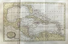
 WEST INDIES, CARIBBEAN, BERMUDA, BRITISH ISLANDS, Fullarton antique map c1860
-
$1500.00
 Antique French Map Print of Cuba and the Caribbean (2)
-
$19.00
 Vintage British Virgin Islands Dive Site Chart Map 24" x 18 1/4" Rare
-
$17.00
 1895 Antique Color MITCHELL Map of MEXICO & CENTRAL AMERICA ~ Large Original Map
-
$323.51
 Antique Map "Carta della Jamaica" Anonymous, c. 1770
-
$155.53
 ANTIQUE ADMIRALTY CHART. No.657, PANAMA CANAL and APPROACHES, 1915 Edition.
-
$73.41
 VINTAGE ADMIRALTY CHART. No. 697. DOMINICA. WEST INDIES. 1914. Edition.
-
$217.74
 Map "A Plan of the Siege of the Havana drawn by an Officer on the Spot, 1762"
-
$60.97
 VINTAGE ADMIRALTY CHART. No.867. The NARROWS, GRASSY BANK, BERMUDA. 1949 Edn.
-
$8.96
 Vintage USVI Maps Maritime Waterproof Nautical 35"x25" Virgin Islands 2 Large
-
$528.81
 Map "Carte Reduite de L'Isle de La Jamaique aux Vaisseaux du Roy" Bellin, 1753
-
$31.99
 NEW "Flukes Map of the Virgin Islands" Penciled Roger Ellis Signature 12X16
-
$186.64
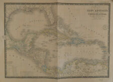
 Map "Carte des Iles-Antilles ou Indes Occidentales" (Caribbean) Brué, 1827
-
$29.99
 Rand McNally Central America Pocket Map 1915 Airways Railroads Mexico WW1 Panama
-
$7.45
 Nautical Charts Anguilla Sombrero Island BA 2047 + Admiralty letter
-
$43.54
 1807 Antique Map; The West Indies by James Barlow, Early Colour
-
$1450.00
 Yucatan Antique Map partie de la Nouvelle Espagne et Guatimala Montanus 1671
-
$18.66
 ADMIRALTY SEA CHART St Martin St Barthelemy West Indies Sea Chart No. 2079 1977
-
$223.97
 Antique map, Bellin, Carte du Golphe du Mexique et des isles de l'Amerique
-
$111.98
 Antique map, Abbe de la Porte, Isle de la Jamaique
-
$223.97
 Antique map, Bellin, Carte De L'Isle de la Jamaique
-
$22.40
 ADMIRALTY SEA CHART Approaches To Trinidad West Indies Sea Chart No. 493 1980
-
$111.98
 Nautical Chart "Guadeloupe to Trinidad" (Southern Caribbean) U.K. Admiralty 1947
-
$28.00
 Repro Vintage Map - Radio Society of Bermuda certificate. signed by Governor
-
$93.32
 Antique Map "Carta Esatta Rappresentante L'Isola di Granata" M. Coltellini, 1763
-
$74.66
 Antique Map "Grenada To Britain" George & Son Philip, 1851.
-
$124.43
 Chart "Jamaica and the Pedro Bank with parts of Cuba and Haiti" Coghlan, 1947
-
$87.10
 Antique map, Bellin, Carte du lac de Mexico et de ses environs
-
$99.54
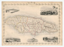 Antique Map "Jamaica" John Tallis, 1851
-
$248.85
 Antique Map "Carta Esatta Rappresentante l'Isola della Guadalupa" G. Pazzi, 1777
-
$18.66
 Double-sidedAntique Map. JAMAICA / CUBA. W & A K Johnston. 1895. VG.
-
$22.40
 ADMIRALTY SEA CHART Approaches To Barbados West Indies Sea Chart No. 2485 1980
-
$18.65
 Original Antique Map of West Indies (c1920) inc Central America - Stanford
-
$559.91
 Antique map, Bowen, An accurate map of the West Indies
-
$60.97
 VINTAGE ADMIRALTY CHART. No.587. BURICA POINT to MANGROVE BLUFF. 1914 Edn
-
$87.10
 Antique map, Bellin, Carte De L'Isle de la Guadeloupe
-
$18.66
 Double-sided Antique Map. MEXICO with the WEST INDIA ISLANDS. c1895. VG.
-
$549.99
 Original 1831 Friesz Nautical Map GUADELOUPE Marie-Galante Desirade Caribbean
-
$24.82
 c1890 George Philip West Indies Central America Antique Map Print Coloured Plate
-
$124.43
 Nautical Chart "West Indies - Jamaica" UK Admiralty, 1947
-
$22.40
 ADMIRALTY SEA CHART Dominica West Indies Sea Chart No. 697 1977
-
$55.99
 VINTAGE ADMIRALTY CHART. No.697. DOMINICA. 1914 Edition.
-
$31.11
 TRINIDAD, GULF OF PARIA, WEST INDIES, 1957 ADMIRALTY SEA CHART. No.493
-
$60.97
 VINTAGE ADMIRALTY CHART. No.457. PORTLAND BIGHT, JAMAICA. 1963 Edition.
-
$8.09
 ADMIRALTY SEA CHART. # 371. WEST INDIES. NORTHERN MARTINIQUE. 1991.
-
$43.55
 VINTAGE ADMIRALTY CHART. No. 451. Plans in NORTH WEST JAMAICA. 1933 Edition.
-
$72.31
 BRUÉ Map of Caribbean Carte des Isles Antilles des Etats Unis de L'Amérique 1860
-
$933.19
 Map "Mappa Geographica, complectens I. Indiae Occidentalis" Homann Heirs, 1740
-
$49.71
 c1840s West Indies Hand Coloured Antique Map Print Illustration Omnigraph Becker
-
$93.31
 1851 Antique Map; Jamaica by John Tallis / Rapkin
-
$62.20
 1839 Antique Map; West Indies: Caribbean, Florida, Venezuela after John Russell
-
$248.85
 Antique map, T. Mollo, Charte von West Indien nach den besten hulfsmitteln ..
-
$6.22
 National Geographic Vintage Sheet Map Paper Mexico & Central America 1953
-
$85.85
 c1854 ISTHMUS OF PANAMA Genuine Antique Map by Rapkin FREE POSTAGE WORLDWIDE
-
$167.97
 Antique map, Bodenehr, Der Neuen Welt Begriff .
-
$167.97
 Antique map, Tardieu, Carte des Antilles
-
$167.97
 Antique map, Guadaloupe
-
$12.44
 Vintage map MEXICO & WEST INDIES 1930s approx A3 size VGC
-
$110.74
 1829-32 WEST INDIA ISLANDS SAN SALVADOR TO SANTO DOMINGO ADMIRALTY CHART MAP
-
$85.85
 1878-9 MEXICO PORT ANGELES TO MANGROVE BLUFF VINTAGE ADMIRALTY CHART MAP


