 Antiques (US)
Africa Maps
Asia Maps
Australia/Oceania Maps
Celestial Maps
Central America/Caribbean Maps
Curiosities Maps
Digital Maps
Europe Maps
Map & Globe Mixed Lots
Map & Globe Reproductions
North America Maps
South America Maps
World & Celestial Globes
World Maps

-
$15.00

 Instagram Account ( Do Not Buy Here Text 313-686-4768) To Guy
-
$174.49
 MCM 1964 Vintage Masketeers 1628 World Map Brass and Wood Wall Metal Art 44 x 30
-
$180.00
 Framed Antique 1610 Bertius Peter Map Lake Como Italy
-
$100.00
 Parthian Empire Persia Iran Ancient World Assyria Scythia 1683 Mallet color map
-
$2500.00
 WORLD MAP 1685 JUSTUS DANCKERTS LARGE ANTIQUE ENGRAVED MAP 17TH CENTURY
-
$13.95
 1661 Celestial Map of the Constellations Historic Vintage Style Map - 16x20
-
$13.95
 Cuba 1639 Old Map Caribbean Ocean Maritime Chart - 14x24
-
$350.00
 Virginia Historical Society Framed Reproduction 1612 John Smith Map +Free Ship
-
$16.95
 1680s Early Map of North America - New Mexico - English Empire - 20x24
-
$23.95
 1689 Interesting Detailed Old World Exploration Map Poster - 24x28
-
$13.95
 1615 Map of Paris France Historic Old Map - 16x24
-
$13.95
 La Floride (Florida) 1657 Historic Old Map - 16x24
-
$13.95
 1630 Historic Old World Illlustrated Vintage Map - 16x24
-
$100.00
 Anatolia Asia Minor Cyprus Black Sea Turkey Rhodes Armenia 1683 Mallet hc map
-
$92.00
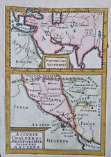 Ancient Assyria Mesopotamia Middle East Arabia Iran 1683 Mallet hand color map
-
$98.00
 Leros Kalymnos Dodecanese Islands Aegean Sea Greece 1683 Mallet decorative map
-
$180.00
 PEOPLE OF FLORIDA 1683 ALAIN MANESSON MALLET NICE ANTIQUE VIEW 17TH CENTURY
-
$24.95
 John Smiths Map of Virginia 1627 Vintage Style Illustrated Map - 24x32
-
$499.99
 Rare ANTIQUE 1676 HAND-COLORED MAP OF THE ROMAN EMPIRE JOHN SPEED 17th CENTURY
-
$13.95
1685 Map of the English Empire in America - 16x20
-
$29.99
 Accvrat Map Of The World 1626. Nicely Framed.
-
$13.95
 Persia and Arabia 1666 Historic Middle East Exploration Map - 16x20
-
$17.95
1620s “Virginia” Vintage Style Early Colonial America Map - 20x28
-
$13.95
1627 Map of Virginia by John Smith Historic Vintage Style Wall Map - 18x24
-
$118.12
 MALTA VALLETTA c1679 BY FRANCESCO SCOTO GENUINE ORIGINAL BIRDS EYE VIEW MAP
-
$62.00
 Antique Hand Coloured Map of Surrey by John Norden 1610 - 19" x 13 1/8" Frame
-
$23.95
1660s “Celestial Chart of the Zodiac” Vintage Style Astrology Map - 24x28
-
$21.99
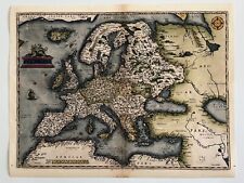 Old World Map of Europe 1600s Ancient Maps Vintage Style Poster Print
-
$179.99
 Vintage 1964 Masketeers Large Brass and Wood Map of the World in 1628 43” X 30”
-
$27.34
 16-17th CENTURY MAGNIFICENT MOUNTED PLAN MAP OF GOA INDIA
-
$120.00
 Arabian Peninsula Ancient World Persian Gulf Red Sea 1683 Mallet hand color map
-
$100.00
 Turkey Asia Minor 1683 Mallet miniature map w/ lovely hand color
-
$23.95
1685 Historic Map of Early North America - 24x28
-
$17.95
 Florida Caribbean Bahamas 1650’s Vintage Style Classic Map - 20x28
-
$35.00
 1695 ANTIQUE ROBERT MORDEN MAP 1st ISSUE " HEREFORD SHIRE " GENUINE HAND COLORED
-
$100.00
 Ancient Greece Attica Hellas Athens Corinth Euboea 1683 engraved map
-
$13.95
1650s “Insulae Americanae” Vintage Style US Caribbean Map - 18x24
-
$13.95
 1623 Virginia and East Coast Colonial Wall Map - 16x24
-
$24.85
 Old Map Of Warwickshire 1610 Replica
-
$120.00
 Arabian Peninsula Hejaz Mecca Medina Petra Red Sea 1683 Mallet hand color map
-
$795.00
 REGNI POLONIA N. VISSCHER 1690 HAND CLORORED MAP AFTER SANSON UKRAINE LITHUANIA
-
$13.95
 Jerusalem City Map 1660 Old Holy Land Town Plan - 16x24
-
$72.41
 Mallet Map TYPES OF SHIP 17th century original engraved print c1683
-
$16.95
Celestial Chart of the Zodiac 1661 Vintage Style Decorative Map - 20x24
-
$13.95
 1690s Vintage Style Illuminated Early Old World Map Poster - 16x20
-
$25.95
 1600's Astrology Interesting Old World Map - 24x36
-
$17.95
 1630s “Map of the Virginia Colonies” Vintage Style Chesapeake Bay Map - 20x28
-
$24.95
1630 Virginia Colonial Jamestown Historic Vintage Style Wall Map - 24x32
-
$1598.98
 Rare Antique Map Cartography Jan Joannes Janssonius Atlas Globe Geography 1660
-
$23.95
 Britannia Romana 1695 Vintage Style Roman England Provincial Map - 24x28
-
$45.00
 Vintage 1929 New York City Pictorial Map in 1658 Color Lithograph New Amsterdam
-
$24.95
 North America West Indies 1639 Vintage Style Early Exploration Map - 24x32
-
$100.00
 WALES CAERNARVONSHIRE 23.5” BLAEU 1640 ANTIQUE ORIGINAL COPPER ENGRAVED MAP.
-
$24.95
 1600s Nova Terrarum Orbis Old World Wall Map Art Print - 24x32
-
$30.00
 Sport Sumo Wrestling Japan - Original Engraving Montanus - 1670
-
$180.00
 ALBANIE GRANDE ARMENIE 1683 ALAIN MANESSON MALLET ANTIQUE MAP 17TH CENTURY
-
$29.99
 Franklin Mint Gunter's Quadrant solid brass Great Instruments of Discovery Serie
-
$40.00
 c 1693 MERIAN Antique Print Plan Labyrinth Versailles Chateau Gardens France Map
-
$105.68
 Antique Map of England by Petrus Bertius 1618
-
$250.00
 RARE ANTIQUE MAP -SOUTH AMERICA-HAND COLORED-VELLUM, C 1618
-
$24.95
 1660 de Wit Vintage World Celestial Historic Elemental Map - 24x32
-
$100.00
 Greece Kinaras Kalymnos Leros Dodecanese Islands Greek Islands 1683 Mallet map
-
$230.00
 NEWFOUNDLAND 1683 ALAIN MANESSON MALLET ANTIQUE MAP 17TH CENTURY FRENCH EDITION
-
$279.75
 BRITISH ISLES Britain, Frederick De Wit original antique map circa 1675
-
$79.00
 Battle Of Sluis Sluys Spanish Armada Sea Navy Netherlands Copperplate 1615
-
$130.00
 PRESBOURG BRATISLAVA SLOVAKIA 1683 ALAIN MANESSON MALLET NICE ANTIQUE VIEW
-
$16.95
1695 Old World Historic Vintage Style Wall Map Poster - 20x24
-
$24.95
 Paris 1620 Historic City Plan Vintage Map - 24x32
-
$25.95
 1650s Vinckeboons' Map of California as an Island - 24x36
-
$13.95
Hondius’ Early Map of Virginia 1630 Vintage Style Exploration Map - 18x24
-
$78.40
 Assyrian Empire Chaldea Mesopotamia Ancient Middle East 1683 Mallet map
-
$24.95
 1600s “Typus Orbis Terrarum” Vintage Style Abraham Ortelius Map - 24x32
-
$180.00
 Syria Levant Tripoli Antioch Beirut Sidon Tyre 1697 Cluverius decorative map
-
$380.00
 HISPANIOLA PUERTO RICO 1683 ALAIN MANESSON MALLET ANTIQUE MAP FRENCH EDITION
-
$24.95
 London 1680's Interesting Historic Old City Map - 24x32
-
$87.03
 British Isles map Mercator Hondius Jansson edition Original Anglia 1634
-
$190.00
 ERIVAN ARMENIA 1683 ALAIN MANESSON MALLET NICE ANTIQUE VIEW FRENCH EDITION
-
$78.40
 Ancient Asia Scythia Sarmatia Black Sea Caspian Sea Aral Sea 1683 Mallet map
-
$80.82
 SIENA TUSCANY ITALY c1679 BY FRANCESCO SCOTO GENUINE ORIGINAL BIRDS EYE VIEW MAP
-
$270.00
 CANADA NOUVELLE FRANCE 1683 A. MANESSON MALLET NICE ANTIQUE MAP FRENCH EDITION
-
$180.00
 HURONS CANADA 1683 ALAIN MANESSON MALLET NICE ANTIQUE VIEW 17TH CENTURY
-
$180.00
 PEOPLE OF VIRGINIA 1683 ALAIN MANESSON MALLET NICE ANTIQUE VIEW 17TH CENTURY
-
$13.95
 Cuba 1650 Map of the Caribbean Ocean Bahamas - 16x24
-
$795.00
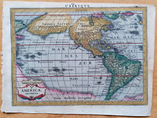 America Americae Descriptio - Original Map Mercator - 1651
-
$64.00
 c 1650 MERIAN Antique Map Print Fontainebleau Chateau & Gardens France
-
$79.20
 1696 J. Colom Map Vier Ambachten Hulst Flanders Zeeland Netherlands Axel Holland
-
$280.00
 CONSTANTINOPLE c. 1695 NICOLAS DE FER NICE ANTIQUE VIEW 17TH CENTURY
-
$93.25
 1627 Antique Map: Munster, Ireland - Miniature Speed / van den Keere
-
$120.00
 ARMENIANS 1683 ALAIN MANESSON MALLET NICE ANTIQUE ENGRAVED VIEW 17TH CENTURY
-
$13.95
 1636 North American Historic Vintage Style Explorers Wall Map - 16x20
-
$220.00
 LUCAYES ISLANDS BAHAMAS 1683 ALAIN MANESSON MALLET ANTIQUE MAP FRENCH EDITION
-
$38.03
 3 Antique Reproduction Maps BY Rand McNally 1695, 1626, 1589
-
$39.99
 Vintage Africae nova descriptio 1672 By WILLEM JANSZOON BLAEU (Print Poster)
-
$16.95
 1660 Phases of the Moon - Plate 19 of the Harmonia Macrocosmica - 20x24
-
$79.20
 1696 Jacob Colom Map Gelders Duchy Arnhem Zwolle Maastricht Heusden Netherlands
-
$2900.00
 1681 The World in Planisphere authentic Map, A New System of Mathmatics, Moore
-
$55.95
 Shropshire by Robert Morden 1695 antique map Camden's Brittania hand coloured
-
$186.50
 Antique 1611 John Speed Framed Map Devonshire Excestor Exeter Devon
-
$224.50
 Antique Map-GERMANY-RHINE-HEIDELBERG-Sanson-1674
-
$499.95
 Artby ChristianVan Adrichom Jerusalem Map Iversalem Unframed Color 1682 Replica


