 Antiques (US)
Africa Maps
Asia Maps
Australia/Oceania Maps
Celestial Maps
Central America/Caribbean Maps
Curiosities Maps
Digital Maps
Europe Maps
Map & Globe Mixed Lots
Map & Globe Reproductions
North America Maps
South America Maps
World & Celestial Globes
World Maps

-
$31.70

 1912 ANTIQUE CELESTIAL MAP OF NORTHERN SKY HEAVENS STARS ASTRONOMY
-
$26.03
 1912 ANTIQUE MAP OF TURKEY BLACK SEA CRIMEA PALESTINE ISRAEL LEVANT VERSO SMYRNA
-
$26.03
 1912 ANTIQUE POLITICAL MAP OF ASIA CHINA INDIA SAUDI ARABIA / VERSO TURKEY
-
$38.66
 1914 ANTIQUE MAP OF CITY OF KOLBERG KOŁOBRZEG POMERANIA POMMERN / POLAND GERMANY
-
$250.00
 Antique 1914 12” W. & A.K. Johnston Terrestrial Globe with Clawfoot Base.
-
$19.99
 1919 TAMPA HARBOR FLORIDA HILLSBORO BAY SHOWING WATER TERMINALS & TRANSFERS MAP!
-
$10.99
 Wonderful WWI Era Antique / Vintage Long Island Atlas Map NY New York City L@@K!
-
$18.00
 Oklahoma - Original 1911 Dated Map by Dodd Mead & Company. Antique
-
$399.99
 RARE Original BMT 1944 New York City NYC 21" x 24" Subway Map Brooklyn Bronx +++
-
$15.00
 Vintage Longmans Map of Southeastern Europe and Asia Minor in 1892
-
$19.99
 1915 Bamberg,South Carolina Signed W.H. Miley Hand Drawn (NAMES) COLORFUL MAP
-
$29.99
 1919 ST. JOHNS RIVER FLORIDA JACKSONVILLE TO TROUT CREEK SHOWING OWNERSHIP MAP!
-
$29.98
 The New Encyclopedic Atlas and Gazetteer of the World 1919 Edition
-
$23.44
 1911 ANTIQUE MAP OF WESTERN AFRICA SAHARA NIGERIA MOROCCO SENEGAL CANARY AZORES
-
$200.88
 Antique 1916 ST GABRIELS PARK MANHATTAN NEW YORK CITY Map ST VARTAN PARK BROMLEY
-
$23.76
 1914 ORIGINAL ANTIQUE MAP OF THAILAND SIAM BURMA MYANMAR MALAYSIA SINGAPORE
-
$9.99
 1914 DEPT OF THE INTERIOR OFFICE OF INDIAN AFFAIRS BLACKFEET PROJECT MONTANA MAP
-
$45.00
 Lot 10 Different Vintage USGS Washington State Topographic Maps 1910-50's 8
-
$12.95
 1914 Vintage IDAHO Railroad Map Wall Art Decor Old Original Boise Antique
-
$8.02
 1902 Map of Italy antique vintage Britannica 10th
-
$9.99
 1916 U.S. WEATHER BUREAU COLOR MAP LOWEST TEMPERATURES EVER OBSERVED!
-
$45.95
 Vintage 1910 Map ~ MARSHALL COUNTY, ILLINOIS ~ Old & Original ~ Free S&H
-
$19.00
 German Empire - Original 1910 Dated Map by Dodd Mead & Company. Antique
-
$21.90
 1910s KONIGSBERG VINTAGE MAP Prussia Kaliningrad City Russia ORIGINAL C10-1
-
$68.00
 Montgomery County Maryland Large Original Vintage 1916 Wall Map 33 by 39 Inches
-
$19.99
 1914 THE DELTA OF COLORADO RIVER SALTON SEA & IMPERIAL VALLEY COLOR MAP!
-
$14.50
 1912 Plat Map Part of White Earth Indian Reservation Clearwater County Minnesota
-
$32.18
 1914 ANTIQUE MAP OF HELIGOLAND / HELGOLAND / CUXHAVEN / GERMANY
-
$26.68
 1911 ANTIQUE PHYSICAL MAP OF AFRICA / SAHARA KILIMANJARO MOUNTAINS RIVERS
-
$30.46
 1911 ANTIQUE MAP OF ANATOLIA TURKEY OTTOMAN EMPIRE ARMENIA PALESTINE ISRAEL IRAQ
-
$23.76
 1912 ANTIQUE MAP OF CENTRAL AFRICA BRITISCH GERMAN COLONIES CONGO VERSO RHODESIA
-
$149.95
 Original Antique Denny’s pocket map of Sutter County, California 1913
-
$25.00
 Original 1918 Blueprint of Temple, PA by Hintz and Fisher in Tube
-
$9.99
 1917 McNally Map Louisiana New Orleans Baton Rouge Lake Charles Pontchartrain LA
-
$15.00
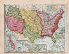 1911 ANTIQUE RAND MCNALLY NEW IDEAL ATLAS MAP-UNITED STATES EXPANSION
-
$19.95
 CENTURY ATLAS MAP PLATE #48 "OKLAHOMA" CITY TULSA CHEROKEE ORIG ANTIQUE 1911 OK
-
$28.88
 1915 East WIlliamsburg Brooklyn Map Broadway Triangle Flushing Harrison
-
$35.96
 Vintage 1911 CHICAGO ILLINOIS Map 15"x23" ~ Old Antique Original HUMBOLDT PARK
-
$24.65
 1902 Africa Original Antique Map by G.W. Bacon over 120 Years Old
-
$23.76
 1912 ANTIQUE MAP OF SOUTH AFRICA TRANSVAAL FREE ORANGE STATE NATAL / PRETORIA
-
$9.99
 1914 UNITED STATES INDIAN SERVICE FLATHEAD PROJECT MONTANA MAP 8.75 x 9!
-
$34.99
 Vintage Color Folio Geologic Atlases of the United States, 1894 - 1945 PICK ONE!
-
$28.76
 Vintage 1912 OKLAHOMA Map 22"x14" ~ Old Antique Original GUTHRIE STILLWATER OK
-
$9.99
 1915 BUFFALO HARBOR NY INNER HARBOR ENTRANCE CHANNEL MAP 19.25 x 27!
-
$25.00
 Antique 1914 HAMMONDS Handy Atlas of the World with new census Hard Back
-
$25.00
 SAN FRANCISCO 1912 September dated ORIGINAL plan map USA California
-
$27.50
 1912 Antique California State Map Vintage Atlas Map California Wall Decor 1589
-
$28.50
 1910 Plat Map Frankfort Township Will County Illinois Mokena Original
-
$49.88
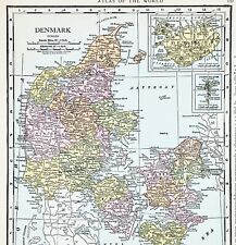 1916 Denmark Map Iceland Zeeland Copenhagen Maribo Faroe Islands Skanderborg
-
$164.88
 1916 INWOOD MANHATTAN NEW YORK CITY NY Land Street Map INWOOD HILL PARK ON BACK!
-
$24.00
 Cleveland, Ohio - Original 1910 City Map by Dodd Mead & Company. Antique
-
$13.95
 1917 Vintage CLEVELAND Map City Street Old Original Cleveland Ohio Antique Road
-
$28.50
 1910 Plat Map Town of Frankfort Will County Illinois Stillwagon Bowen Otter
-
$14.50
 1912 Plat Map Itasca Township Clearwater County Minnesota Mallard Gill Lake
-
$20.00
 Large Pristine 1912 McNally Relief Map of PORTO RICO ~ (XL14x20) #1295
-
$9.99
 1916 MUSKINGUM RIVER BASIN OHIO ENGINEERING MAP!
-
$27.50
 1912 Antique COLORADO State Map Vintage Map of Colorado Gallery Wall Decor 1588
-
$24.00
 Southeast Asia - Original 1913 Dated Map by Dodd Mead, Indochina Vietnam Siam
-
$17.95
 1916 Antique Map of The World Original Color Ocean Currents & Routes Railroads
-
$22.50
 1912 Antique Arizona State Map Vintage Map of Arizona Gallery Wall Decor 1586
-
$35.24
 Vintage 1911 CHICAGO ILLINOIS Map 15"x23" ~ Old Antique Original GARFIELD PARK
-
$48.00
 1915 Murray Hill New York Map Kips Bay Rose Hill St Vartan Park Manhattan LARGE
-
$31.64
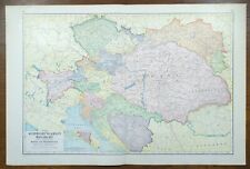 Vintage 1911 AUSTRIA HUNGARY BOSNIA Map 23"x15" ~ Old Antique Original VIENNA
-
$38.88
 1915 New York Map ORIGINAL Harlem Upper Manhattan St Nicholas Park Fifth Avenue
-
$27.50
 1912 Antique Philippines Map Vintage Map of the Philippine Islands Map 1600
-
$38.88
 OLD 1915 MICHIGAN Map ORIGINAL COUNTIES Allegan Ottawa Kent St Joseph Van Buren
-
$20.00
 Alabama - Original 1911 Map by The Century Company. Antique
-
$20.00
 Old Authentic 1912 McNally Atlas Map ~ EUROPE ~ (XXL20x28) #1315
-
$9.75
 1910 Antique Color Map of The World 17" x 27"
-
$14.50
 1912 Map State of Minnesota Original Color 15" x 23"
-
$28.50
 1910 Plat Map New Lenox Township Will County Illinois Marley Spencer Original
-
$18.00
 Texas & Oklahoma - Original 1911 Map by Dodd Mead & Company. Antique
-
$8.02
 1902 Map of Japan and Korea antique vintage Britannica 10th
-
$19.50
 Beautiful Antique 1914 - 2 Piece Map Of Paris France 15x11 Inches
-
$8.02
 1902 Map of East India Islands Indonesia Borneo antique vintage Britannica 10th
-
$18.50
 1916 Plat Map Newton Township Calhoun County Michigan Lee's lake Cotton Lake
-
$59.95
 Antique 1912 Book: 'The Library Atlas of the World' Vol. II Foreign Countries
-
$12.95
 Vintage MISSISSIPPI Map State Wall Art Decor Jackson Hattiesburg Antique
-
$19.99
 1911 Stieler Map Turkey Constantinople Iraq Palestine Syria Cyprus Jerusalem
-
$8.02
 1902 Map of Scotland antique vintage Britannica 10th
-
$17.50
 1910 Plat Map City of Joliet Illinois Des Plaines River Railroad & McDonough #16
-
$48.88
 1915 Bedford Stuyvesant Brooklyn Map Fulton Broadway Rockaway Lewis
-
$48.88
 ANTIQUE 1915 Willisburg BROOKLYN Map Greenpoint McCarren Park New York GOWANUS
-
$9.99
 Wisconsin, Grant County 1918 Plat Map Towns/ Clifton Lima Potosi village
-
$8.02
 1902 Map of Netherlands Belgium and Luxemburg antique vintage Britannica 10th
-
$17.55
 1919 Antique Germany Map Prussia Bavaria Poland Map Wall Decor 1225
-
$19.50
 Antique 1914 Map Of Atlanta 11x15 Inches
-
$28.00
 1916 NORWAY SWEDEN Map ORIGINAL Stockholm Christiania Gothenburg Halmstad Bergen
-
$9.99
 Wisconsin, Grant County 1918 Plat Map Towns of Paris & Harrison
-
$45.88
 1916 Kansas Map Dubuque Wichita Hutchinson Pottawatomie Dodge City Railroads
-
$9.99
 1914 OFFICE OF INDIAN AFFAIRS FORT PECK PROJECT MONTANA MAP 9 x 12!
-
$14.50
 1912 Map State of The United States Original Color 15" x 23"
-
$35.00
 An antique Original 1917 Poole Bros. map for the Alaska Steamship Co
-
$17.95
 1916 Plat Map City of Princeton North Half Bureau County Illinois Original Color
-
$18.00
 Nebraska - Original 1910 Dated Map by Dodd Mead & Company. Antique
-
$48.88
 1916 UNITED STATES Map ORIGINAL LARGE Wisconsin Indiana Pennsylvania Delaware
-
$17.99
 Earliest AAA Road Map New England 1911
-
$28.88
 1915 BROOKLYN NEW YORK Map South Williamsburg Bedford Stuyvesant Naval Cemetery
-
$23.76
 1912 ANTIQUE MAP OF BENGAL CENTRAL PROVINCES VERSO CALCUTTA / BRITISH INDIA
-
$26.03
 1910 ORIGINAL ANTIQUE MAP OF ASIA CHINA JAPAN KOREA INDIA SAUDI ARABIA RUSSIA


