 Antiques (US)
-
$135.92

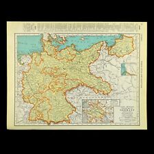
 1934 ATLAS BOOK Full of MAPS German Vintage B8
-
$249.99
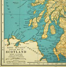
 Original Story Map of Scotland Colortext Publication 1935 Framed Map S9610
-
$39.95
 Map of Europe Poster Reproduction Super High Quality Print 24"x18"
-
$60.00
 Bykovka Russia Soviet Union Belgorod Oblast c. 1943 WWII rare German topo map
-
$12.95
 Vintage EUROPE Map Wall Art Decor Old Original 1940s WWII Era Antique
-
$11.95
 1947 Vintage POLAND Map Post WWII Map of Czechoslovakia Wall Art Decor
-
$11.86
 Vintage GERMANY Map Wall Art Old Original Prussia Berlin ca 1937 PreWar
-
$31.86
 1937 ORIGINAL VINTAGE MAP OF ROMANIA MOLDOVA / TRANSYLVANIA
-
$22.00
 Pomerania & Posen, Germany - Original 1937 Map by Velhagen & Klasing. Vintage
-
$12.71
 Vintage POLAND Map Wall Art Old Original 1920s Pre WWII Map Warsaw Krakow
-
$12.95
 ca1937 Vintage SCOTLAND Map Wall Art Old Original Edinburgh United Kingdom
-
$49.99
 5 Antique 1920’s/1940's LONDON ENGLAND MAPS/GUIDE BOOKS/ATLAS Paper/Cloth Travel
-
$11.86
 Vintage TURKEY Map Armenia Iraq Syria 1930s Baghdad Palestine Cyprus Istanbul
-
$60.00
 Krasny Russia Smolensk Oblast c. 1943 WWII rare German very detailed topo map
-
$90.00
 1931 MAP OF ROMAN BRITAIN - LINEN BACKED FOLD-OUT - ORDNANCE SURVEY - J 9504
-
$44.00
 East Prussia Baltic States Latvia Livonia Lithuania 1936 large Italian map
-
$9.99
 Vintage WWII Era Paris France Subway System Transportation Map
-
$29.95
 Vtg Antique WWII Map Of Rome Italy Compliments Of The American Red Cross (A10)
-
$22.50
 Italy Sardinia Adriatic Mediterranean Sea 1935 Map Europe 14 x 11" LGAD99
-
$12.80
 WWII Map Pursuit West Wall France Belgium Germany Bradley Patton Aug-Sept 1944
-
$12.80
 WWII Map Allied Occupation Zones US British French Russia Berlin Germany 1945
-
$13.56
 ca 1937 Vintage ATLANTIC OCEAN Map Antique Shipping Routes Map Wall Art Decor
-
$11.99
 West Point WWII Map Invasion Sicily Allied Beachheads Advance Italy July 15 1943
-
$11.20
 1937 McNally Map Scotland Edinburgh Aberdeen Glasgow Dundee Loch Ness Inverness
-
$11.99
 West Point WWII Map Invasion Sicily Allied Advance Patton Italy July 23, 1943
-
$23.76
 1939 VINTAGE MAP OF EASTERN MEDITERRANEAN SEA GREECE TURKEY ARMENIA / CYPRUS
-
$15.26
 ca1943 Occupied FRANCE Map Wartime WWII Vichy Regime Vintage Paris Antique
-
$12.00
 WWII Map Battle of Normandy Breakout Falaise Pocket Mortain France Aug 1-13 1944
-
$120.00
 Western Mediterranean WWII era U.S. Navy Coastal Survey 1942 huge navigation map
-
$84.11
 1938 Nat Geo Bible Lands and the Cradle of Western Civilization Map (35”x25”)
-
$60.00
 Kudever' Russia Pskov Oblast c. 1943 WWII rare German detailed topo map
-
$100.00
 SCARCE - WWII POLISH MAP - TAJNE - Bydgoszcz County, POLAND -
-
$16.00
 Original 1933 Map of The Ruhr, Germany by Meyers. Ruhrgebiet. Vintage
-
$230.02
 1934 Cecily Peele Map of Oxford and Her Worthies - Hand Painted In Colour 1948
-
$21.37
 1938 ORIGINAL VINTAGE OF MAP FRANKISH EMPIRE FRANKS MEDIEVAL GERMANIC TRIBES
-
$16.96
 1930s Vintage POLAND Map Wall Art Pre WWII Map World War II Warsaw Krakow
-
$15.99
 West Point WWII Map Invasion of Sicily Allied Advance to Messina Italy Aug 1943
-
$60.00
 Ernest Dudley Chase, Map of France, 1935, Full margins. Pictorial Map.
-
$224.99
 RARE ORIGINAL 1930's Walter Riemer Propoganda/tourist Map of Pre-WWII Germany
-
$60.00
 Schimsk Russia Soviet Union Lake Ilmen Novgorod c. 1943 WWII topographical map
-
$24.99
 Antique 1930 Map Of New England In Excellent Condition
-
$14.40
 Soviet Finnish War Map Battle of Suomussalmi Russia Finland Dec Jan 1939-40
-
$19.50
 MAP OF EUROPE - 1934 COLOR Antique Print
-
$10.99
 Vintage French Map 1939 World War 2
-
$21.37
 1937 VINTAGE HISTORICAL MAP CENTRAL EUROPE POLAND GERMANY AUSTRIA SWEDEN IN 1791
-
$18.00
 WWII Map Eastern Europe Front Germany Prussia Poland Latvia Russia Summer 1944
-
$6.59
 Vintage Map Europe 1st Quarter 16th Century ~ Book Plate European Civilization
-
$12.80
 WWII Map 6th 12th Army Battle Aachen Belgium Germany Patton Rhine Sept-Dec 1944
-
$12.00
 1939 map of Russia Soviet Union 2 sided Asia for framing Colliers World Atlas
-
$11.99
 West Point WWII Map Rome Campaign Anzio Landing Cassino Battle Italy Mar 1944
-
$18.00
 1930 ORIGINAL VINTAGE MAP LOWER SAXONY EMDEN LEER OLDENBURG GERMANY NETHERLANDS
-
$49.99
 Antique WWII German Map Reichskarte Krefeld Essen
-
$8.63
 23666 Shell Tour Card Map 104 Berlin Saarow Scharmützelsee Um 1935
-
$11.99
 West Point WWII Map Salerno Campaign Italy Allied Landing Amalfi Sept 9, 1943
-
$11.99
 1937 McNally Map France Paris Marseilles Toulouse Bordeaux Nantes Lyon Tours FR
-
$14.00
 1937 McNally Map Ireland Dublin Cork Wexford Galway Kerry Belfast Limerick Clare
-
$15.19
 WWII Map Poland Campaign Battle Warsaw Modlin Jaworow Lwow Germany Sept 28 1939
-
$16.96
 1940 Occupied FRANCE Map WWII Wartime Vichy Regime Antique Vintage Paris
-
$12.80
 WWII Map Rhineland Campaign Coblenz Mainz Luxembourg France Germany Feb Mar 1945
-
$11.99
 1937 McNally Map Scandinavia Norway Sweden Denmark Finland Stockholm Oslo Baltic
-
$6.22
 Brtholomew's Street Index Plan of London - North-East Section c1930
-
$11.20
 1937 McNally Map British Isles Great Britain & Ireland England Scotland London
-
$19.51
 1940 Occupied FRANCE Map WWII Wartime Vichy Regime Antique Vintage Paris
-
$5.93
 Vintage Map Japanese Conquest of China - 1939 Book Plate European Civilization
-
$13.86
 1939 Country Map of Iran Afghanistan Baluchistan and India Highly Detailed
-
$15.19
 WWII Railroad Map Poland Campaign 1939 Warsaw Danzig Germany Silesia Industry
-
$5.42
 Vintage Map Europe - 1939 Book Plate European Civilization C.S. Hammond & Co.
-
$8.99
 1938 Map Of Europe 33 1/2" x 39" Folded
-
$27.01
 20115 Map Esso Luftbildkarte for Drivers 23 Stettin Mark Pommern 1936
-
$22.63
 1933 VINTAGE CITY MAP OF WORMS / RHINELAND-PALATINATE / GERMANY
-
$12.38
 1932 Nile River Delta Africa Interpretive Map Print Van Loon Geography Art
-
$24.99
 1920s-1930s Relief-Panorama of the Rhine, Color Foldout Map, Hoursch 64" long
-
$12.80
 WWII Map Battle of Flanders Belgium Invasion Netherlands Holland Germany 1940
-
$13.86
 1939 Country Map of Germany & Hungary and Spain & Portugal Highly Detailed
-
$9.99
 West Point WWII Map Winter Line Rapido River Advance Cassino Italy Jan 1944
-
$30.00
 2 Ordnance Survey Wall Maps Britain -Dark Ages North sheet South sheet 1938
-
$18.00
 WWII Map Western Europe Allied Invasion Omaha Beach Normandy France June 6, 1944
-
$16.00
 WWII Map Eastern Europe Berlin Germany Austria Final Russian Campaign May 1945
-
$12.80
 WWII Map Encircling the Ruhr Pocket Essen Germany Patton Eisenhower April 1945
-
$11.86
 Vintage BRITISH ISLES Map United Kingdom Wall Art Decor ca 1937 Original London
-
$16.16
 1938 Antique PARIS France Street Map Wall Decor City Map of Paris France 706
-
$625.10
 1931 Map of Maryland & Surrounding Areas Depicts Historical & Cultural Events
-
$20.19
 1938 ORIGINAL VINTAGE MAP OF BALKANS YUGOSLAVIA SERBIA GREECE VERSO ITALY ISTRIA
-
$13.86
 1939 Country Map of Europe and the British Isles Highly Detailed
-
$22.44
 1934 MAP 6 x 9" (15 x 23 cm) - ATHENS & Environs Piraeus Eleusis Greece
-
$15.38
 Northern England 1938 Original Antique Map
-
$18.94
 1940 ORIGINAL VINTAGE WWII PHYSICAL MAP OF ALPS / SWITZERLAND ITALY
-
$11.99
 West Point WWII Map Salerno Campaign Italy German Counter Attack - Sept 14, 1943
-
$12.42
 CENTRAL LIVERPOOL CITY PLAN - 1930 Antique Map by Bartholomew
-
$330.61
 Wall Map Geological V.Germany 207x161 ~ 1935 Vintage German Geological Map
-
$22.57
 1930 ORIGINAL VINTAGE CITY MAP OF CHUR / COIRE / GRAUBUENDEN / SWITZERLAND
-
$18.00
 1937 VINTAGE PHYSICAL MAP OF EUROPE GERMANY POLAND FRANCE ITALY GREAT BRITAIN
-
$12.71
 1930s Vintage Map of AUSTRIA Antique Pre WWII AUSTRIA Map Gallery Wall Art Decor
-
$18.00
 1933 ORIGINAL VINTAGE CITY MAP OF NIJMEGEN / GELDERLAND / NETHERLANDS HOLLAND
-
$24.00
 Western Czechoslovakia - Original 1937 Map by Velhagen & Klasing. Vintage
-
$14.99
 Carey Lea 1831 Map Vindelicia Austria Yougoslavia Hamm
-
$16.00
 WWII Map Eastern Europe Ukraine Poland Lithuania Latvia Russian Offensive 1944
-
$22.57
 1930 ORIGINAL VINTAGE MAP OF VICINITY OF SYRACUSE / SIRACUSA / SICILY / ITALY
-
$60.00
 Wernigerode Saxony-Anhalt Germany c. 1931 Weimar era tourist pocket folding map
-
$24.08
 1937 National Geographic Map of The British Isles (36”x29.5”) Good Condition


