
-
$9.59

 1960's Vintage ROMAN EMPIRE Atlas Map - Old Antique Rand McNally World Atlas
-
$9.88
 1960's Vintage AGE OF DISCOVERY Atlas Map - Old Antique Rand McNally World Atlas
-
$545.80
 1960 Jo Lowry Geographical Guide to Woman's, Man's Heart Pictorial Map Matrimony
-
$118.61
 Vintage Philips Educational Map 'The Journeys of St Paul' - 1967
-
$20.99
 MAP OF THE SOLAR SYSTEM 1960 NYC BOOK ENTERPRISES FOLD-OUT MAP LARGE MAP
-
$10.15
 1960's Vintage EUROPE IN 1721 Atlas Map - Old Antique Rand McNally World Atlas
-
$16.22
 National Geographic Map - Australia - 1963 - Vintage
-
$9.04
 1960's Vintage ALEXANDER'S EMPIRE Atlas Map - Antique Rand McNally World Atlas
-
$8.74
 1962 LARGE MAP ~ NEW ZEALAND NORTH ISLAND AUCKLAND AND ENVIRONS
-
$12.47
 1964 CANADA St LAWRENCE RIVER Entrance ADMIRALTY Map Chart 28" x 48" D64
-
$24.96
 1966 CANADA Nova Scotia STRAIT of CANSO Admiralty Map Chart 28" x 41" D100
-
$24.96
 National Geographic Map - Indian Ocean Floor - 1967 - Vintage
-
$32.46
 Antique Map of The British Graham Land Expedition & earlier Antarctic Expeds
-
$16.22
 Antique/Vintage Map of Western Dronning Maud Land - 1955
-
$24.96
 Antique/Vintage Map of Depth of the Polar Ice Caps - 1954
-
$22.46
 Antique/Vintage Map of The Arctic Flights of the Aries - 1946
-
$18.72
 National Geographic Map - West Indies - 1962 - Vintage
-
$31.20
 National Geographic Map - The Nile Valley - 1965 - Vintage
-
$24.96
 National Geographic Map - Eastern South America - 1955 - Vintage
-
$37.44
 1963 SPAIN & FRANCE South Coast NAUTICAL Sea Navigation Chart MAP 28" x 52" B72
-
$24.96
 1965 ARGENTINA River Plate CABO Dos BAHIAS Navigation Sea MAP 28" x 41" B33
-
$11.22
 1960s era NO 60 MICHELIN LE MANSPARIS 09 MAP 1CM TO 2KM SCALE
-
$56.18
 VINTAGE MAP-MAKING TODAY POSTER~RICS XMAS LECTURE/EXHIBITION~LONDON~CARTOGRAPHY
-
$11.22
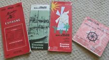 4.1960S ERA TOURIST LEAFLETS 3 WITH MAPS BALEARES ISLES,PALMA ,ESPAGNE MICHELIN
-
$4.37
 VINTAGE MAP KAART VAN TEXEL NETHERLANDS 1962
-
$24.96
 1969 North Coast SPAIN FOZ to CAMARINAS Admiralty Navigation Map 28" x 41" D68
-
$24.96
 MODERN COPY MAP SOMERSETSHIRE 1830 BY T.L.MURRAY 48CMS BY 39CMS
-
$39.99
 CENCO model 12041 NAMES, FORMULAS, AND IONIC CHARGES OF COMMON IONS Chart 1962
-
$24.96
 1969 FLAMBOROUGH HEAD to RIVER TYNE Admiralty Map Sea Chart 28" x 41" C58
-
$37.44
 x1969 NAHA KO Nansei Shoto Okinawa Shima JAPAN Sea Map Chart 28" x 41" D03
-
$31.20
 1969 NEW ZEALAND North Island - Port of TAURANGA Sea Chart MAP 28" x 41" B67
-
$89.99
 ANTIQUE GERMAN HUMAN BODY SKELETON CANVAS SCHOOL MAP MAPPA CARTE KARTE 1960s
-
$72.54
 VINTAGE LARGE MAP of BRITAIN AIRPORTS 1960 PASSENGER FREIGHT TRAFFIC LONDON
-
$25.99
 1960's 中国歷史掛圖 商朝疆域地圖 Chinese School Educational Map of ancient China Shang
-
$68.67
 Vintage SYMBOLS & ABBREVIATIONS Used on Admiralty Navigation Charts 20"w x 28"h
-
$62.43
 Road Atlas Great Britian 1965 Before Motorways Were Built
-
$31.20
 1962 West Africa CAP BLANC to RIVER GAMBIA Admiralty Sea MAP CHART 28" x 41" D09
-
$24.96
 1965 MEXICO BAHIA SAN HIPOLITO to ROSARIO Navigation Sea MAP CHART 28" x 41" C36
-
$18.72
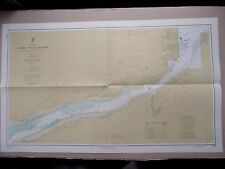 1969 CANADA Saint Lawrence River QUEBEC-ST ANTOINE Navigation Map 23½" x 41" B30
-
$18.72
 1969 TUNISIA to LIBYA Keliba~Tripoli - Admiralty Sea MAP CHART 28" x 41" D11
-
$37.44
 1969 TURKEY West MARMARA DENIZI Sea Navigation Chart MAP 28" x 41" B70
-
$24.96
 1969 Germany KIELER HAFEN-FJORD Baltic - Admiralty Sea MAP CHART 41" x 28" C81
-
$24.96
 1967 The SOUND Denmark & Sweden ENTRANCE to BALTIC SEA MAP Chart 28" x 47" D31
-
$14.97
 BIG PAPER MAP ATLANTIC WAR ERA 1968 GREAT GIFT POTENTIAL 60/44CM
-
$24.96
 1969 THE SOUND Copenhagen Denmark Sweden BALTIC SEA MAP Chart 28" x 47" D33
-
$37.44
 1969 AUSTRALIA Queensland PORT of MACKAY & BOWEN Sea Chart MAP 28" x 46½" B65
-
$37.44
 1965 BALTIC SEA Western Sheet - Nautical Sea Navigation Chart MAP 28" x 41" B75
-
$24.96
 MODERN COPY MAP OF PART OF MIDDLESEX 57CMS BY 42CMS
-
$515.85
 "LA LUNE" JACQUES DEVOS, Pictorial maps 1968, offerte par Le Journal de Spirou.
-
$24.96
 1966 ITALY - The GULF of GENOA Port & Harbour Plans MAP Sea Chart 28" x 41" C97
-
$24.96
 1965 Central America GULF of HONDURAS Nautical Sea Map Chart 28" x 20½" B16


