
-
$6.94

 New York State Canalway Trail Map-cycling/biking Trail
-
$6.89
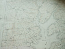
 Ordnance Survey Landranger Map Lincoln & Area Sheet 112 1:50,000 dated 1994
-
$12.55
 Vintage Marine chart - Admiralty Charts 192 East Schelde
-
$10.03
 Devon Ordnance Survey Map Large 1992 SX49 NW Halwill Witherdon Wood Upcott
-
$12.55
 Vintage Marine chart - Admiralty Charts 120 West Schelde
-
$19.95
 Hudson WI - MN Vintage 1993 USGS Topographical Geological Survey Quadrangle Map
-
$23.84
 ADMIRALTY CHART. No.2540. LOCH ALSH and APPROACHES. 1992 Edition.
-
$25.00
 Pawling Quadrangle New York Vintage Lithograph Topographic Map - unused
-
$12.53
 SEA ADMIRALTY SHIPPING SAILING SHIP YACHT CHART-NORTH SEA DOVER AND CALAIS
-
$8.16
 ADMIRALTY SEA CHART. # 371. WEST INDIES. NORTHERN MARTINIQUE. 1991.
-
$20.00
 Woodstock North Quadrangle Vermont Vintage Lithograph Topographic Map - unused
-
$25.09
 Vintage Admiralty Chart. No.1729. ISLANDS IN AMERICAN SAMOA. PACIFIC OCEAN.1990.
-
$7.52
 Nautical Charts Anguilla Sombrero Island BA 2047 + Admiralty letter
-
$10.03
 West Devon Ordnance Survey Map SW Roadford Lake Broadwoodwidger Large 1992 SX49
-
$10.03
 West Devon Ordnance Survey Map NE Beaworthy Northlew South West Large 1992 SX49
-
$11.99
 Independent Hill Quadrangle Virginia Manassas 1994 USGS Topographical Map
-
$31.37
 U. S. SEA CHART. No. 12304. DELAWARE BAY. NEW JERSEY - DELAWARE. 1991.
-
$12.55
 Vintage Marine chart - Admiralty Charts 203 Zante To Paxos
-
$12.55
 Vintage Marine chart - Admiralty Charts 1349 Ports In Normandy
-
$14.43
 ADMIRALTY SEA CHART. THAMES ESTUARY, KNOCK JOHN. No.1609. ENGLAND E. COAST. 1992
-
$9.41
 CHART MAP DEFENSE MAPPING DMAAC Soundings 52” X 35" TURKEY GREECE 54407
-
$1.57
 Michelin map sheet 80, Albi, Rodez, Nimes, France vintage 1999, 1:200000 yellow
-
$18.81
 let's see INVERNESS & LOCH NESS - By Dr Mould
-
$12.55
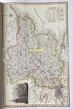
 Reproduction Historic map Thomas Moule of County Isle Of Wight, 1830
-
$31.35
 Garnons Williams Framed Map of the QE2 & Other Historic Atlantic Ocean Crossings
-
$12.55
 Vintage Marine chart - Admiralty Charts 97 Zeebrugge / Brugge
-
$12.55
 Reproduction Historic map Thomas Moule of County Hampshire, 1830
-
$20.08
 PUNTA STILO to BRINDISI, ITALY SOUTH EAST COAST, 1990 ADMIRALTY SEA CHART No.187
-
$12.55
 Vintage Marine chart - Admiralty Chart 1975 Thames Estuary Northern Part
-
$12.55
 Reproduction Historic map Thomas Moule of County Norfolk, 1830
-
$12.55
 Reproduction Historic map Thomas Moule of County Cornwall, 1830
-
$6.21
 Lake District Touring Map Sheet 3 1:63,360
-
$65.00
 1999 JERSEY CITY REDEVELOPMENT MAP ZONING HISTORIC DISTRICTS NEW JERSEY HISTORY
-
$12.55
 Reproduction Historic map Thomas Moule of County Nottinghamshire, 1830
-
$31.35
 STANFORD 1998 ERA 1/25000 LARGE MAP CHART FOLDED LIGHT WEAR NORFOLK
-
$31.35
 STANFORD 1998 ERA 1/25000 LARGE MAP CHART FOLDED LIGHT WEAR NORFOLK -
-
$12.55
 Reproduction Historic map Thomas Moule of County London, 1830
-
$5.01
 London Nicholson Pocket Map 1993
-
$18.82
 Map London Bermondsey & Wapping 1872 (Pub. 1995) Sheet 77 Bridge Docks Thames
-
$12.55
 Reproduction Historic map Thomas Moule of County Oxford University, 1830
-
$3.75
 Yokohama Paradise Tourist Map
-
$31.35
 Unique Media Map: Niagara Falls Laminated
-
$12.55
 Reproduction Historic map Pivot & Co’s of County Cheshire, 1840
-
$12.55
 Reproduction Historic map Pivot & Co’s of County Sussex , 1840
-
$12.55
 Reproduction Historic map Pivot & Co’s of County Hertfordshire, 1840
-
$12.55
 Reproduction Historic map Thomas Moule of County Cheshire, 1830
-
$12.55
 Reproduction Historic map Thomas Moule of County Suffolk, 1830
-
$2.50
 Purbeck in Dorset 1993 Official Map and Guide - colour
-
$12.55
 Reproduction Historic map Thomas Moule of County Lincolnshire, 1830
-
$12.55
 Reproduction Historic map Thomas Moule of County London, 1830
-
$12.55
 Reproduction Historic map Thomas Moule of County Cambridgeshire, 1830
-
$12.55
 Reproduction Historic map Thomas Moule of County Leicestershire, 1830
-
$12.55
 Reproduction Historic map Thomas Moule of County Bedfordshire, 1830
-
$12.55
 Reproduction Historic map Thomas Moule of County Dorsetshire, 1830
-
$12.55
 Reproduction Historic map Pivot & Co’s of County Suffolk , 1840
-
$12.55
 Reproduction Historic map Pivot & Co’s of County Worcestershire , 1840
-
$12.55
 Reproduction Historic map Pivot & Co’s of County Wiltshire , 1840
-
$12.55
 Reproduction Historic map Pivot & Co’s of County Cambridgeshire, 1840
-
$12.55
 Reproduction Historic map Thomas Moule of County West Yorkshire, 1830
-
$12.55
 Reproduction Historic map Pivot & Co’s of County Lancashire, 1840
-
$12.55
 Reproduction Historic map Pivot & Co’s of County Bedfordshire , 1840
-
$12.55
 Reproduction Historic map Thomas Moule of County Somersetshire, 1830
-
$12.55
 Reproduction Historic map Thomas Moule of County East Yorkshire, 1830
-
$12.55
 Reproduction Historic map Thomas Moule of County Portsmouth, 1830
-
$12.55
 Reproduction Historic map Thomas Moule of County Herefordshire, 1830
-
$12.55
 Reproduction Historic map Thomas Moule of County Hertfordshire, 1830
-
$12.55
 Reproduction Historic map Thomas Moule of County Gloucestershire, 1830
-
$12.55
 Reproduction Historic map Thomas Moule of County Shropshire, 1830
-
$12.55
 Reproduction Historic map Thomas Moule of County Monmouthshire, 1830
-
$12.55
 Reproduction Historic map Thomas Moule of County Cambridge, 1830
-
$12.55
 Reproduction Historic map John Tallis York 1855
-
$18.81
 Admiralty Chart - 2860 Outer Approaches to New York 1968 (1985 Printing)
-
$12.55
 Reproduction Historic map Thomas Moule of County Lancashire, 1830
-
$12.55
 Reproduction Historic map Thomas Moule of County Northamptonshire, 1830
-
$12.55
 Reproduction Historic map Pivot & Co’s of County Oxfordshire, 1840
-
$12.55
 Reproduction Historic map Thomas Moule of County Buckinghamshire, 1830
-
$12.55
 Reproduction Historic map Thomas Moule of England Wales, 1830
-
$12.55
 Reproduction Historic map Pivot & Co’s of County Herefordshire, 1840
-
$12.55
 Reproduction Historic map Thomas Moule of County Rutlandshire, 1830
-
$12.55
 Reproduction Historic map Thomas Moule of County Devonshire, 1830
-
$12.55
 Reproduction Historic map Pivot & Co’s of County Warwickshire , 1840
-
$12.55
 Reproduction Historic map Pivot & Co’s of County Huntingdonshire, 1840
-
$12.55
 Reproduction Historic map Pivot & Co’s of County Middlesex, 1840
-
$12.55
 Reproduction Historic map Pivot & Co’s of County Essex, 1840
-
$12.55
 Reproduction Historic map Pivot & Co’s of County Surrey, 1840
-
$12.55
 Reproduction Historic map Pivot & Co’s of County Buckinghamshire, 1840
-
$12.55
 Reproduction Historic map Pivot & Co’s of County Berkshire , 1840
-
$12.55
 Reproduction Historic map Thomas Moule of County Oxfordshire, 1830
-
$12.55
 Reproduction Historic map Thomas Moule of County Berkshire, 1830
-
$12.55
 Reproduction Historic map Thomas Moule of County Essex, 1830
-
$12.55
 Reproduction Historic map G. Coke and J. Riper Chester Cheshire
-
$12.55
 Reproduction Historic map Thomas Moule of County Worcestershire, 1830
-
$12.55
 Reproduction Historic map Pivot & Co’s of County Kent, 1840
-
$12.55
 Reproduction Historic map Pivot & Co’s of County Leicestershire & Rutland, 1840
-
$12.55
 Reproduction Historic map Thomas Moule of County Plymouth & Devonport, 1830
-
$12.55
 Reproduction Historic map Thomas Moule of County Derbyshire, 1830
-
$12.55
 Reproduction Historic map Thomas Moule of County Durham, 1830
-
$12.55
 Reproduction Historic map Pivot & Co’s of County Cornwall, 1840
-
$12.55
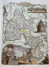
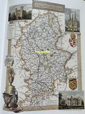 Reproduction Historic map Thomas Moule of County Staffordshire, 1830
-
$12.55
 Reproduction Historic map G. Coke and J. Riper Cumberland, Carlisle 1801


