-

$22.58
 Original antique map NORTH WALES, ANGLESEY, CARDIGAN BAY, John Cary, 1819
-
$6.15
 NEWQUAY & PADSTOW Ordnance Survey Paper One inch 1961 Sheet 185 Newquay Bodmin
-
$140.00
 MAN & ANGLESEY ISLANDS 1683 ALAIN MANESSON MALLET ANTIQUE MAP 17TH CENTURY
-
$120.00
 CHANNEL ISLANDS 1851 JOHN TALLIS 19TH CENTURY DECORATIVE ANTIQUE ENGRAVED MAP
-
$82.81
 ANGLESEY. Menai Strait Holyhead Bangor Beaumaris Caernarvon. WARD LOCK 1906 map
-
$38.90
 North west Wales coast antique map by J & C Walker. Anglesey. Railways 1870
-
$50.18
 1947 Ordnance Survey Folding Maps 6 mile= inch. Aethwy, Anglesey. Sewerage
-
$6.27
 CAERNARVON - ANGLESEY Ordnance Survey 2½ Inch Sheet SH 46 Map - Two and a Half
-
$23.84
 N WALES. Carnarvon Merioneth Denbigh Anglesey Flint; Liverpool;Cardiff 1920 map
-
$190.00
 Anglesey, anno 1791, copperengraving, Reilly F.J.
-
$11.28
 1894 Vintage antique County Map of Carnarvon & Anglesey by FS Weller in colour
-
$31.37
 NW WALES. Llandudno Caernarvon Snowdonia Anglesey Bangor. WARD LOCK 1951 map
-
$5.65
 1960 Bartholomew’s Half Inch Map Great Britain Sheet 27 North Wales cloth map
-
$15.04
 North Snowdonia. Menai Strait Anglesey Caernarfon Gwynedd. Sketch map 1885
-
$9.41
 An A3 size reproduction map of Anglesey original dated 1880.
-
$31.37
 NW WALES. Llandudno Caernarvon Snowdonia Anglesey Bangor. WARD LOCK 1950 map
-
$30.11
 OLD MAP OF ANGLESEY 1611 BY JOHN SPEED 24" x 16" PHOTOGRAPHIC PRINT
-
$31.37
 NW WALES. Llandudno Caernarvon Snowdonia Anglesey Bangor. WARD LOCK 1930 map
-
$1700.00
 Anglesey Antiently called Mona, Described 1610.: SPEED, John. ORIGINAL-OLD COL.
-
$17.57
 BANGOR. Town/city plan & environs. Menai Bridge. Menai Strait. Anglesey 1902 map
-
$10.03
 VINTAGE ORDNANCE SURVEY 1" MAP of Anglesey (1965) Wales, Welsh, Mon - Sheet 106
-
$31.37
 NW WALES. Llandudno Caernarvon Snowdonia Anglesey Bangor. WARD LOCK 1961 map
-
$35.13
OLD MAP OF ANGLESEY 1611 BY JOHN SPEED 30" x 20" PHOTOGRAPHIC PRINT
-
$300.00
 IRELAND 1851 JOHN TALLIS 19TH CENTURY DECORATIVE ANTIQUE ENGRAVED MAP
-
$138.02
 ANGLESEY, the Menai Strait, North Carnarvonshire & Conwy Estuary. CARY 1832 map
-
$18.82
 ANGLESEA - Antique Map - Drawn / Engraved by J. Archer , c1845
-
$57.72
 WALES (North West). Anglesey Snowdonia Gwynedd. Antique map by GW BACON 1884
-
$138.02
 ANGLESEY, the Menai Strait, North Carnarvonshire & Conwy Estuary. CARY 1832 map
-
$55.21
 WALES (North West) Anglesey Snowdonia Gwynedd antique map by GW BACON 1885
-
$60.23
 WALES (North West) Anglesey Snowdonia Gwynedd antique map by GW BACON 1891
-
$138.02
 Anglesey and Carnarvan by van den Keere. "Speed miniature" 1632 old map
-
$345.00
 Channel Islands Old Map Anglesey Wight Mercator 1638
-
$62.74
 ANGLESEY SNOWDONIA NORTH Conwy Snowdon Bangor Llandudno Caernarvon 1939 map
-
$15.04
 Vintage Bartholomew Map of North Wales - 1960 - Sheet 27, Gwynedd, Anglesey
-
$12.53
 Vintage Bartholomew's Half Inch Map - North Wales - 1960 - Sheet 27
-
$150.56
 Holy-Head sea chart. Holy Island & HOLYHEAD, Anglesey. Capt. COLLINS 1693 map
-
$185.00
 England and Wales Antique map by Tallis/Rapkin 1851
-
$30.11
 Antique map of Anglesea Island by John Seller / Francis Grose. Anglesey c1780
-
$188.21
 MENAI STRAIT sea chart. Anglesey Bangor Conwy Caernarfon.COLLINS 1693 old map
-
$22.57
 Victorian Colour Map of Carnarvon (c1896) Ordnance Survey - N Wales, Anglesey
-
$244.67
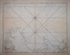 CARDIGAN BAY AND ANGLESEY BY CAPT GREENVILLE COLLINS, CIRCA 1750.
-
$376.41
 CARNARVON SHIRE AND ANGLESEY BY BLAEU CIRCA 1648


