 Antiques (US)
-
$15.39

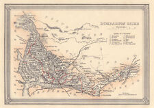
 1885 Dunbartonshire County Map, Scotland. Victorian map. 137 yrs old. Dumbarton.
-
$16.55
 1902 Parliamentary Map of Scotland map. 121 years old. Argyllshire, Lanarkshire.
-
$16.21
 1868 Victorian map of Stirling, Dunbarton and Renfrew. 154 years old.
-
$20.05
 1922 large map of Ayrshire, Renfrewshire & Dunbartonshire. 101 years old. Bute.
-
$24.89
 Admiralty Chart - No.2006 - GOUROCK to DUMBARTON, RIVER CLYDE - 1934 Edn.
-
$24.89
 Admiralty Chart - No.2007 - DUMBARTON to GLASGOW, RIVER CLYDE - 1934 Edn.
-
$17.00
 1907 Map Scotland:Railways, Canals, County Seats (inv21)
-
$23.81
 Scotland Map 1907 Authentic (Dated) County Burgh Port Canal Topogr'y Cable Rail
-
$29.88
 OLD MAP OF DUNBARTONSHIRE 1648 BY JOHAN BLAEU 24" x 16" PHOTOGRAPHIC PRINT
-
$14.93
 DUNBARTONSHIRE Coloured Antique Map 1885
-
$4.98
 County map of Dumbarton Scotland Dumbartonshire Loch Lomond Clyde c1895
-
$7.46
 Old Antique Map Dunbartonshire Scotland 1600's: Timothy PONT, BLAEU: REPRINT
-
$12.45
 Vintage Admiralty Chart 2007 Scotland - River Clyde 1979 Edition
-
$16.19
 Decorative antique county map of Dunbartonshire. FULLARTON 1868 old
-
$23.66
 ADMIRALTY SEA CHART. LOCHS LONG, GOIL & ETIVE. No.3739. .SCOTLAND W. COAST. 1957
-
$18.68
 Decorative antique county map of Dunbartonshire. FULLARTON 1866 old
-
$7.47
 Ordnance Survey Loch Lomond mounted on cloth 1961
-
$15.56
 DUMBARTON SHIRE Scotland John Bartholomew Original Antique Map c1883
-
$186.77
 CLYDE ESTUARY & LOCH LOMOND. Glasgow Dunbartonshire Stirlingshire. CARY 1832 map
-
$186.77
 CLYDE ESTUARY & LOCH LOMOND. Glasgow Dunbartonshire Stirlingshire. CARY 1832 map
-
$224.12
 Dunbartonshire & Dumbarton town plan. Glasgow Lomond Trossachs. THOMSON 1832 map


