 Antiques (US)
-
$63.00

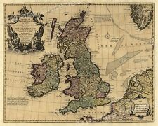
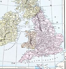 1898 British Isles Historical Map England Ireland Scotland Wales London
-
$48.88
 1912 Carolingian Empire Map EUROPE France Burgundy Germany Austria Medieval
-
$48.00
 1846 Europe Map Italy France Spain Madrid Palermo Milan Toulouse Greece
-
$38.00
 1843 Europe Map Prussia Germany Iceland Ireland POLITICAL Russia Moscow Austria
-
$48.88
 1898 British Islands ENGALND Map Anglo-Saxon and Celtic Kingdom Ireland Scotland
-
$48.88
 OLD 1896 Map PARIS LONDON BERLIN DUBLIN ROME ST PETERSBURG VIENNA EDINBURGH
-
$38.00
 1890 Saxon Medieval England Scotland Map London Hadrian's Wall Picts Shetland
-
$38.88
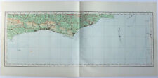
 OLD 1899 Southern England Wales Map London Cornwall STEAMSHIPS RAILWAYS PORTS
-
$38.88
 OLD 1853 ENGLAND IRELAND Map ORIGINAL Wales Scotland London Dublin Glasgow
-
$38.88
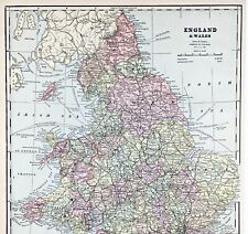
 1897 England and Wales Map Cornwall Dorsey Cardiff Portsmouth Hastings Bristol
-
$58.88
 1899 Northern England Wales Map Liverpool Sheffield STEAMSHIPS RAILWAYS PORTS
-
$9.95
 Ordnance Survey Map Wales and the Marches 1959 Quarter Inch Map
-
$58.88
 1953 Europe Map Italy Germany Prussia England Russia Crimea Spain Paris London
-
$54.88
 1899 Central Europe Map ORIGINAL France Belgium Germany STEAMSHIPS RAILWAYS
-
$58.00
 1956 Europe Map Topographical Elevations France Turkey Asia Yugoslavia Germany
-
$58.88
 1899 London ENGLAND Map ORIGINAL River Thames Ipswich RAILROADS Battlefields
-
$48.88
 1898 FRANCE Map HISTORICAL English Plantagenets Dukedom EUROPE ORIGINAL
-
$48.88
 1897 England Map London Ramsgate Oxford Buckingham Reading Hampstead Richmond
-
$199.00
 1927 Booklovers Map of the British Isles pictorial mounted framed P Paine Bowker
-
$48.88
 1852 Spain France Italy Portugal Map EUROPE Rome Madrid Paris Lisbon Normandy
-
$38.88
 1855 Great Britain Map ORIGINAL England Ireland Scotland Wales London Dublin
-
$48.00
 ENGLAND WALES Map 1889 ORIGINAL London Dover Railways Counties Townships G. CRAM
-
$37.29
 CHESHIRE LANCASHIRE LANCASTER KENDAL CARLISLE ROAD MAP BY JOHN SENEX c1757
-
$48.00
 1899 Europe Map ORIGINAL France Germany Austria Spain England Italy Turkey
-
$48.00
 1853 Europe Map ORIGINAL Turkey Russia Prussia Iceland Sardinia England Sweden
-
$31.07
 YORKSHIRE YORK LINCOLN NOTTINGHAM NEWARK STAMFORD ROAD MAP BY JOHN SENEX c1757
-
$43.50
 LONDON ABINGDON GLOUCESTERSHIRE ROAD MAP BY JOHN SENEX c1762 ORIGINAL ANTIQUE
-
$37.29
 LONDON CHICHESTER SURREY HERTFORD ROAD MAP c1757 BY JOHN SENEX ORIGINAL ANTIQUE
-
$38.88
 OLD 1897 Europe Map Russia Switzerland Baltic States Ireland Denmark Hungary
-
$699.99
 Antique Original 1676 Merionethshire John Speed Wales Britain W COA Hand Colored
-
$57.50
 England & Wales United Kingdom London 1772 Jefferys decorative hand color map
-
$62.17
 1747 Roman Britain Original Antique Map by Richard Seale
-
$24.85
 LANCASHIRE LANCASTER CUMBRIA KENDAL BY EMANUEL BOWEN c1720 GENUINE ANTIQUE MAP
-
$15.87
 1977 Vintage VISITORS' LONDON w/ Underground Fold-Out Color Map England UK
-
$9.93
 HULL 1910 ANTIQUE CITY PLAN Colour Map - Mounted For Framing
-
$9.93
 GLOUCESTER 1910 ANTIQUE CITY PLAN Colour Map - Mounted For Framing
-
$9.93
 CARDIFF 1910 ANTIQUE CITY PLAN Colour Map - Mounted For Framing
-
$9.93
 DERBY & LEICESTER 1910 ANTIQUE CITY PLAN Colour Map - Mounted For Framing
-
$23.50
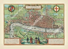 antique Elizabethan Tudor FIRST MAP OF LONDON Braun & Hogenberg 1572 art poster
-
$50.36
 Vintage 1887 LONDON ENGLAND Map 21"x13" ~ Old Antique Original KENSINGTON PARK
-
$18.00
 Europe - Original 1906 Political Map by Meyers. A German Language Antique
-
$9.93
 HULL 1910 ANTIQUE CITY PLAN Colour Map - Mounted For Framing
-
$28.30
 1894 ORIGINAL ANTIQUE MAP OF LONDON ZOO / LONDON ZOOLOGICAL GARDENS
-
$9.93
 STRATFORD ON AVON 1910 ANTIQUE CITY PLAN Colour Map - Mounted For Framing
-
$9.93
 WORCESTER 1910 ANTIQUE CITY PLAN Colour Map - Mounted For Framing
-
$9.93
 WINCHESTER 1910 ANTIQUE CITY PLAN Colour Map - Mounted For Framing
-
$9.93
 SALISBURY 1910 ANTIQUE CITY PLAN Colour Map - Mounted For Framing
-
$9.93
 PLYMOUTH 1910 ANTIQUE CITY PLAN Colour Map - Mounted For Framing
-
$9.93
 NORTHAMPTON & COVENTRY 1910 ANTIQUE CITY PLAN Colour Map - Mounted For Framing
-
$41.72
 Vintage 1901 LONDON ENGLAND UK Map 11"x14" ~ Old Antique Original REGENTS PARK
-
$39.56
 Vintage 1904 LONDON ENGLAND Map 11"x14" ~ Old Antique Original BATTERSEA CHELSEA
-
$18.00
 England & Wales - Original 1905 Geological Map by Meyers Geologische Karte
-
$35.99
 Vintage 1902 LONDON ENGLAND Map 11"x14" ~ Old Antique Original KENSINGTON PALACE
-
$9.95
 Vintage Map of ENGLAND Wall Art Railroad Decor Original 1950s Railway London
-
$22.00
 Herefordshire Worcestershire Warwickshire - Original 1922 Ordnance Survey Map.
-
$8.08
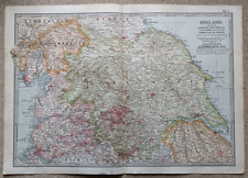 1902 Map of Yorkshire Westmorland Lancashire antique vintage Britannica 10th
-
$70.00
 Eighteenth Century Hand-Col. Map of London & Environs, 1787 - PRICE REDUCED
-
$19.99
 1869 Antique Mitchell COLOR Map / GREAT BRITAIN AND IRELAND
-
$50.36
 Vintage 1900 ENGLAND & WALES Map 14"x22" Old Antique Original BRITAIN UK LONDON
-
$35.00
 Vintage Maps - Ireland, Scotland, England and Wales, British Isles
-
$9.99
 Vintage Map "England & Wales" Walker's Geograhy
-
$28.76
 Vintage 1901 ENGLAND & WALES UK Map 14"x22" Old Antique Original LONDON CARDIFF
-
$40.00
 Enlarged Pictorial Plan of London Foldout Map. Chas. Baker & Co. c.1912
-
$25.00
 Bartholomews Historical Map Of London Cloth + Geographia LONDON Street Plan
-
$24.85
 Vintage Ordnance Survey Map, Aldershot Command c1925 Military, 1" - 1 Mile
-
$23.95
 Britannia Romana 1695 Vintage Style Roman England Provincial Map - 24x28
-
$22.00
 Sussex - Selsey to Dungeness - Large Original 1922 Ordnance Survey Map. England
-
$22.00
 Middlesex Hertfordshire & Essex, England. Original 1922 Ordnance Survey Map.
-
$24.99
 Original 1882 Bartholomew Map CENTRAL LONDON Tower Subway England Westminster
-
$22.57
 1888 ORIGINAL ANTIQUE MAP OF SOUTHERN ENGLAND AND WALES / LONDON CORNWALL
-
$9.95
 1919 U.S. SHIPPING BOARD HARBOR COMMISSION-GARSTON DOCKS LIVERPOOL ENGLAND MAP
-
$19.99
 1952 Stanford's Pictorial map of London Carte Nice Condition England Dwr3
-
$18.50
 Vintage Historical Folding Cloth Map Of England & Wales By L.G. Bullock 1965
-
$43.52
 Bacon's New Large Print Map of London and Suburbs - Circa 1914
-
$242.45
 HEREFORDSHIRE, Saxton & Hole, Camden original antique map 1637
-
$28.04
 Vintage 1901 ENGLAND & WALES Map 14"x22" Old Antique Original CARDIFF LONDON
-
$46.76
 Vintage 1892 LONDON ENGLAND Map 22"x14" Old Antique Original HYDE PARK
-
$17.93
 1897 Hampshire South large antique map. 127 years old. Isle of Wight, Portsmouth
-
$167.85
 SOMERSET BATH BY WILLIAM MUDGE c1817 GENUINE 1st EDITION ORDNANCE SURVEY MAP
-
$20.19
 1921 ANTIQUE MAP OF SOUTHERN ENGLAND LONDON ESSEX KENT SURREY VERSO / SCOTLAND
-
$366.79
 YORKSHIRE WEST RIDING, SAXTON & HOLE, Camden original antique hand col. map 1637
-
$39.96
 Geological Map Of The British Islands 4th Edition Sir William Pugh 32” x 25”
-
$39.99
 1814 John Cary Road Map Cornwall Lands End Truro St. Ives Falmouth England UK
-
$21.98
 Antique 1920 Map of Railway Time Distance Zones Train System England London ++
-
$22.00
 Yorkshire - Bridlington to Kilnses - Large Original 1922 Ordnance Survey Map.
-
$9.93
 HASTINGS 1910 ANTIQUE CITY PLAN Colour Map - Mounted For Framing
-
$9.93
 EXETER 1910 ANTIQUE CITY PLAN Colour Map - Mounted For Framing
-
$9.93
 DOVER 1910 ANTIQUE CITY PLAN Colour Map - Mounted For Framing
-
$9.93
 ABERDEEN 1910 ANTIQUE CITY PLAN Colour Map - Mounted For Framing
-
$32.83
 1912 ANTIQUE MAP OF EUROPE RACES LANGUAGES AND RELIGION GERMANY POLAND UKRAINE
-
$24.75
 1919 Antique London England City Map Street Map of London Wall Art 1234
-
$39.99
 1814 John Cary Road Map Kent Canterbury Margate Maidstone Rochester England UK
-
$31.07
 1830 Original Pigot & Co. Map: Northamptonshire
-
$24.99
 Antique 1930 Map Of New England In Excellent Condition
-
$167.85
 WILTSHIRE BY WILLIAM MUDGE c1817 GENUINE 1st EDITION ORDNANCE SURVEY MAP
-
$16.95
 Historic Map "The Islands of Britain" 1700s UK England Map - 20x24
-
$80.82
 ARMS OF THE COLLEGES CAMBRIDGE BY EMANUEL BOWEN c1720 GENUINE ANTIQUE ENGRAVING
-
$7.46
 Ordnance Survey Quarter Inch map England North Midlands & Lincs. Sheet 6A 1923
-
$90.75
 RARE Antique Map , J Archer, 1832 , Globe Western Hemisphere
-
$67.50
 Yarmouth England Norfolk City Walls c. 1760 Bellin hand color engraved fine map


