 Antiques (US)
Africa Maps
Asia Maps
Australia/Oceania Maps
Celestial Maps
Central America/Caribbean Maps
Curiosities Maps
Digital Maps
Europe Maps
Map & Globe Mixed Lots
Map & Globe Reproductions
North America Maps
South America Maps
World & Celestial Globes
World Maps

-
$48.88

 1852 Georgia Florida Map South Carolina Tennessee Louisiana Alabama Mississippi
-
$59.88
 1858 Georgia Florida Map Alabama South Carolina Louisiana SOUTHERN STATES
-
$297.50
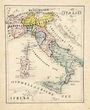 Antique Manuscript Map-ITALY-SICILY-Van Bommel-1863
-
$695.00
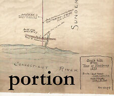
 Original Lake Wallenpaupack Area Map Hand Drawn Property Map From 1950
-
$50.00
 North Meadows Cemetery detailed Map ca 1922 Greenfield MA
-
$21.00
 Vintage WALWORTH, Wisconsin Walworth Township Area Map - 16" x 20" matted print
-
$90.00
 Montague-Leverett 1896 Map Town Line Survey Massachusetts - eb-108
-
$1347.50
 1790, SURVEYORS MAP, WILL COCKBURN, NY, LINWOOD, THOMAS TILLOTSON f VAN ETTEN
-
$90.00
 Greenfield Massachusetts map 1852 - traced in 1930s - EB 261
-
$45.00
 Ashfield Colonial Lotting Plan Map Massachusetts ca 1920 tracing eb-251
-
$120.00
 Greenfield Mass 1895 wall map ORIGINAL- top roller only Massachusetts - eb-408
-
$40.00
 Millers Falls 1923 Linen Map - eb 253
-
$145.00
 1907 BROOKLYN OLD MAP GRAVESEND | HARWAY BASIN CONEY ISLAND CREEK AVE V X W Y Z
-
$194.50
 Unique Manuscript Map-NORTH AMERICA-ROCKY MOUNTAINS-RANGE-Dumont-1865
-
$247.50
 Antique Manuscript Map-DENMARK-ICELAND-Van Bommel-1865
-
$258.50
 Antique Style Nautical Brass Engraved Globe Vintage Sphere Armillary Marine Item
-
$40.00
 Greenfield Massachusetts ca 1915 original street map - eb-27
-
$164.85
 1907 MIDWOOD OLD BROOKLYN CITY MAP CONEY ISLAND AVE PARKWAY DRIVING CLUB AVE Q-U
-
$9999.00
 1856 BURRITT'S "THE CONSTELLATIONS" Complete Set of 4 GEOGRAPHY OF HEAVENS ATLAS
-
$200.00
 Rowe Massachusetts Tax Map worksheets ca 1965 genaealogy eb-357
-
$50.00
 Map of Millers Falls City c 1870 Towns of Montague & Erving Massachusetts EB 236
-
$155.00
 1908 OLD BROOKLYN AUTHENTIC MAP | SUNSET PARK PLATE 34 | 4-9th Ave 38th-60th +++
-
$162.00
 1908 OLD BROOKLYN AUTHENTIC ORIGINAL MAP | INSTITUE & PROSPECT PARK PLATE 36
-
$273.74
 1866 EUROPE manuscript map by pupil W. Mulvey Brunswick House School Offord Rd
-
$49.99
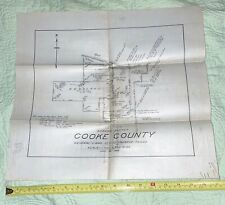 Cooke County Texas 1928 Working Sketch Linen Map by Architect John Menifee
-
$40.00
 Bernardston MA Map 1795 tracing on tissue..circa 1910 - eb-22
-
$100.00
 Original Shelburne MA map 1895 homeowner names - eb 256
-
$79.99
 antique hand colored Glocester RI map/ survey capt potter farm r.s. mowry 1895
-
$297.50
 Antique Manuscript Map-BRITAIN-IRELAND-Van Bommel-1865
-
$207.50
 Antique Manuscript Map-EUROPE-GREECE-Van Bommel-1865
-
$187.50
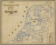 Antique Manuscript Map-TOPOGRAPHY-HYDROGRAPHY-NETHERLANDS-Bommel-1866
-
$187.50
 Antique Manuscript Map-FRIESLAND-GRONINGEN-DRENTHE-Anonymous-1860
-
$90.00
 1937 Map of Buckland MA - Ink on Linen - EB 230
-
$50.00
 C. 1868 Colored Atlas Map Of Montgomery Twp., Franklin Co., PA 15.5 x 27.25”
-
$50.00
 1914 Linen Map Prospect Hill School Lands - Greenfield, Massachusetts - EB211
-
$167.50
 1908 BROOKLYN CADASTRE MAP PLATE 28 | PARK SLOPE: PROSPECT PARK WINDSOR 1-16st
-
$500.00
 Original Map Of The Azores By Abraham Ortelius, 1573
-
$77.14
 Mid 19th Century hand drawn map "Egypt to Canaan by Jane Edwards Xmas 1860"
-
$194.50
 Unique Manuscript Map-SPAIN-PORTUGAL-MOUNTAIN RANGE-Dumont-1865
-
$207.50
 Antique Manuscript Map-PORTUGAL-EUROPE-Van Bommel-1865
-
$147.35
 1908 OLD BROOKLYN ANTIQUE CADASTRAL MAP | CYPRESS HILLS EAST NEW YORK | FULTON +
-
$595.00
 C 1720S RARE EAST RYDING YORKSHIRE MANUSCRIPT MAP ON VELLUM RYSAM GARTH
-
$162.35
 1907 GRAVESEND OLD BROOKLYN CITY MAP CONEY ISLAND & STILLWOOD CREEK E5th - W9TH
-
$14.95
 1953 Original Map Los Angeles Population Density
-
$435.49
 Bledington Gloucestershire c.1820 Surveyor's Hand Drawn Estate Plan on Vellum
-
$31.11
 1942 43 ww2 OLD map of DARLINGTON
-
$79.99
 1923 ROAD MAP OF VANCOUVER ISLAND VICTORIA AND DISTRICT BLUE PRINT & MAP Co
-
$18.66
 Original Map of River Thames Staines to Hampton Wick 1950 9.25" x 5"
-
$20.00
 Flood Hazard Study Terrapin Creek And Teributaries In Vicinity Of Piedmont...
-
$25.00
 Ca. 1790 child’s drawn map of the Americas likely English or Canadian
-
$80.00
 1916 Manuscript - Ink on Linen - Northfield, Mass EB-209
-
$40.00
 Greenfield Massachusetts 1952 street map hand drawn on Linen original eb-258
-
$163.65
 1907 MIDWOOD BROOKLYN VINTAGE MAP | WASHINGTON CEMETERY RR AVENUE I J K L M ++
-
$444.87
 Antique Paper Fabric Map of the AMERICAN CONTINENT c.1831+
-
$180.00
 Greenfield MA 1915 original linen map street names massachusetts EB221
-
$22.00
 A 1900s Nelson County Nd. Plat Book cloth pages,maps, North Dakota townships
-
$155.00
 1908 NY BROOKLYN MAP | BUSHWICK GREENPOINT WILLIAMSBURG | VINTAGE WALL ART
-
$168.00
 1907 BROOKLYN OLD MAP BENSONHURST BOROUGH PARK | 58th- 72nd St, 14th -21st Av ++
-
$169.00
 1907 BROOKLYN OLD MAP PLATE 16 PROSPECT PARK FLATBUSH KENSINGTON WINDSOR TERRACE
-
$31.11
 Original Map of River Thames Purley via Reading to Wargrave 1950 9" x 6"
-
$350.00
 CIRCA 1890 BOWERY BAY LONG ISLAND ASTORIA DITMARS STEINWAY HAND DRAWN MAP PLAN
-
$149.95
 1908 NY MAP | BROOKLYN NAVY YARD, WILLIAMSBURG | WALLABOUT CANAL NAVAL HOSPITAL
-
$154.98
 1907 BROOKLYN OLD MAP | FLATBUSH KENSINGTON OCEAN PARKWAY DITMAS CONEY ISLAND+
-
$31.11
 Original Map of River Thames Cirencester to Northmoor 1950 14" x 5.5"
-
$180.00
 Greenfield MA 1913 original linen map street names massachusetts EB220
-
$37.33
 vintage tourist map sydney 1940s lovely pre opera house
-
$163.55
 1907 MIDWOOD BROOKLYN VINTAGE ATLAS MAP | OCEAN AVE PKWY CONEY ISLAND AVE +++
-
$24.99
 1937 Blueprint Map of 79 Union Street,Bordentown,N.J.Crosswicks St.
-
$161.80
 1907 BROOKLYN VINTAGE CATASTRAL MAP | BAYRIDGE DYKER HEIGHTS | 5th - 14th AV +++
-
$31.11
 Original Map of River Thames Wargrave via Maidenhead to Boveney 1950 10.5" x 6"
-
$77.14
 Mid 19th Century hand drawn map of "England & Wales by Jane Edwards Mid's 1860"
-
$31.11
 Original Map of River Thames Benson to Purley 1950 8.75" x 5"
-
$5.00
 1987 HUNGARY POCKET MAP-MAGYAR ORSZAG-EXCELLENT CONDITION
-
$163.22
 1908 OLD BROOKLYN ANTIQUE CADASTRAL MAP | BROWNSVILLE | EAST NEW YORK | CANARSIE
-
$31.11
 Original Map of River Thames Nuneham & Abingdon to Benson 1950 8" x 6"
-
$299.50
 Brohlgy 1915 plat map NYC Plate 23, Cooper Union Area, Hand Colored, 23" by 33"
-
$162.50
 1907 BROOKLYN OLD MAP BENSONHURST | 72nd - 86th st, 14th -21st Av, KINGS HIGHWAY
-
$147.00
 1908 BROOKLYN OLD MAP 32.5 x 22.5 PLATE 32 | GREENWOOD HEIGHTS SECTION 3 NY BAY
-
$155.00
 1908 NY BROOKLYN MAP | WINTHROP PARK GREENPOINT WILLIAMSBURG | VINTAGE WALL ART
-
$166.91
 1907 BROOKLYN VINTAGE MAP | EAST FLATBUSH FLATLANDS MIDWOOD NOSTRAND GLENWOOD ++
-
$155.00
 1908 NY BROOKLYN MAP | BEDFORD-STYVESANT BUSHWICK | VINTAGE ATLAS WALL ART
-
$123.18
 1845 Antique Map of Persia by A. Findlay mounted on cardboard with COA
-
$154.50
 1907 BROOKLYN OLD MAP BAY RIDGE FORT HAMILTON DYKER HEIGHTS | 3rd AVE MARINE AVE
-
$155.00
 1908 NY BROOKLYN MAP | EAST WILLIAMSBURG | VINTAGE WALL ART | Plate 15
-
$400.00
 Antique Map Of Persia By Frederick De Wit 1680 (27 3/4" X 24 1/2")
-
$124.00
 1844 Hand Drawn Survey Alexander Wadsworth, Dana & Ellery Streets CAMBRIDGE MA
-
$12.44
 Original Small Antique Map 1885 - Eddystone Rocks 145mm x 115mm
-
$186.64
 1796 Georgian hand drawn map of land Bradfield Ecclesfield Sheffield
-
$373.28
 Antique map, MANUSCRIPT, Battle of Zorndorf (Sarbinowo Lubuskie, Poland), 1758
-
$374.50
 Unique Manuscript Map-WORLD-DOUBLE HEMISPHERE-MAPPE MONDE-Dumont-1865
-
$148.35
 1908 BROOKLYN CADASTRE MAP PLATE 24 BEDFORD-STYVESANT BROWNSVILLE CROWN HEIGHTS
-
$31.11
 Original Map of River Thames Northmoor to Oxford & Sandford 1950 7.25" x 5.25"
-
$37.33
 vintage map of brisbane queensland and places of interest australia
-
$4000.00
 Original Hand-Drawn Map of the Roman Empire 125 A.D.
-
$175.00
 1907 BOROUGH BROOKLYN VINTAGE MAP FORT HAMILTON DYKER HEIGHTS | 2nd- BAY 24th St
-
$165.00
 1908 NY BROOKLYN MAP | BEDFORD-STYVESANT BUSHWICK | VINTAGE WALL ART PLATE 20
-
$1250.00
 Original 1956 Pictorial Map Illustration of Oregon, Senator Wayne Morse Campaign
-
$137.00
 1908 BROOKLYN CADASTRE VINTAGE MAP WALL ART EVERGREEN CEMETERY BUSHWICK PLATE 22
-
$162.50
 Unique Manuscript Map-GREAT BRITAIN-ENGLAND-SCOTLAND-IRELAND-Dumont-1865
-
$162.50
 Unique Manuscript Map-ICELAND-DENMARK-FAROE ISLANDS-EUROPE-Dumont-1865


