-

$250.93
 1728 VERY RARE Herman Moll Map , Genuine Antique, The Persian Empire
-
$250.93
 1728 VERY RARE Herman Moll Map , Genuine Antique, Cyrus The Great Persia
-
$250.93
 1728 VERY RARE Herman Moll Map , Genuine Antique, Justin’s Map Of The World
-
$313.66
 1728 VERY RARE Herman Moll Map , Genuine Antique, Voyage Of Aeneas Greece
-
$14.00
 1900 Meyers Map North Italy Rome Florence Venice Milan Pisa Genoa Verona Alps
-
$15.99
 1896 Andrees Map Switzerland Slps Geneva Zurich Lucern Basel Bern Bodensee Lake
-
$9.99
 1889 Hughes Map - Physical Germany Bavaria Alps Danube Austria Baltic Sea Europe
-
$11.99
 1835 Map x 2 - Europe Political & Physical - Austria Italy Spain Britain
-
$15.99
 1885 Drioux Map - Physical Germany Napoleon Era - Leipzig Bautzen Berlin
-
$181.93
 Antique Map "Hispaniae Descriptio" (Spain-Portugal) S.Munster, 1550
-
$19.99
 1880 Berghaus Map Physical Central Europe Germany Austria Switzerland Alps
-
$9.99
 1904 Wagner Debes Map - Terni Papigno Peidiluco Mamore Collestatte Umbria Italy
-
$25.08
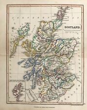
 1804 Antique Map; Scotland by John C. Russell
-
$313.66
 1728 VERY RARE Herman Moll Map , Genuine Antique, Syria And Assyria
-
$250.93
 1728 VERY RARE Herman Moll Map , Genuine Antique, Voyage Of Aeneas Greece
-
$200.74
 RARE Antique Map , W Pinnock , 1833 , NEW PLAN OF LONDON , Large A2 SIZE
-
$11.99
 1885 Drioux Map Physical Europe Germany Austria Hungary Empire Switzerland Alps
-
$250.00
 1849 Traveler's Map of West Prussia on Cloth, Handtke, Druck & Verlag, Flemming
-
$19.99
 EASTERN HEMISPHERE ASIA EUROPE AFRICA AUSTRALIA ARCTIC 1880 COLORED COLTON'S MAP
-
$195.00
 1780 Kingdoms of England Scotland & Ireland antique map by Bonne/Lattre - framed
-
$65.00
 1767 British Isles / England antique map by Clouet ~ 22.7" x 16.7" - hand color
-
$15.99
 1871 Guyot Physical Map Germany Austria Hungary Holland Polland Bohemia Russia
-
$11.99
 1892 Stieler Map Germany Strassburg Metz Frankfurt Coblenz Speyer Stuttgart Ulm
-
$12.00
 1897 BAEDEKER MAP - Germany Hamburg & Environs
-
$11.99
 1885 Cortambert Map - Physical France - Seine Rhone River Basin Pyrenees Alps
-
$9.88
 Monmouth England 1892 Antique Map R.S. Peale 9th Edition Encyclopedia Britannica
-
$31.37
 1910 map of Switzerland. Visperthal. 1:50000. Topographischer. Schweiz Bern
-
$34.95
 1975 Bartholomew & Son Clan Map Scotland Scottish 30" x 40" Poster Coats of Arms
-
$313.66
 1728 VERY RARE Herman Moll Map , Genuine Antique, Lybia Libya
-
$313.66
 1728 VERY RARE Herman Moll Map , Genuine Antique, GREECE
-
$69.00
 Original Antique 1780 Map of Europe by Bonne
-
$91.58
 RARE Antique Map , J Archer, 1832 , England , Isle Of Wight
-
$5.00
 1896 Map of Sweden and Norway original antique print
-
$17.76
 Europe Physical Map 1947 Vintage Color 16.5in by 12in ready to frame for art
-
$62.72
 1648 Antique Map; N.E. England: Eboracum, Lincolnia, Derbia... by Mercator
-
$16.00
 1885 Drioux Map France Physical River Basins Seine Rhone Loire Garonne Var Orne
-
$15.99
 1900 Times Map Switzerland Geneva Zurich Lucern Lake Constance Swiss Alps Italy
-
$29.43
 1922 PHYSICAL MAP OF GREAT BRITAIN SCOTLAND WALES IRELAND MOUNTAINS RIVERS
-
$313.66
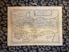 1728 VERY RARE Herman Moll Map , Genuine Antique, Greece Asia Minor
-
$58.50
 Physical & Hydrographical Map of France River Systems Loire 1849 Thierry map
-
$237.00
 1798 Map of Switzerland, Lake Geneva, Antique Linen
-
$18.00
 1896 ORIGINAL ANTIQUE PHYSICAL MAP OF ALPS ITALY AUSTRIA ISTRIA TYROL
-
$140.00
 1850s French Map of the Crimean War, with Detailed Views, Sevastopol, Ukraine
-
$15.00
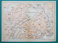 1897 BAEDEKER MAP - Germany HAMBURG City Plan + Railroads
-
$18.00
 1925 VINTAGE PHYSICAL MAP OF SCOTLAND
-
$20.00
 Map Toulouse Garonne Southern France Rare 1914 Lithograph WW1 Era WHBS
-
$11.99
 1900 Meyers Map Salzburg Austria Alps Germany Berchtesgaden Hallein Hallstatt
-
$20.00
 Map Nice Mediterranean #2 Southern France Rare 1914 Lithograph WW1 Era WHBS
-
$27.99
 1887 Andrees Map - Austrian Alps Salzburg Tirol Austria Italy Venice Switzerland
-
$18.94
 1907 ORIGINAL ANTIQUE PHYSICAL MAP OF FRANCE / CLIMATE AGRICULTURE
-
$18.00
 1888 ORIGINAL ANTIQUE MALTE-BRUN PHYSICAL MAP OF BAVARIA BAYERN MUNICH GERMANY
-
$18.00
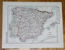 1907 ANTIQUE MAP OF SPAIN AND PORTUGAL BALEARIC ISLANDS MAJORCA ENGLAND PHYSICAL
-
$24.00
 Map Nice Mediterranean Sea Southern France Rare 1914 Lithograph WW1 Era WHBS
-
$30.00
 1795 Guthrie Ireland - 9.2" x 8.2" Authentic & original antique map
-
$18.94
 1906 ORIGINAL ANTIQUE PHYSICAL MAP OF FRANCE / BELGIUM
-
$18.00
 1901 ANTIQUE PHYSICAL MAP OF EUROPE MOUNTAINS RIVERS
-
$18.94
 1940 ORIGINAL VINTAGE WWII PHYSICAL MAP OF ALPS / SWITZERLAND ITALY
-
$9.99
 1849 Bilder Atlas Map - Switzerland - Lucern Geneva Zurich Berne - Swiss Alps
-
$14.50
 Antique Map: Geneva, Lausanne, Switzerland, Lac Leman - 1898
-
$27.99
 1901 Andrees Map S. France French Riviera Marseille Corsica Monaco Lyon Bordeaux
-
$18.00
 1904 ORIGINAL ANTIQUE PHYSICAL MAP OF EUROPE / MOUNTAINS RIVERS
-
$12.53
 1900 Gall & Inglis / Cary: Dumfries District Map, Scotland
-
$31.35
 1820 Antique Map; Scotland by A. Wright, published by Oliver & Boyd
-
$25.72
 1897 BAEDEKER MAP - Germany HAMBURG & ALTONA Good for Genealogy
-
$26.39
 1969 Adriatic Sea Taunton Nautical Chart Map Italy Albania & Yugoslavia 1440 Map
-
$18.94
 1928 VINTAGE PHYSICAL MAP OF EUROPE RUSSIA GERMANY FRANCE MOUNTAINS RIVERS
-
$188.21
 Map "Danish Islands in the Northern Atlantic Ocean" (Iceland) Fullarton, 1855
-
$9.99
 1877 Vuillemin Map Switzerland Zurich Lucern Geneva Berne Swiss Alps Mt Blanc FR
-
$19.99
 TWO PAGE UNITED STATES w NATIVE ANIMALS ENGRAVING 1880 COLORED COLTON'S MAP
-
$35.00
 1860 Austrian Empire Italian States & more antique map by Mitchell 15.3" x 12.3"
-
$45.00
 Antique Map SWITZERLAND 1864 Engraved & Hand Colored~From Johnson & Ward Atlas
-
$19.99
 1921 Johnston Map Netherlands Belgium Luxemburg Holland Amsterdam Brussels Ghent
-
$16.00
 Map Aix-Les-Bains Southern France Rare 1914 Lithograph WW1 Street Mini DWAA20B
-
$31.98
 Bernese Oberland Swiss Alps Foldout Map 1930s Switzerland Vintage A.Trüb & Cie
-
$199.00
 1735 Saxony Germany antique map by Homann ~ 25" x 20" beautiful full color
-
$20.00
 Map Cannes To Monaco Southern France Rare 1914 Lithograph WW1 Topo Mini DWAA20B
-
$11.99
 1875 Lange Map - North Germany - Brandenburg Berlin Breslau Meklenburg Sachsen
-
$9.99
 1880 Stieler Map Physical Europe Germany Austria Switzerland Italy France Alps
-
$18.81
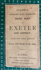 1900 Gall & Inglis / Cary: Eland's Cycling & Touring Road Map, Exeter & District
-
$106.59
 Robert Morden Antique Map East Riding Yorkshire York Beverley Hand Colour 1695
-
$79.20
 c 1650 MERIAN Antique Map Blavet River Port Louis Citadel Fort Brittany France
-
$16.00
 Map Limoges Southern France Rare 1914 Lithograph WW1 Street Mini Sheet DWAA20A
-
$15.99
 1875 Lange Map Netherlands Holland Belgium Denmark Amsterdam Copenhagen Brussels
-
$28.00
 Map Corsica Island Southern France Rare 1914 Lithograph WW1 Era WHBS
-
$18.95
 Old Map Murray's Handy Classical Map of Gallia with Index abb
-
$16.00
 Map Beziers Southern France Rare 1914 Lithograph WW1 Street Mini Sheet DWAA20A
-
$20.00
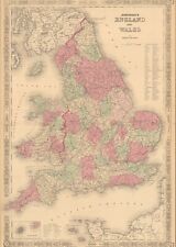 1864 England & Wales by Johnson Ward beautiful antique map 25.8" x 17.6"
-
$16.60
 circa 1930 Italian Railway Map; Carta Ferroviaria D’Italia, Zuegg Publishers
-
$30.00
 1876 Austria & Scandinavian Kingdoms antique map ~ 19.6" x 14.2" hand colored
-
$8.98
 France - 1940s Atlas Map -
-
$31.99
 1859 Gall & Inglis Map Spain Portugal Madrid Barcelona Lisbon Gibraltar Santiago
-
$20.19
 1896 ANTIQUE PHYSICAL MAP OF CENTRAL EUROPE GERMANY POLAND RIVERS MOUNTAINS
-
$9.99
 1874 Stieler Map - Europe Alps - Switzerland Germany France Basel Neuchatel Lake
-
$16.00
 Map Carcassonne Southern France Rare 1914 Lithograph WW1 Street Mini DWAA20B
-
$16.00
 1849 Bilder Atlas Physical Map - Central Europe Rivers & Mountains Alps Rhein
-
$16.00
 Map Niort Southern France Rare 1914 Lithograph WW1 Street Mini Sheet DWAA20A
-
$16.00
 Map Bourg Southern France Rare 1914 Lithograph WW1 Street Mini Sheet DWAA20B
-
$335.00
 CAPT FYERS Personal 1854 "THE CRIMEA" Fold Out Hand Colored MAP -John Arrowsmith
-
$112.91
 RARE Antique Map , W Pinnock , 1832 , , England , Berkshire
-
$250.93
 1728 VERY RARE Herman Moll Map , Genuine Antique, EUROPE ASIA AFRICA


