 Antiques (US)
Africa Maps
Asia Maps
Australia/Oceania Maps
Celestial Maps
Central America/Caribbean Maps
Curiosities Maps
Digital Maps
Europe Maps
Map & Globe Mixed Lots
Map & Globe Reproductions
North America Maps
South America Maps
World & Celestial Globes
World Maps

-
$60.00

 St. Louis Missouri City Plan Mississippi River 1853 scarce hand colored map
-
$100.00
 Chao Phraya River Thailand Siam Bangkok Menam River 1752 Bellin hand color map
-
$60.00
 Pittsburgh Pennsylvania City Plan Allegheny River 1853 scarce hand color map
-
$31.70
 1922 VINTAGE MAP OF EGYPT ALEXANDRIA SUDAN NILE RIVER ETHIOPIA ERITREA AFRICA
-
$29.99
 1879 MAP OF THE COUNTRY PENINSULA OF FLORIDA CONSTRUCTION OF A SHIP CANAL MAP!
-
$29.99
 1919 ST. JOHNS RIVER FLORIDA JACKSONVILLE TO TROUT CREEK SHOWING OWNERSHIP MAP!
-
$19.99
 1919 TAMPA HARBOR FLORIDA HILLSBORO BAY SHOWING WATER TERMINALS & TRANSFERS MAP!
-
$27.11
 THE RHINE (1964) Fold-Out Historical Map, German River, Germany, 42 x 7 Inches
-
$15.99
 Map United States West Lahontan Long River Senex Stansbury 1852
-
$19.99
 1920 TERMINAL FACILITIES PORT OF ASTORIA OREGON SHOWING THREE PIERS MAP!
-
$121.15
 1873 Plat Map CHARLES & MILLERS RIVER - B & L RAILROAD YARD, CAMBRIDGE, MA 14x17
-
$35.00
 RIO SAN GABRIEL, CALIFORNIA, FROM EMORY. 1848, MEXICAN WAR, CALIFORNIA.
-
$19.99
 1914 THE DELTA OF COLORADO RIVER SALTON SEA & IMPERIAL VALLEY COLOR MAP!
-
$54.40
 Canada East Quebec Montreal Quebec City Three Rivers 1860 Mitchell map
-
$60.00
 Gloucestershire England Cheltenham River Tewksbury c.1840's decorative map
-
$48.00
 Quebec Canada Montreal Quebec City Three Rivers 1869 Mitchell hand color map
-
$9.99
 1915 BUFFALO HARBOR NY INNER HARBOR ENTRANCE CHANNEL MAP 19.25 x 27!
-
$34.88
 1878 Blackfoot Basin Idaho Map Soda Springs Georgetown Bear River EXPLORATION
-
$10.00
 1883 SURVEY MAP-RAPPAHANNOCK RIVER, VA-FREDERICKSBURG BAR-US CORPS OF ENGINEERS
-
$35.00
 1908 George Walker Hudson River District Linen Automobile Map
-
$9.99
 1916 MUSKINGUM RIVER BASIN OHIO ENGINEERING MAP!
-
$12.00
 Large 1882 Antique Map: Mississipi River Delta to Memphis 13
-
$69.99
 1920 NEW YORK HARBOR N.Y. WATER TERMINAL & TRANSFER FACILITIES MAPS 5 MAPS!
-
$4.00
 1897 ANTIQUE SURVEY MAP-CALCASIEU RIVER & PASS, LOUISIANA-US CORPS OF ENGINEERS
-
$9.99
 1911 BRONX RIVER NEW YORK ENGINEERING MAPS 2 MAPS!
-
$9.99
 1914 INLAND WATERWAY FROM NORFOLK VA. TO BEAUFORT INLET N.C. MAP 13.25 x 20.75!
-
$34.88
 1898 STERLING ILLINOIS Map ORIGINAL LOCKS AND DAMS Rock Falls Canal
-
$9.99
 1913 DRAINAGE BASIN OF THE MISSISSIPPI RIVER COLOR MAP 12 x 17!
-
$73.99
 1882 Map of the Rovuma River Tanzania Mozambique antique vintage
-
$39.64
 1922 VINTAGE MAP OF LOWER EGYPT SUDAN NILE RIVER CAIRO SUEZ CANAL AFRICA
-
$49.60
 Washington Territory Seattle Walla Walla Columbia River c. 1890 Watson map
-
$76.00
 Dublin Ireland 1874 detailed City Plan River Liffey Black uncommon map
-
$17.50
 Rhein River Germany Panorama Mainz to Coeln by G Blumlein & Co? 1800's Map
-
$9.99
 1916 SHOALS IN POINT JUDITH HARBOR RHODE ISLAND ENGINEERING MAP!
-
$9.99
 1916 INLAND WATERWAYS BEAUFORT HARBOR-NEW RIVER & SWANSBORO-NEW RIVER N.C. MAP!
-
$19.99
 1919 NORFOLK HARBOR VIRGINIA WATER TERMINALS ENGINEERING MAP 22 x 30.50!
-
$19.99
 1910 SEA LEVEL PROJECT BETWEEN PAMLICO SOUND AND BEAUFORT INLET N.C. GENERAL MAP
-
$12.33
 1882 Map of Marhatta Country Bombay Mumbai India antique vintage
-
$52.00
 Montague Athol Ct. river Northfield Franklin Massachusetts 1891 Walker map
-
$60.00
 Cape Fear River Frying Pan Shoals North Carolina 1851 U.S. Coast Survey map
-
$9.99
 Vintage Map "Spain and Portugal" & "A Map of the mouth of the River Tagus" 1756
-
$29.99
 1890 MISSOURI RIVER SHOWING LAND ERODED BETWEEN 1879 AND 1890 COLOR MAP!
-
$9.99
 1911 INTRA-COASTAL WATERWAY ANCLOTE RIVER TO SOUTH END CLEARWATER HARBOR FL MAP
-
$17.99
 1875 Warrens Report Wisconsin River Map Ghost Town Richland City Spring Green
-
$18.00
 1877 Petermann Map Arctic Exploration Siberia Russia Ob River to Kara Sea Route
-
$15.99
 Two Maps Florida Key West St. Johns River Surveys 1896 Free Ship
-
$19.99
 1920 BALTIMORE HARBOR MARYLAND TERMINALS W/WIND CHART ENGINEERING MAP 22 x 30.50
-
$9.95
 1896 CIVIL WAR OFFICIAL RECORDS ATLAS MAP-SOUTH SIDE OF THE JAMES RIVER, VA-P 93
-
$9.99
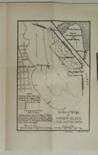 1916 HARBOR OF REFUGE AT HARBOR BEACH LAKE HURON MICHIGAN MAP!
-
$49.99
 Vintage 1967 Reproduction of 1858 Map of the Plantations along Mississippi River
-
$9.99
 1911 NEW BEDFORD & FAIRHAVEN HARBORS MASS. EXTENDING TO BELLEVILLE WHARF 2 MAPS!
-
$58.00
 1877 WYOMING Map ORIGINAL Green River Basin Rocky Mountains Bitter Root
-
$9.99
 1915 BUFFALO HARBOR NEW YORK PROPOSED DEEPENING OF OUTER HARBOR MAP 18 x 21!
-
$9.99
 1913 MILL CREEK VIRGINIA ENGINEERING MAP 9 x 15.25!
-
$9.99
 1909 MAP OF DAM SPILLWAY SITE ON TALLAPOOSA RIVER NO. 1 AT CHEROKEE BLUFFS AL.!
-
$17.00
 Oldenburg & the Weser River Basin - Original 1888 Map by Meyers. Germany
-
$9.99
 1916 HUDSON RIVER CHANNEL NEW YORK HARBOR NY ENGINEERING MAP 18.50 x 26.75!
-
$10.00
 1884 BEAUTIFUL ENGINEERING ANTIQUE ATLAS MAP OF MISSOURI RIVER AT ST. JOSEPH
-
$9.99
 1915 SHREWSBURY RIVER NEW JERSEY SHOWING SAND SPIT BETWEEN RIVER AND OCEAN MAP!
-
$25.00
 1927 VINTAGE ORIGINAL HUDSON RIVER DAY LINE NEW YORK - ALBANY TRAVELOGUE / MAP
-
$13.00
 1943 Vintage Map - Memphis to the Gulf - US Civil War - Mississippi River LA AR
-
$9.99
 1913 NIAGARA RIVER NEW YORK PROPOSED 23-FOOT CHANNEL ENGINEERING MAP 17 x 27!
-
$10.00
 1884 BEAUTIFUL ENGINEERING ANTIQUE ATLAS MAP OF MISSOURI RIVER AT KANSAS CITY
-
$10.00
 1888 BEAUTIFUL ENGINEERING ANTIQUE ATLAS MAP-MISSISSIPPI RIVER-PLUM POINT REACH
-
$9.99
 1914 ENTRANCE TO COOS BAY OREGON ENGINEERING MAP 17 x 35!
-
$9.99
 1911 CALUMET RIVER DISTRICT ILLINOIS AND INDIANA ENGINEERING MAP 23.50 x 34.50!
-
$28.76
 Vintage 1902 NEW JERSEY Map 14"x22"~ Old Antique Original CAPE MAY TOMS RIVER NJ
-
$9.99
 1916 LAKE SUPERIOR AND MISSISSIPPI CANAL AMNICON MOOSE AND ST. CROIX ROUTE MAP!
-
$48.88
 1939 Buffalo New York Map Niagara River Downtown Railroads Delaware Park
-
$29.99
 Map of Louisiana & Mississippi River by John Senex Antique 1721 Reprint
-
$9.99
 1916 NEW RIVER ONSLOW COUNTY NORTH CAROLINA PORTION NEAR MOUTH MAP 18.75 x 26.25
-
$6.17
 1909 map of St Mary's River Michigan Ontario antique vintage Baedeker
-
$9.99
 1912 WESSAWESKEAG RIVER SOUTH THOMASTON MAINE WAR DEPARTMENT ENGINEERING MAP!
-
$9.99
 1910 LARCHMONT HARBOR NEW YORK ENGINEERING MAP 21.50 x 31!
-
$9.99
 1916 MYSTIC RIVER MASSACHUSETTS FROM MOUTH OF ISLAND END RIVER TO MEDFORD MAP!
-
$44.88
 1898 DUBLIN Ireland Map Liffey River College Park Merrion Square Steam Railroads
-
$19.99
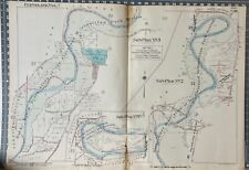
 1910 LITTLE KANAWHA RIVER FROM BURNSVILLE TO POOL NO. 5 PROFILE MAPS 3 MAPS!
-
$44.88
 1898 Mississippi River Map Missouri Illinois Powers Island Burnham Island
-
$225.00
 1787 PF Tardieu Ohio River Tributary Maps Muskingum Beaver Sioto Indian Villages
-
$9.99
 1916 NEWARK BAY NEW JERSEY ENGINEERING MAP 18.25 x 27.75!
-
$19.99
 1912 SAVANNAH HARBOR GEORGIA SHOWING OWNERSHIP OF WHARF PROPERTY MAPS 3 MAPS!
-
$39.99
 1913 GRAYS HARBOR WASHINGTON ENGINEERING MAPS 10 MAPS 9 x 9.50!
-
$9.99
 1912 CHARLOTTE HARBOR FLORIDA ENGINEERING MAP 18.25 x 25!
-
$9.99
 1913 LITTLE KANAWHA RIVER FROM LOCK NO. 5 TO BURNSVILLE WEST VIRGINIA MAP!
-
$9.99
 1916 PEARL RIVER MISSISSIPPI AND LOUISIANA ENGINEERING MAP 7.25 x 15.75!
-
$15.99
 River Systems of the United States (Rivers) - A STUNNING 1947 Post War Map
-
$78.40
 Berlin Germany City Plan Spree River c. 1850's Heck fine hand color engraved map
-
$9.99
 1911 HILO HARBOR HAWAII ENGINEERING MAP 23 x 29!
-
$9.99
 1917 WATERSHED COLORADO RIVER TEXAS ENGINEERING MAP 11.75 x 15.50!
-
$12.99
 1914 MINNEAPOLIS HARBOR MISSISSIPPI RIVER ENGINEERING MAPS 2 MAPS 14.75 x 20.25!
-
$19.99
 1912 KAHULUI HARBOR MAUI T.H. HAWAII WAR DEPARTMENT ENGINEERING MAP!
-
$9.99
 1915 SHETUCKET AND QUINEBAUG RIVERS & FRENCH RIVER CONN. AND MASSACHUSETTS MAP!
-
$9.85
 Philpott Lake Smith River Bassett Virginia 1978 Map
-
$9.99
 War of 1812 Map Battle of Lundy's Lane or Niagara Falls River Chippewa Canada US
-
$9.99
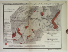 1900 MAP SHOWING DISTRIBUTION OF THE IRON ORES OF BARTOW POLK & FLOYD COUNTIES!
-
$9.99
 1912 COAL RIVER FROM MOUTH TO BOONE WEST VIRGINIA WAR DEPARTMENT ENGINEERING MAP
-
$9.99
 1910 COOSA RIVER GADSDEN ALABAMA TO WETUMPKA ALABAMA SHOWING LOCKS MAP!
-
$111.24
 Antique Civil War Map Mississippi River Rebel Fortifications Pope Campaign 1866
-
$52.00
 Rhaetia Gaul Rhine River Roman Empire Germania Border c. 1849 detailed Meyer map
-
$115.00
 1938 Cleveland Metroparks, Rocky River Reservation. original antique map


