-

$123.32
 2 Framed Webster Prints Map of River Thames c1760 55x27cm
-
$18.68
 STANFORD'S MAP OF THE RIVER THAMES 1961
-
$31.23
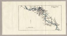
 Original Map of River Thames Northmoor to Oxford & Sandford 1950 7.25" x 5.25"
-
$31.23
 Original Map of River Thames Benson to Purley 1950 8.75" x 5"
-
$281.09
 Johnson's Mountains Rivers. Africa, Asia, Europe, South & North America 1866 map
-
$9.95
 ORIGINAL 1888 ANTIQUE COLOR MAP LOT - WORLD WINDS RAIN TEMPERATURE RIVER BASIN'S
-
$34.99
 1834 Carey Map World Rivers Amazon Mississippi Nile Danube Rhine Thames Orinoco
-
$14.39
 1886 Antique COLOR Map/Print///RIVER ENGINEERING
-
$79.99
 1834 Carey Miniature World Map North South America Europe Africa Asia Australia
-
$32.48
 WORLD TWIN HEMISPHERES. Relief. Mountains. Rivers. JOHNSTON 1900 old map
-
$12.95
 Atlas du Canada Maps and Info 1912 French Rand McNally
-
$7.99
 ANTIQUE 1888 WESTERN HEMISPHERE WORLD MAP RIVER LENGTH MOUNTAIN GLOBULAR FINE
-
$32.48
 WORLD TWIN HEMISPHERES. Relief. Mountains. Rivers. JOHNSTON 1906 old map
-
$31.23
 Original Map of River Thames Boveney via Windsor to Staines 1950 8.5" x 5"
-
$31.23
 Original Map of River Thames Wargrave via Maidenhead to Boveney 1950 10.5" x 6"
-
$31.23
 Original Map of River Thames Nuneham & Abingdon to Benson 1950 8" x 6"
-
$149.92
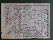 ANTIQUE ST.LAWRENCE RIVER LAKE ONTARIO ORIGINAL 1759 THOMAS KITCHIN MAP 11"x8"
-
$7.99
 ANTIQUE 1900 EASTERN HEMISPHERE MAP ASIA AUSTRALIA AFRICA MOUNTAIN RIVER SUPERB
-
$7.99
 ANTIQUE 1858 WORLD RIVER BASIN HANDCOLORED MAP ASIA UNITED STATES AUSTRALIA NR
-
$12.49
 WORLD IN HEMISPHERES. Relief. NSEW. Land & Water. River lengths 1920 old map
-
$12.48
 c1900 Collins World Map Rivers Mountains Siam Formosa Antique Map
-
$437.26
 Rare 1628 Map by Willem Janszoon Blaeu Elbe River Germany
-
$18.74
 Original Map of River Thames Staines to Hampton Wick 1950 9.25" x 5"
-
$16.50
 #39262 Vintage map of Tanscaspian Depression. Royal Geogr.Society England 1898.
-
$38.73
 WORLD TWIN HEMISPHERES. Relief. Mountains. Rivers. JOHNSTON 1895 old map
-
$16.50
 #39259 Vintage map - the River Barima,S.America.Royal Geogr.Society England 1895
-
$31.23
 Original Map of River Thames Purley via Reading to Wargrave 1950 9" x 6"
-
$37.48
 THE WORLD IN HEMISPHERES. River lengths Mountain heights. BARTHOLOMEW 1876 map
-
$61.16
 1866 Mackenzie Antique Twin Hemisphere World Map, Mountains, Rivers, Trade Winds
-
$31.23
 Original Map of River Thames Cirencester to Northmoor 1950 14" x 5.5"
-
$93.70
 WORLD IN HEMISPHERES, original antique map on two sheets, SDUK c.1858
-
$49.97
 Original antique map / chart of the WORLD'S LONGEST RIVERS, Buchon, 1825
-
$16.50
![#39260 Vintage map of the Luchy Island [Asia]. Royal Geogr.Society England 1895.](https://i.ebayimg.com/thumbs/images/g/kWEAAOSwDYNdh6vW/s-l225.jpg) #39260 Vintage map of the Luchy Island [Asia]. Royal Geogr.Society England 1895.
#39260 Vintage map of the Luchy Island [Asia]. Royal Geogr.Society England 1895.
-
$16.50
![#39255 Vintage map of Athabasca River [Canada]. Royal Geogr Society England 1894](https://i.ebayimg.com/thumbs/images/g/sjUAAOSw31ldh6lP/s-l225.jpg) #39255 Vintage map of Athabasca River [Canada]. Royal Geogr Society England 1894
#39255 Vintage map of Athabasca River [Canada]. Royal Geogr Society England 1894
-
$118.68
 WORLD RIVERS. Comparative lengths of principal rivers. Countries.SDUK 1844 map
-
$20.00
 1932 ORIGINAL COLOR MAP of NILE RIVER VALLEY Africa ~ Authentic Dated Vintage
-
$30.00
 DISCOVERY AND EXPLORATIONS OF THE ST JOSEPH RIVER NEW GUINEA 1887 MAP
-
$95.00
 1860 The World in Hemispheres & River Size Comparison Mitchell Map Atlas
-
$145.00
 Great World Rivers, original antique map SDUK 1834
-
$19.98
 Antique c1904 colour Map Natal Transvaal & Orange River County HARMSWORTH ATLAS
-
$106.19
 Comparative lengths of World's PRINCIPAL RIVERS. Amazon longest. SDUK 1857 map
-
$31.23
 'Principales Rivi�res du globe'. World's longest rivers. BUCHON 1825 old map
-
$22.49
 Large Vintage Admiralty Map/Sea Chart England West Coast River Severn Avonmouth
-
$93.70
 Comparative lengths of principal WORLD RIVERS. SDUK 1844 old antique map chart
-
$110.00
 Dual Hemisphere World Map c 1853 , with N/S Poles, Comparative Rivers/ Mts.
-
$88.70
 World in twin Hemispheres. Mountains and Rivers. BARTHOLOMEW 1870 old map
-
$187.40
 World major rivers comparative lengths. Snowline at different latitudes 1817 map
-
$125.00
 1856 MAP River Systems Ocean Currents Cartee's Geography Hickling Swan & Brown
-
$22.50
 #39269 Vintage map,North-central Sze Chuan,China.Royal Geogr.Society England1897
-
$281.09
 WESTERN HEMISPHERE.Falls rivers mountains.No Mt McKinley.TALLIS/RAPKIN 1851 map
-
$281.09
 WESTERN HEMISPHERE.Falls rivers mountains.No Mt McKinley. RAPKIN/TALLIS 1851 map
-
$137.42
 Comparative lengths of PRINCIPAL RIVERS of the World. Countries. SDUK 1851 map
-
$343.56
 World in hemispheres. Mountains & rivers. SWANSTON 1860 old antique map chart
-
$22.50
![#39265 Vintage map of Kavirondo [Africa]. Royal Geogr.Society England 1898.](https://i.ebayimg.com/thumbs/images/g/PVQAAOSwOFFdh656/s-l225.jpg) #39265 Vintage map of Kavirondo [Africa]. Royal Geogr.Society England 1898.
#39265 Vintage map of Kavirondo [Africa]. Royal Geogr.Society England 1898.
-
$124.93
 EASTERN HEMISPHERE. Falls rivers mountains. No Everest. TALLIS & RAPKIN 1851 map
-
$90.87
 Antique Map 230-818 Gold Field map of Rocky River c.1860
-
$292.07
 Tallis map of Western Australia, Swan River, c1853
-
$139.55
 Antique Map 232-584 World Mountains and Rivers - height and length c.1855
-
$187.40
 Large Map Print of Between The Tay River and the Murray Firth Johan Blaeu 1654.
-
$124.93
 EASTERN HEMISPHERE. Falls rivers mountains. No Everest. TALLIS/RAPKIN 1851 map
-
$118.68
 WORLD RIVERS. Comparative lengths of principal rivers. Countries.SDUK 1844 map
-
$124.93
 EASTERN HEMISPHERE. Falls rivers mountains. No Everest. TALLIS & RAPKIN 1851 map
-
$48.68
 ASIA MAP / Asien Fluss-und Gebirgssysteme Asia Rivers and Mountain Systems 1908
-
$154.91
 EASTERN HEMISPHERE. Falls rivers mountains. No Everest. TALLIS/RAPKIN c1851 map
-
$220.68
 Antique map - China - Pay-Ho or White River c.1797 Ref# 232-863
-
$42.19
 Antique Map 236-013 Portugal - Oporto and River Douro in 1809, published c.1910


