 Antiques (US)
-
$22.63

 Antique Map FRANCE, Engraved by Fisk & Co, 1890- Inset of Corsica
-
$89.00
 Map Of The Sandwich Isles Cartographer's Notes By Artist Blaise Domino Signed 93
-
$139.50
 Antique Print-ARCHIPEL BOURBON-TAHITI-PAPARA-POLYNESIA-Krevelt-Bougainville-1772
-
$69.50
 Antique Print-ARCHIPELAGO-AKIAKI-POLYNESIA-ATOLL-Krevelt-Bougainville-1772
-
$19.99
 Map of the Sandwich Isles Hawaii by CARTOGRAPHER BLAISE DOMINO Matted Art Print
-
$28.00
 Map Of The Sandwich Isles, Cartographer's Notes By Artist Blaise Domino
-
$4.50
 Vintage Map of MILFORD New Zealand Topographical Map (1973 1st edition)
-
$43.16
 1784 ANTIQUE MAP CHART OF THE SOCIETY ISLES DISCOVERED BY CAPTAIN COOK 1769
-
$32.95
 PACIFIC OCEANIA NORTH SOUTH AMERICA COASTLINE STIELER ATLAS NO 76 1892 ORIGINAL
-
$21.00
 1844 ORIGINAL MAP - Australia Oceania Pacific Islands New Zealand Philippines
-
$15.00
 Vintage Australia 1965 US Army Topographic Map 1:5,000,000
-
$24.60
 1784 ANTIQUE COPPER ENGRAVING MAP - SOUTH PACIFIC ISLANDS WATEEOO ETC - COOK
-
$43.16
 1785 ANTIQUE MAP CHART SKETCH OF TONGATABOO HARBOUR - CAPTAIN COOK 1777
-
$21.90
 1897 ORIGINAL VINTAGE MAP Samoa Islands Meyers Konversations-Lexikon C10-5
-
$357.50
 1890 John Forrest Large Antique Folding Map of Western Australia Pastoral Leases
-
$18.48
 1886 map of new zealand .by rev george butler
-
$75.00
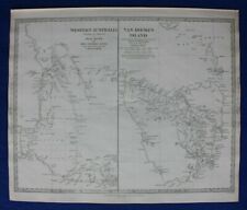
 Vintage Antique 1827 Map AUSTRALIA Polynesia- New Hollland, Van Diemens Land
-
$43.16
 1784 ANTIQUE MAP CHART NEW BRITAIN ENDEAVOUR STREIGHTS NEW GUINEA CAPTAIN COOK
-
$10.00
 NZTopo50-BP25 Motueka Map, topographic, New Zealand, Abel Tasman Nat Park, 2009
-
$10.00
 NZTopo50-AV29 Russell Map, topographic, New Zealand, Bay of Islands, 2009
-
$10.00
 NZTopo50-BX15 Fox Glacier Map, topographic, New Zealand, 2009
-
$10.00
 NZTopo50-BV20 Otira Map, topographic, New Zealand, 2009, Arthur’s Pass
-
$8.00
 Waitakere Ranges Regional Park Map, topo, New Zealand Aukland Regional Council
-
$10.00
 NZTopo50-CB09 Hollyford Map, topographic, New Zealand, 2009, Routeburn Track
-
$36.93
 1785 ANTIQUE MAP CHART OF THE FRIENDLY ISLANDS - TONGA - CAPTAIN COOK 1777 HOGG
-
$10.00
 NZTopo50-BY14 Mount Ward Map, topographic, New Zealand, 2009, Landsborough River
-
$10.00
 NZTopo50-CB12 Cardrona Map, topographic, New Zealand, 2009, Wanaka
-
$10.00
 NZTopo50-BJ34 Mount Ruapehu Map, topographic, New Zealand, 2009, Volcano
-
$36.99
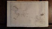
 PACIFIC OCEAN, POLYNESIA, original antique map SDUK 1844
-
$1802.08
 Rare 1891 Alexander Black Contour Map of Mornington Peninsula Victoria Australia
-
$49.26
 1870s Longman Australia and New Zealand Oceania Map Print Antique Hand Coloured
-
$46.86
 AUSTRALIA, NEW SOUTH WALES, QUEENSLAND, original antique map, Johnston, 1871
-
$34.99
 ANTIQUE HAND COLORED ENGRAVING MAP 1859 COLTON'S GENERAL ATLAS NORTHERN ITALY
-
$183.74
 1774 Carte de Cook Detroit dans la Nle. Zelande Bernard Reine Charlotte
-
$67.82
 c1850 Australia Tasmania Antique Map John Rapkin Van Diemans Island Explorers
-
$36.93
 1785 ANTIQUE MAP CHART CHRISTMAS ISLAND - CAPTAIN COOK 1777 HOGG / BOWEN
-
$1541.44
 Genuine antique map / panorama of SYDNEY / Australiaby Horace Harrall publ. 1879
-
$27.13
 Original antique map SOUTH EAST AUSTRALIA, NEW SOUTH WALES, Stieler, 1891
-
$59.19
 OCEANIA, PACIFIC, AUSTRALIA, NEW ZEALAND, original antique map, Johnston, 1871
-
$44.39
 Original antique map POLYNESIA, PACIFIC, FIJI, TONGA, AUSTRALIA, Stieler, 1886
-
$40.00
 Vintage 1974 IGN France Molded Plastic Tahiti Papeete Moorea School Map
-
$12.32
 Australia & Oceania Physical Map 1917 Prof Meiklejohn Bartholomew Atlas
-
$24.66
 Original antique map WEST AUSTRALIA, NEW ZEALAND, TASMANIA, Stieler, 1891
-
$12.32
 Australia & Victoria NSW Physical Map 1917 Prof Meiklejohn Bartholomew Atlas
-
$12.87
 JERILDERIE TOPOGRAPHIC VINTAGE MAP NEW SOUTH WALES australia
-
$36.98
 Van Diemens Land Tasmania Reproduction of Antique Engraving dated 1853 Framed
-
$34.53
 Original antique map WESTERN AUSTRALIA, NEW ZEALAND, TASMANIA, Stieler, 1886
-
$209.64
 NEW SOUTH WALES / Australia. Genuine antique map by A. K. Johnston ca. 1850s
-
$67.82
 WESTERN AUSTRALIA, VAN DIEMEN ISLAND, TASMANIA, original antique map, SDUK, 1844
-
$6.15
 AUSTRALIAN GEOGRAPHICAL MAP - ALBANY - 1st EDITION 1958
-
$2530.00
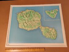
 Large Chart of the Gambier Islands, Tuamotu Archipelago, French Polynesia
-
$55.49
 c1855 Australasia Australia New Holland Cassells Unexplored Interior Antique Map
-
$193.08
 Pacific Ocean. 1855
-
$80.15
 Central/Western Australia antique map and report, Mackay, Terry, RGS Dec 1934


