 Antiques (US)
Anchors
Diving Helmets
Fishing Nets & Floats
Harpoons
Maritime Bells, Whistles & Horns
Maritime Blueprints
Maritime Cannons & Cannon Balls
Maritime Cleats & Chocks
Maritime Clocks
Maritime Compasses
Maritime Flags, Ensigns & Pennants
Maritime Folk Art
Maritime Lamps & Lighting
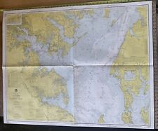
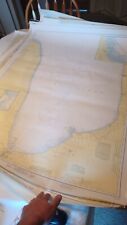
Maritime Navigational Charts
Maritime Navigational Instruments
Maritime Parallel Rules
Maritime Plaques & Signs
Maritime Portholes & Hatches
Maritime Price Guides & Publications
Maritime Propellers
Maritime Pulleys
Maritime Reproductions
Maritime Scrimshaw Replicas
Maritime Telegraphs
Maritime Telescopes
Maritime Wheels
Model Ships
Other Maritime Antiques

-
$41.95

 Massachusetts Geodetic Survey Map x 2 USC & GS Essex County WPA Vintage
-
$22.95
 Massachusetts Geodetic Survey Map USC & GS Essex County Haverhill Vintage
-
$58.48
 World War II Era (May 1943) Nantucket Sound & Approaches Nautical Map 8th Ed.
-
$450.00
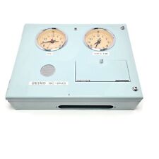 Seiko QC-6M3 Maritime Master Clock. 110/230/24 Volts. Made in Japan
-
$3.16
 Vintage nautical maritime sea flag navy signal license plate JDA plastic
-
$20.00
 Nautical Chart Catalog 2 Pacific Coast Hawaii Guam April 1979
-
$19.99
 Vintage Hydrographic Chart Bougainville Strait Solomon Islands 1940s WW2
-
$24.00
 C&GS Coastal Map - Chesapeake Bay - Mobjack Bay To York River #494 18th Ed. 1973
-
$9.95
 Five Vintage Seamanship/Navigation Booklets
-
$30.00
 C&GS Coastal Map - Chesapeake Bay Entrance #1222, 1973, 37th Edition 35”X 45”
-
$19.99
 Vintage Hydrographic Chart Savaii Samoa Islands 1928 with WW2 Revisions
-
$49.99
 Antique Copper Life-Lite Self Igniting US Coast Guard Rescue Light (B2C226C)
-
$199.00
 37 Nautical Signal Flags -Pennants, Letters & Numbers, Heavy Duty Stitched Nylon
-
$35.00
 Vintage San Diego Bay Nautical Chart #5107 1968 35x43
-
$49.99
 Antique Copper Life-Lite Self Igniting US Coast Guard Rescue Light (B2C227C)
-
$249.99
 Vintage Perko USCG Ships Masthead Light Converted to a Plug in Lamp ~ Free Ship
-
$22.00
 C&GS Coastal Map - New Jersey/Delaware- Cape May To Fenwick #12244 28th Ed. 1975
-
$40.00
 “1907” Catalog of charts, coast pilots, and the tide tables By Commerce Dept.
-
$19.99
 Vintage Hydrographic Chart San Pedro Bay California 1940s
-
$35.00
 C&GS Coastal Map. Head Of Chesapeake Bay #12274 13th Edition 1974
-
$19.99
 Vintage Hydrographic Chart Los Angeles Harbor Vicinity 1940s
-
$35.00
 C&GS Coastal Map - Baltimore Harbor Entrance #12278, 1974, 40th Edition 36”X 45”
-
$28.00
 C&GS Costal Map - Fenwick lsland Light -Chincoteague Inlet #12211, 1975, 22nd Ed
-
$20.00
 C&GS Coastal Map. Chesapeake Bay - Rappahannok River Ent. - #573 14th Ed. 1973
-
$28.00
 C&GS Coastal Map. Chesapeake Bay - Smith Point To Cove Point #1225 26th Ed. 1974
-
$21.69
 Nautical plotting Chat SALEM & LYNN MASS HARBORS VTG 1963 edition 36x 39
-
$125.00
 Vintage Signal Flag “R”
-
$99.99
 Antique Copper Life-Lite Self Igniting US Coast Guard Rescue Light (B2C209C)
-
$28.00
 FISHER ISLAND SOUND Nautical Chart C.& G.S. 358
-
$30.00
 C&GS Coastal Map - Chesapeake Bay - Wolf Trap To Smith Point. #1223 26thEd. 1973
-
$30.00
 C&GS Coastal Map - Delaware Bay - #12304 21st Ed. 1974
-
$20.00
 C&GS Map 561 7th Edition 1973 Patuxent River, Solomon Island And Vicinity 3’x4’
-
$26.00
 C&GS Costal Map - Delaware River - Smyrna River To Wilmington #12311, 1974, 23rd
-
$99.99
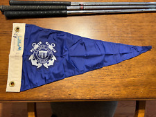 Vintage 1960s USCG U.S. COAST GUARD AUXILLIARY Pennant Flag ~ 23" x 11" ~ EUC
-
$18.95
 VINTAGE NAUTICAL CHART MAP NJ DE DELAWARE RIVER SMYRNA RIVER to WILMINGTON
-
$45.00
 Vintage Nautical Chart, C & G S #241 -Salem Marblehead and Beverly Harbors
-
$65.00
 Vintage RARE Boating Atlas of Tidewater Virginia 1962 Map Nautical Chart Coast
-
$29.99
 VINTAGE NAUTICAL CHART 4/5/1969 POINT SUR TO SAN FRANCISCO 7423g
-
$200.00
 Vintage Maritime Nautical 'Squadron' Signal Flag 3 1/2 Coast Guard
-
$45.00
 Vintage Nautical Chart, C & G S #346 -Edgartown Harbor, Marthas Vineyard
-
$175.00
 WWII 1941 Etched Glass Mobile AL Coast Gaurd Ships Porthole Window Thomas Guice
-
$34.99
 VINTAGE NAUTICAL CHART 1997 WEST QUODDY HEAD TO NEW YORK 43023e
-
$29.99
 VINTAGE 1963 NANTUCKET SOUND OSTERVILLE TO GREEN POND NAUTICAL CHART 62023j
-
$30.00
 Swivelier Industrial Marine Electrical Fixture
-
$45.00
 Vintage Nautical Chart, C & G S #347 -Vineyard Haven, Marthas Vineyard
-
$14.99
 NAUTICAL CHART 1997 NANTASKET BEACH COHASSET HARBOR 2 SIDED 5723e
-
$55.00
 20+ Vtg. Hydrographic Maritime Maps Charts Lake Huron Erie St. Clair Islands
-
$99.99
 Pennant Flag US Coast Guard Auxiliary Red Rare 24x23x11 Hortie -Van
-
$120.00
 VINTAGE NAUTICAL CHARTS - 8 TOTAL - GUADELOUPE AND MARTINIQUE - SHIPS FREE
-
$24.99
 VINTAGE 1973 PORTSMOUTH HARBOR NAUTICAL MAP 33X44 INCH #211 NOAA 51423d
-
$39.99
 VINTAGE 08 NAUTICAL CHART NAVESINK AND SHREWSBURY RIVERS & SANDY HOOK BAY 42423d
-
$39.99
 VINTAGE 1976MARTHA'S VINEYARD TO BLOCK ISLAND NAUTICAL CHART 37 X 42 INCH 71123f
-
$8.00
 U.S. Coast Guard Auxiliary Boating Skills & Seamanship 9th & 10th Editions
-
$1575.00
 antique maritime air horn


