 Antiques (US)
-
$55.00

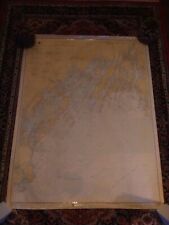
 Cruising Guide New York To Nantucket And Cape May
-
$59.00
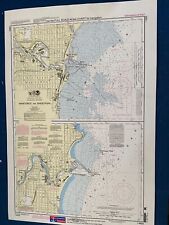
 RI Mass 1973 nautical Noaa chart narragansett bay  36 by 48 navigation map
-
$265.00
 1853 MAURY'S STORM and RAIN NAVIGATIONAL CHART ~ THE NORTH ATLANTIC ~ SERIES E
-
$32.00
 Vintage NOAA Nautical Chart 5144 Santa Monica Bay / King Harbor 24x35 in 1967
-
$25.00
 Vintage Nautical Chart 12346 Hudson River Yonkers Piermont. NOAA 1984 24.5" x48
-
$13.95
 Nautical Chart Florida 1997 St. Lucie To Ft. Myers Lake Okeechobee
-
$22.95
 Massachusetts Geodetic Survey Map USC & GS Essex County Haverhill Vintage
-
$34.99
 1955 West Indies Haiti Nautical Chart Map Ft Liberte to Ile Tortuga 465 Map
-
$34.99
 1963 Navigation Charts Mississippi River Map Book 100+ pages US Army Corp. Book
-
$25.00
 1986 Straits Of Florida & Approaches Chart Marine Soundings In Fathoms.43X36”
-
$9.90
 Vintage Vancouver Canada Washington Nautical Chart Map 1983 Haro Strait
-
$19.99
 Vintage Hydrographic Chart Hawaiian Islands to Samoa Pacific Ocean 1940s WW2
-
$34.95
 U. S. East Coast Maine "Damariscotta+" Maritime 47 X 36" Map # 13293 1989 28 Ed
-
$239.00
 1853 MAURY'S WIND and CURRENT CHART. SERIES A. SOUTH PACIFIC No. 10 ~ CHILE
-
$32.00
 Vintage NOAA Nautical Chart 5128 Two Harbors on Catalina Island 24x28 in 1967
-
$41.95
 Massachusetts Geodetic Survey Map x 2 USC & GS Essex County WPA Vintage
-
$39.97
 Map Nautical Chart Massachusetts Bay #1207 1938 U.S.C & GS 35 Vintage
-
$39.97
 Map Nautical Chart Approaches To NY Nantucket Shoals 5 Fathom Bank 1939 Vintage
-
$39.97
 Nautical Chart Long Island Sound #216 N Shore 1937- 28 3/16 x 36 5/8" Vintage
-
$13.95
 Nautical Chart Florida 1995 Palm Shores To West Palm Beach
-
$29.99
 Lot of 4 Vintage Nautical Charts Maps - Sandy Hook, Chesapeake Bay
-
$29.99
 Rare Vintage 1949 United States US Navy Military North Pacific Pilot Chart Map
-
$299.99
 Original Sea Captain's 1873 Canvas Backed Nautical Chart Great Bahama Bank
-
$10.00
 Lake Survey Charts/ Nautical New York Canals. 1956 Vintage Corps of Engineers US
-
$19.99
 Vintage Hydrographic Chart Bougainville Strait Solomon Islands 1940s WW2
-
$15.00
 Vintage 1960-1961 Lake Winnipesaukee Navigation Chart
-
$19.99
 Vintage Hydrographic Chart Apra Harbor Guam North Pacific Ocean WW2 1940s
-
$150.00
 US Dept. Of Commerce 1949 Nautical Maritime Navigational Map Maine Bar Harbor
-
$150.00
 1952 US ARMY LAKE SURVEY CHARTS OF NEW YORK CANALS Erie Canal Champlain Seneca
-
$22.00
 Pocket NOAA Nautical Chart of Manitowoc and Sheboygan #14922
-
$32.00
 Vintage NOAA Nautical Chart 5115 Santa Cruz Channel. Measures 44 x 33 inches.
-
$49.99
 Vintage Nautical Charts Maine Frenchman & Blue Hill Bays
-
$49.99
 2 Vintage Waterproof Loran-C Overprinted Course Plotter Chart Map California
-
$9.95
 Five Vintage Seamanship/Navigation Booklets
-
$25.00
 Vintage Nautical Chart 12339 East River- Tallman Island to Queensboro Bridge.
-
$15.00
 Vintage 1960’s South Florida & Miami Area Fishing Charts 6 Maps Tackle Pub.
-
$45.00
 Vintage Nautical Charts Maine Casco Bay • Large 46"x36"
-
$19.99
 Vintage Hydrographic Chart Samoa Group Upolu Mulifanua Anchorage 1943 WW2
-
$68.00
 Nautical Chart Maritime Map 1960's Vintage HO-5436 36"X46" VANCOUVER QUATSINO
-
$68.00
 Nautical Chart Maritime Map 1960's Vintage HO-2827 28X41 INCH GENN ISLANDS BC
-
$58.48
 World War II Era (May 1943) Nantucket Sound & Approaches Nautical Map 8th Ed.
-
$4.00
 Chart of the New World - 1526 - Juan Vespucci - Navigational Map - 13”x9.75”
-
$26.00
 NOAA Piney Point Lwr Cedar Point- 12286 Navigation Survey Map POTOMAC RIVER vtg
-
$20.00
 Nautical Chart Catalog 2 Pacific Coast Hawaii Guam April 1979
-
$19.99
 Vintage Hydrographic Chart Savaii Samoa Islands 1928 with WW2 Revisions
-
$19.99
 Vintage Hydrographic Chart Yap Islands West Caroline Islands 1940s WW2
-
$19.00
 NAUTICAL CHART # 2142 - ANNAPOLIS BASIN - NOVA SCOTIA CANADA
-
$20.68
 1855 M F MAURY Hydrography Map / Chart ~ HURRICANE of AUGUST SEPTEMBER 1848
-
$24.88
 1989 Upper Mississippi River Navigation Charts U.S. Army Corps of Engineers
-
$20.00
 1975 Lake George Navigational Chart Book 9 Colored Charts 11" x 14"
-
$35.00
 C&GS Coastal Map. Head Of Chesapeake Bay #12274 13th Edition 1974
-
$11.25
 West Bay to Santa Rosa Sound Florida Nautical Chart 11385 1984 Edit. 11 NOAA
-
$1850.00
 Antique 1926 Map of Nantucket by Tony Sarg
-
$34.95
 U. S. East Coast Maine "CASCO BAY" Navigational 47 X 36" Map # 13290 1990 29 Ed
-
$10.00
 Marine Chart, Laminated Michigan NW Lower Peninsula, 11x17, West Marine
-
$10.00
 Nautical Detroit River Lake St Clair, River.1963 Corps of Eng. US Survey Chart
-
$19.99
 Vintage Hydrographic Chart San Pedro Bay California 1940s
-
$900.00
 The Western Pilot for 1829, Cumings. Ohio & Mississippi Rivers Navigation MAPS
-
$19.99
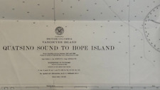 Vintage Hydrographic Chart Quatsino Sound Vancouver Island British Columbia WW2
-
$34.95
 U.S. E. Coast ME "Muscongus Bay" Maritime 47 X 36" Map # 13301 1984 17 Ed
-
$22.00
 C&GS Coastal Map - New Jersey/Delaware- Cape May To Fenwick #12244 28th Ed. 1975
-
$50.00
 US Army Engineer District Charts of the Chicago Illinois Waterway - PA13
-
$47.98
 1975 55th Ed. United States New York Jamaica Bay&Rockaway Inlet Navigation Chart
-
$19.99
 WW2 Hydrographic Chart Phoenix Islands South Pacific Ocean Vintage 1940s
-
$25.00
 NOAA Upper Green Bay Door County Nautical Sound Chart Map LORAN-C ~ 48” x 36”
-
$35.00
 1947 Tidal Current Charts Long Island Sound & Block Island Sound 6 Pgs/12 Charts
-
$19.99
 1978 Upper Mississippi River Navigation Charts Us Army Corps Of Engineer Vintage
-
$16.99
 Florida Soundings in Fathoms at mean low water Place mat Map Mercator projection
-
$19.99
 Vintage Hydrographic Chart Islands Anchorages in the Ellice Islands 1940s WW2
-
$18.00
 Vintage Anacortes, Wash., Harbor Nautical Chart USCGS 1/40000, 1938
-
$19.99
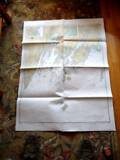
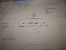 VINTAGE NAUTICAL CHART MD CHESAPEAKE BAY Cove Pt to Sandy Pt
-
$19.99
 Vintage Hydrographic Chart Corinto Harbor West Nicaragua Central America WW2
-
$24.95
 Nautical Chart Florida 1964 St. Lucie Inlet to Ft Myers + Lake Okeechobee
-
$4.00
 Chart of the Ocean Sea - 1513 - Gallipoli - Navigational Map - 13”x9.75”
-
$19.99
 Vintage Hydrographic Chart East Coast of Vancouver Island British Columbia WW2
-
$28.95
 Chart Map Nautical Navigation Cape Cod Canal Ma. 1985 Beach House Décor Vintage
-
$24.95
 Vtg Army Core of Engineers Org Chart of Personnel at Headquarters V 1959
-
$19.99
 Vintage Hydrographic Chart Point Conception to Point Sur California 1940s WW2
-
$24.00
 C&GS Coastal Map - Chesapeake Bay - Mobjack Bay To York River #494 18th Ed. 1973
-
$24.95
 Nautical Chart Florida 1964 Charlotte Harbor to Tampa Bay Florida
-
$12.34
 1993 Two-Sided Nautical Chart -- KENNEBEC RIVER, Maine - Augusta, Richmond, Bath
-
$35.00
 1945 Tidal Current Charts New York Harbor 6 Pages (Dbl Sided) 12 Charts
-
$25.00
 NOAA Nautical Chart 12364. New Haven Harbor Entrance, Port Jefferson Throgs 1987
-
$15.00
 NAVIGATIONAL CHART / MAP # 11425 - CHARLOTTE HARBOR TO TAMPA BAY
-
$59.99
 ESTATE Lot of 10 Vintage Nautical Charts, US Gulf Coast Circa 1943-1987 MS-AL-LA
-
$24.95
 US Coast and Geodetic Maritime Survey 1955 Chesapeake Bay Entrance Chart
-
$11.99
 NAUTICAL CHART MAP 18661 SACRAMENTO AND SAN JOAQUIN RIVERS IN CA.
-
$17.00
 NAUTICAL NAVIGATIONAL CHART # 11485 - TOLOMATO RIVER TO PALM SHORES - FLORIDA
-
$4.00
 Chart of the Alaska Coast - 1593 - de Corneille - Navigational Map - 13”x9.75”
-
$24.95
 US Coast and Geodetic Maritime Survey 1955 Chart Chesapeake Delaware Canal
-
$19.99
 Vintage Hydrographic Chart Los Angeles Harbor Vicinity 1940s
-
$44.99
 Rare Vintage 1945 United States US Navy Military North Atlantic Pilot Chart Map
-
$19.99
 Vintage Hydrographic Chart Phoenix Islands South Pacific Ocean 1943 WW2
-
$20.68
 Old 1855 M F MAURY Hydrography Map / Chart ~ EXAMPLE of a PILOT SHEET ~ Free S&H
-
$10.00
 Nautical Of Illinois Waterway, Army Eng. 1961 Vintage Corps of Engineers Charts
-
$29.99
 1882 Nautical Chart Map London Published Guadeloupe West Indies 885 Map 41"x28"
-
$690.00
 Georgetown Harbor SC Cape fear River NC 1887 book US Army Engineer report
-
$19.99
 Hydrographic Chart Caroline Islands Kusaie or Ualan Island N. Pacific Ocean WW2
-
$22.50
 Pocket NOAA Nautical Chart of Lake Ontario #14800
-
$68.00
 Nautical Chart Maritime Map 1960's Vintage HO-5378 28X40 INCH VANCOUVER SCOTT


