-

$29.99
 Chart Kit BBA Chesapeake & Delaware Bays Region 4
-
$95.95
 Admiralty 2490 UNITED STATES MAINE MONHEGAN ISLAND TO CAPE PORPOISE Map Chart
-
$81.00
 CHINA MSA 44126 WUSONGKOU TO LIUHEKOU GENIUS NAUTICAL MARITIME PAPER Map Chart
-
$81.00
 JAPAN COAST GUARD W166 IMARI WAN AND APPROACHES GENIUS MARITIME PAPER Map Chart
-
$9.95
 Five Vintage Seamanship/Navigation Booklets
-
$19.99
 Vintage Hydrographic Chart Savaii Samoa Islands 1928 with WW2 Revisions
-
$9.48
 1918 MAP U.S. NAVY HYDROGRAPHIC OFFICE U.S. GULF COAST No 1112 - 30"x44"
-
$15.00
 NOAA Chart Charleston Harbor And Approaches 11521
-
$89.99
 Block Island Rhode Island Wood Chart 3-D Nautical 16"x20" O9H
-
$2.99
 Canadian Nautical Chart Jan 1972; Southern British Columbia coast, Vancouver isl
-
$40.32
 NOAA Chart 11013: Straits of Florida and Approaches
-
$17.00
 NAVIGATIONAL CHART # 991 8 CHARTS IN 1 - JAPAN - VARIOUS PORTS PLANS HOKKAiDO
-
$51.99
 1897 Chart showing Light Stations in Long Island Sound - Darrow & Comstock Ad.
-
$81.00
 CHINA MSA 44126 WUSONGKOU TO LIUHEKOU NAUTICAL MARINE GENIUS PAPER Map Chart
-
$81.00
 CHINA MSA 44125 YUANYUANSHA TO WUSONGKOU MARINE GENIUS NAUTICAL PAPER Map Chart
-
$185.00
 ORIGINAL ANTIQUE MAP NAUTICAL CHART Bahama Islands Exuma Sound Eastern Approach
-
$44.99
 Rare Vintage 1945 United States US Navy Military North Atlantic Pilot Chart Map
-
$33.00
 Vintage 1929 Fenwick Island Light Chincoteague Inlet Nautical Chart Map -41”x35”
-
$12.59
 1856 Papeete Island of Tahiti Tidal Observations U.S. Coast Survey Moon Phases
-
$15.00
 WW2 Hydrographic Chart Okisollo Channel British Columbia Canada 1940s
-
$19.99
 Antique Sailing Chart Map Nautical Navigation VTG PRINT 18.5 x 13 - EUROPE 1560
-
$5.75
 Vintage Nautical Chart Map, 1964, St. Lawrence River, Lake Ontario LAKE ERIE etc
-
$45.00
 Vintage Nautical Charts Maine Casco Bay • Large 46"x36"
-
$22.95
 Massachusetts Geodetic Survey Map USC & GS Essex County Haverhill Vintage
-
$19.99
 Vintage Hydrographic Chart Yap Islands West Caroline Islands 1940s WW2
-
$18.95
 1650 Bahamas Caribbean Historic New World Map - 20x30
-
$19.99
 VTG Hydrographic Chart East Coast of Vancouver Island British Columbia 1940s WW2
-
$74.95
 Vintage Large 43" Nautical Map Long Block Island Sound Montauk New London 1941
-
$165.00
 ORIGINAL ANTIQUE MAP NAUTICAL CHART Charleston Light to Cape Kennedy Hilton Head
-
$143.45
 Admiralty 3384 Mississippi River New Orleans To Baton Rouge Vintage Map Charts
-
$24.00
 Vintage 28 x 45 Nautical Map Port of Cairns 1970s
-
$76.95
 Admiralty 2257 Golfo De Guayaquil To Bahia Buena Ventura Peru Ecuador & Colombia
-
$49.99
 2 Vintage Waterproof Loran-C Overprinted Course Plotter Chart Map California
-
$19.99
 Vintage Hydrographic Chart Samoa Group Upolu Mulifanua Anchorage 1943 WW2
-
$24.00
 Vintage Nautical Chart # 14965 Lake Superior Redridge to Saxon Harbor 1976
-
$299.99
 Original Sea Captain's 1873 Canvas Backed Nautical Chart Great Bahama Bank
-
$18.99
 1971 Nautical Charts Palm Shores to West Palm Beach to Miami 845-SC and 847-SC
-
$17.00
 Vintage Bahamas Nautical Sketch Chart Map - Rum Cay - 11x17
-
$125.00
 ORIGINAL ANTIQUE MAP NAUTICAL CHART Asia Arabia Gulf of Aden Harbor .
-
$99.00
 Framed 1968 Nantucket Island MA NOAA Chart Vintage 15”x19”
-
$24.00
 KNIGHT INLET Nautical Chart GILFORD ISLAND Map 46"x33" BRITISH COLUMBIA Canada
-
$19.99
 Vintage Hydrographic Chart Corinto Harbor West Nicaragua Central America WW2
-
$21.00
 NAVIGATIONAL CHART / MAP # 515 -MALI LOSINJ & PRIZNA TO ZADAR - YUGOSLAVIA
-
$44.44
 RICHARDSON'S Waterproof Chartbook, 2007 -- CAPE COD, Buzzards Bay, NANTUCKET
-
$20.00
 Nautical Chart Catalog 2 Pacific Coast Hawaii Guam April 1979
-
$19.99
 Vintage Hydrographic Chart Islands Anchorages in the Ellice Islands 1940s WW2
-
$18.00
 Vintage Anacortes, Wash., Harbor Nautical Chart USCGS 1/40000, 1938
-
$24.00
 C&GS Coastal Map - Chesapeake Bay - Mobjack Bay To York River #494 18th Ed. 1973
-
$2.99
 Vtg Nautical Chart: C&GS 1253 East Cape to Mormon Key
-
$18.95
 1590s Old World Map Poster - Francis Drake's Voyages around the World - 20x30
-
$75.00
 MAPTECH FLORIDA EAST COAST AND THE KEYS 14th EDITION NAV CHART
-
$27.00
 Vintage 1930 Delaware River - Philadelphia To Trenton Nautical Map - 34” x 31”
-
$25.00
 NOAA Upper Green Bay Door County Nautical Sound Chart Map LORAN-C ~ 48” x 36”
-
$33.00
 Vintage 1929 Chesapeake Bay Smith Point To Cove Point Nautical Map - 43.5” x 33”
-
$39.99
 1961 US Dept Of Commerce Nautical Vintage Map Habana To Tampa Bay 31 X 45 Cuba
-
$19.99
 Vintage Hydrographic Chart San Pedro Bay California 1940s
-
$27.00
 1865 Coast Survey Plane Table, Antique Survey Equipment, 1865
-
$24.99
 Vintage Nautica Chart 837-SC, August 1971, SC Intracoastal Waterway.
-
$12.00
 NAVIGATIONAL CHART / MAP PALM SHORES TO WEST PALM BEACH FL. # 11472
-
$17.00
 Vintage Bahamas Nautical Sketch Chart Map - Sail Rocks To Cistern Cay - 11x17
-
$24.95
 Vtg Army Core of Engineers Org Chart of Personnel at Headquarters V 1959
-
$19.00
 NAUTICAL CHART # 2142 - ANNAPOLIS BASIN - NOVA SCOTIA CANADA
-
$15.00
 Vintage 1960-1961 Lake Winnipesaukee Navigation Chart
-
$19.99
 Vintage Hydrographic Chart Nanoose Ballenas Channel British Columbia 1940s WW2
-
$30.00
 C&GS Coastal Map - Chesapeake Bay Entrance #1222, 1973, 37th Edition 35”X 45”
-
$4.00
 Chart of the Ocean Sea - 1513 - Gallipoli - Navigational Map - 13”x9.75”
-
$35.00
 1947 Tidal Current Charts Long Island Sound & Block Island Sound 6 Pgs/12 Charts
-
$27.96
 U. S. East Coast Maine "Damariscotta+" Maritime 47 X 36" Map # 13293 1989 28 Ed
-
$24.99
 Nautical Tracking Chart #5405-44M 1963 large 36" x 54"
-
$10.00
 Marine Chart, Laminated Michigan NW Lower Peninsula, 11x17, West Marine
-
$19.99
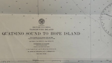 Vintage Hydrographic Chart Quatsino Sound Vancouver Island British Columbia WW2
-
$30.00
 ADC CENTRAL CHESAPEAKE BAY CHART AND FENWICK TO CHINCOTEAGUE INLET NAV CHARTS
-
$9.99
 1976 NOAA Sound Chart #11430 Florida Lostmans River To Wiggins Pass 8th Ed. (43)
-
$0.99
 Vintage Nautical Chart 14851 Michigan Lake St Clair 4th ed Aug 1975 NOAA
-
$4.00
 Chart of the New World - 1526 - Juan Vespucci - Navigational Map - 13”x9.75”
-
$900.00
 The Western Pilot for 1829, Cumings. Ohio & Mississippi Rivers Navigation MAPS
-
$150.00
 US Dept. Of Commerce 1949 Nautical Maritime Navigational Map Maine Bar Harbor
-
$17.00
 Vintage 1986 Dominican Republic Mona Passage Nautical Chart Map - 47” x 34”
-
$25.95
 1639 Chesapeake Bay to Florida Historic Vintage Style Dutch Wall Map - 24x36
-
$47.98
 1975 55th Ed. United States New York Jamaica Bay&Rockaway Inlet Navigation Chart
-
$16.00
 NAUTICAL NAVIGATIONAL CHART # 11467 WEST PALM BEACH TO MIAMI - FL
-
$29.99
 VTG Nautical Depth Chart Little Egg To Hereford Inlet 1984 U.S. East Coast NJ
-
$27.59
 1859 Coast Survey Chart St. Mary's River Cornfield Harbor Pt. Lookout Maryland
-
$17.00
 Vintage 1985 Dominican Approaches Bahia De Samana Nautical Chart Map - 47” x 34”
-
$17.00
 Vintage Bahamas Nautical Sketch Chart Map - Little San Salvador - 11x17
-
$19.00
 NAVIGATIONAL CHART / MAP # 1225 - GULF OF CAMPECHE - GULF OF MEXICO
-
$45.00
 Nautical Chart/Map of South America’s Estrecho De Magallanes to Cabo De Hornos
-
$35.00
 Nautical Chart/Map of Georgia’s St. Andrew Sound and Satilla River
-
$74.95
 Old Vintage Large 44" Nautical Map Oyster & Huntington Bay Long Island Sound
-
$17.00
 Vintage Bahamas Nautical Sketch Chart Map - Bock Cay To Channel Cay - 11x17
-
$13.95
 Peninsula of Florida 1639 Vintage Style Vinckeboons Map - 18x24
-
$19.99
 Vintage Hydrographic Chart Point Conception to Point Sur California 1940s WW2
-
$21.00
 1855 USCS Map New Jersey, Long Island, New York, Connecticut, Hudson River
-
$17.00
 NAUTICAL NAVIGATIONAL CHART # 11485 - TOLOMATO RIVER TO PALM SHORES - FLORIDA
-
$20.00
 Nautical Chart/Map of Block Island Sound’s Point Judith to Montauk Point
-
$8.00
 Vintage Texaco 1966 Cruising Nautical Chart No 3 NY Harbor to Cape Henry VA
-
$33.99
 Chart Kit BBA Region 6, Intracoastal From Norfolk to Jacksonville Nautical Maps
-
$65.00
 1852 SURVEY/RECONN MAP ~ CEDAR KEYS, FLORIDA ~ CHANNEL No. IV
-
$76.95
 Admiralty 1098 UNITED STATES LOWER MATECUMBE KEY TO BOCA GRANDE Map Chart Paper
-
$91.00
 ADMIRALTY 592 SAN FRANCISCO BAY SOUTHERN CALIFORNIA NAUTICAL GENIUS Map Chart


