 Antiques (US)
-
$85.00

 1836 State Maps (8) Engraved by George Boynton Pub. S. G. Goodrich - Book Plates
-
$49.50
 Scarce©1839 Mitchell Map New England(ME,VT,NH,MA,CT,RI) ME's Disputed Boundaries
-
$135.00
 1842 Large Map of Maine. From Morse's North American Atlas. Color
-
$299.49
 1860 U.S.C.S.Nautical Chart MONOMOY NANTUCKET SHOAL BLOCK ISLAND-1874 CORRECTION
-
$12.00
 Large 1882 Antique Map: Coast Survey of Eastern USA 1
-
$12.00
 Large 1882 Antique Map: Isogonic chart for Eastern USA, US Coast Survey
-
$27.99
 1881 Rand McNally Railroad Map Rhode Island Providence Newport Block Island RI
-
$38.00
 1589 North America Map California Nova Hispania 1872 Florida Wheeler Ortelius
-
$20.84
 Vintage 1896 INDIAN NATIONS Map 14"x11" Old Antique Original TRIBES
-
$87.49
 1891 Massachusetts Topographical Map of Counties Bordering NH, near the Ocean
-
$38.88
 1880 United States Map Barley Farming Agriculture Wisconsin California Oregon
-
$19.99
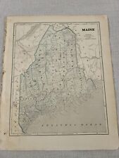
 1883 Antique Map / STATE OF MAINE / 14.5x20.5 inches
-
$21.56
 Vintage 1892 INDIAN NATIONS Map 14"x11" ~ Old Antique Original TRIBES
-
$175.00
 1870 Antique Map ~ CONNECTICUT - WEST HARTFORD
-
$45.00
 1876 maps Canton, Massachusetts, from Norfolk County Atlas, with family names!
-
$45.00
 1876 map town of Weymouth, North Weymouth, Franklin village, w/family names
-
$21.56
 Vintage 1894 INDIAN NATIONS Map 14"x11" ~ Old Antique Original TRIBES
-
$104.99
 1891 Massachusetts Topographical Map of Counties on Cape Cod, North of Nantucket
-
$38.00
 1897 MASSACHUSETTS Map East Bristol ORIGINAL Boston Lynn Worcester Gloucester
-
$20.68
 Old 1882 (Lg 15" x 21") Rand McNally Atlas Map ~ STATE of VERMONT ~ Nice Colors
-
$500.00
 1845 North America map by A.K. Johnston 25.8" x 21.2" Antique Republic of Texas
-
$27.99
 1830 Nathan Hale Map Rhode Island Providence Newport Greenwich Watch Hill Canal
-
$87.49
 1891 Massachusetts Topographical Map Counties North of Rhode Island & CT
-
$52.00
 1830 Nathan Hale Map Connecticut Hartford New Haven London Norwalk Greenwich CT
-
$20.68
 1884 County & Township Map ~ CONNECTICUT - HARTFORD ~ Old & Original ~ Free S&H
-
$15.99
 1885 McNally Map - Nova Scotia New Brunswick Halifax Frederickton Fundy - Canada
-
$24.99
 1880 Antique Atlas Map / NEW ENGLAND
-
$87.49
 1891 Massachusetts Topographical Map of Counties East of New York State
-
$45.00
 1876 map Medfield village, West Quincy, Jerusalem Rd, Franklin, MA, w/fam names
-
$44.00
 1876 map East Weymouth, Foxborough, North Weymouth, Lovells Cor. w/family names
-
$240.00
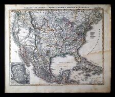 1848 Stieler Stulpnagel Map United States Mexico Texas Missouri Oregon Territory
-
$39.95
 1844 Mitchell Map:New England-Eastern States-Boston-Hartford-Nova Scotia-Ships
-
$19.99
 1883 Antique Map / STATE OF RHODE ISLAND / 10.5x14.5 inches
-
$39.99
 1855 Johnston Military Map War of 1812 United States Canada Great Lakes Niagara
-
$24.99
 1883 Antique Atlas Map / RHODE ISLAND
-
$22.00
 Dominion of Canada & Northern USA - Original 1883 Map by J. Bartholomew. Antique
-
$15.00
 Antique 1889 Map CT MA MA NH RI by George F Cram Unrivaled Family Atlas 13x10
-
$87.49
 1891 Massachusetts Topographical Map, Holland, Warren, Chicopee, Long Meadow Co.
-
$19.00
 Original 1860 S. Augustus Mitchell map of canada east hand colored!
-
$260.00
 1847 Stieler Map United States Texas Missouri Oregon Territory Mexico Canada
-
$87.49
 1891 Massachusetts Atlas Map / CITY OF LOWELL, MA
-
$11.99
 1895 Rand McNally Map - Maine - Augusta Bangor Portland Moosehead Lake Caribou
-
$45.00
 1878 United States map 22.8" x 15.1" nice color - Island of New Foundland inset
-
$21.51
 1890 Map NEW ENGLAND - MAINE, NEWHAMPSHIRE, VERMONT, MASSACHUSETTS -(10x12)#P290
-
$29.99
 1852 Antique Atlas Map / NEW ENGLAND, or, EASTERN STATES
-
$19.99
 1885 Cortambert Map - Eastern United States New York Florida Carolina Virginia
-
$20.68
 Old 1882 (Lg 15" x 21") Rand McNally Atlas Map ~ STATE of MASSACHUSETTS, BOSTON
-
$104.99
 1891 Massachusetts Topographical Map of Northeast Tip of State
-
$104.99
 1891 Massachusetts Topo Map North of Vinyard & Nantucket Sounds,Part of Cape Cod
-
$20.68
 Vintage 1883 Atlas Map ~ NEW HAMPSHIRE ~ Old & Authentic ~ Free S&H
-
$87.49
 1891 Massachusetts Atlas Map / CITY OF NEW BEDFORD, MA
-
$100.00
 1847 Williams Map New England Massachusetts Connecticut Rhode Island Boston RR
-
$87.49
 1891 Massachusetts Atlas Map / CITY OF BROCKTON, MA
-
$87.49
 1891 Massachusetts Map / Boston Metro, Cambridge, Belmont, Watertown, Waltham
-
$24.99
 1885 Map VERMONT, NEW HAMPSHIRE, MASSACHUSETTS, CONNECTICUT, RHODE ISLAND, MAINE
-
$24.99
 1885 Antique Atlas Map / MAINE
-
$15.99
 Original Antique 1870 Map WEST FITCHBURG Rockville + MA Massachusetts BEERS
-
$120.00
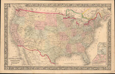
 1830 Nathan Hale Map - United States - 24 States - West Territories Texas Boston
-
$38.88
 1880 UNITED STATES Map ORIGINAL Farming Oats Agricultural Texas Colorado Florida
-
$20.68
 Rare Vintage 1911 Atlas Map ~ MAINE - AUGUSTA ~ Old & Authentic ~ Free S&H
-
$20.68
 Rare Vintage 1883 Atlas Map ~ NEW HAMPSHIRE - VERMONT ~ Old Authentic ~ Free S&H
-
$87.49
 1891 Massachusetts Atlas Map / CITY OF QUINCY, MA
-
$87.49
 1891 Massachusetts Topographical Map of Counties Northeast of Rhode Island
-
$87.49
 1891 Massachusetts Topographical Map of Counties Southeast of Connecticut River
-
$16.00
 1885 McNally Map Connecticut Rhode Island New Haven Hartford Providence Newport
-
$35.00
 1856 Black's North America - Map 17.3" x 12.5" - Antique
-
$49.99
 1846 RARE ORIGINAL MAP CANADA GREENLAND ONTARIO QUEBEC NOUVELLE GALLE MAINE USA
-
$45.95
 Old 1870 Plat Map ~ WEST FITCHBURG, WORCESTER Co., MASSACHUSETTS
-
$18.00
 1887 Cowperthwait Map - Connecticut Hartford New Haven Bridgeport Mystic Danbury
-
$87.49
 1891 Massachusetts Atlas Map / CITY OF LYNN, MA
-
$15.99
 1857 Morse Map - Connecticut Rhode Island Long New York Haven Newport Providence
-
$29.99
 1875 Antique COLOR Gray’s Atlas Map / NEW ENGLAND
-
$87.49
 1891 Massachusetts Atlas Map / CITY OF HOLYOKE, MA
-
$87.49
 1891 Massachusetts Atlas Map / CITY OF WOBURN, MA
-
$500.00
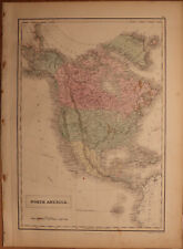
 1840 North America antique map by Greenleaf - 14.2" x 12" scarce 1st edition
-
$18.00
 1879 Petermann Map - NE United States New England York Long Island Boston Jersey
-
$87.49
 1891 Massachusetts Atlas Map / CITY OF SPRINGFIELD, MA
-
$87.49
 1891 Massachusetts Atlas Map / CITY OF LAWRENCE, MASSACHUSETTS
-
$87.49
 1891 Massachusetts Atlas Map / CITY OF SALEM, MA
-
$39.99
 1830 Nathan Hale Map - New Hampshire Portsmouth Concord Amherst Charleston Keene
-
$60.00
 1886 Tunison Map United States Indian Territory Oklahoma Dakota Texas California
-
$27.99
 c 1889 Cowperthwait Map - United States - Indian Territory & Oklahoma Lands Rush
-
$87.49
 1891 Massachusetts Atlas Map / CITY OF FALL RIVER, MA
-
$59.50
 1864 Map State of New York County Map Antique Original Hand Colored Mitchell
-
$20.68
 Old 1873 Johnson's Atlas Map ~ NEW HAMPSHIRE - VERMONT ~ Free S&H
-
$27.99
 1830 Nathan Hale Map New Hampshire Concord Portsmouth Dartmouth White Mountains
-
$49.99
 1871 Antique Map / BERKSHIRE COUNTY Massachusetts
-
$31.99
 1881 US Coast Survey Map - New England Tirangulation Massachusetts Hudson River
-
$140.00
 1809 Delalain Map North America United States Louisiana California Napoleon Era
-
$27.99
 1858 Delamarche Map North America United States Canada Mexico Alaska West Indies
-
$39.99
 1830 Nathan Hale Map - Massachusetts - Boston Plymouth Cape Cod Salem Worcester
-
$27.99
 1830 Nathan Hale Map Vermont Burlington Montpelier Bennington Craftsbury Windsor
-
$18.00
 1887 Cowperthwait Map - Maine - Augusta Portland Bangor Ellsworth Rockland Bath
-
$45.00
 1844 U.S.A. Map by Olney "NEW ENGLAND and NEW YORK" States (VT NH ME MA CT RI)
-
$19.99
 1886 Banker Attorney Map by Cram - Connecticut Hartford New Haven Bridgeport CT
-
$75.00
 1860 United States & Territories by Mitchell beautiful antique map 22.7" x 14.7"
-
$30.00
 1876 United States Agriculture & Vitality map antique ~ 17.3" x 13.8" hand color
-
$19.99
 1885 McNally Map Maryland Baltimore Washington DC Hagerstown Chesapeake Bay MD
-
$200.00
 1843 Stulpnagel Map North South America United States Texas California Brazil SA
-
$35.95
 Scarce 1835 Smith Map: Eastern States ME,VT,NH,MA,CT,RI: Counties, Canals, Ships


