 Antiques (US)
-
$13.95

 1892 Indian Territory Historic Vintage Style Oklahoma Wall Map - 18x24
-
$624.50
 EXTREMELY RARE Antique Portsmouth NH Map 1850 HF Walling Brewster Publisher
-
$125.00
 Original J.H Colton of NORTH AMERICA IN 1855 Map - Heritage Maps Number 10
-
$62.99
 1839 Michigan J.H. Young engraved 17x22 Map vtg Antique United States Repro 1957
-
$6250.00
 Geological Profile Extending from the Atlantic to Lake Erie by Amos Eaton, 1823
-
$40.00
 1894 Oklahoma & Indian Territory Map On Wood for Wall Hanging
-
$25.95
 1862 Bacons Military Map of America Civil War Wall Map Poster - 24x36
-
$13.95
 Florida 1823 Historic Decorative Wall Map - 16x20
-
$23.95
 1840s “United States of Mexico” Vintage Style Southest Wall Map - 24x30
-
$71.00
 1860 Hunterdon County New Jersey Wall Map w/ Homeowner Names and Plots Outlined
-
$16.95
 1835 Texas, Indian Territory & Mexican States Map Wall Map - 20x24
-
$599.00
 Original 1833 Mitchell's Hand Colored Reference & Distance U.S. Wall Map 54 x 70
-
$273.00
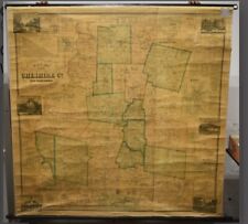
 Rare Antique Map 1859 Penobscot County Maine Wall Map showing residences 60x62
-
$650.00
 1844 Hanging Wall Map MITCHELL'S NATIONAL MAP of the AMERICAN REPUBLIC
-
$99.95
 Beautiful Original 1899 New York City Map/ GREAT WALL ART
-
$125.00
 Original Antique 1869 Map of the of Mystic CT Historical Maritime town Wall Map
-
$23.95
1830s Texas & Indian Territory Land Grants Historic Wall Map - 24x30
-
$10.00
 MAP 1845 The 28 United States Territory w Annexation of TX 63"X44"
-
$2999.99
 Rare 1859 Pre Civil War National Large Hand Colored Wall Map Of The U.S. Phelps
-
$1299.00
 Real Deal! Antique Dated 1855 LARGE Wall Hanging Map of the USA J. H. Colton
-
$51.00
 1887 County and Township Map of Utah and Nevada
-
$34.95
 Pasadena 1888 Sanborn Map, Exquisitely Detailed Map - Poster
-
$55.00
 Massachusetts Railroads & Townships Boston Cape Cod 1871 Walling & Gray map
-
$35.99
 ANTIQUE 1869 HAMDEN NEW YORK HAND COLORED ENGRAVING MAP ON ARCHIVAL FABRIC 12X15
-
$89.95
 Alabama & Georgia Indian Territory Map 1823 AL & GA RP 24x30" FREE SHIPPING!
-
$23.95
 1863 Ohio Township and County Historic Vintage Style Wall Map - 24x28
-
$24.99
 Canvas Color Reproduction 1851 New Map Of The Gold Region In California-C Gibbes
-
$895.00
 Antique c1870 Watchung Heights NEW JERSEY Birds Eye View Construction BROADSIDE
-
$95.00
 Province of Ontario Canada Toronto St. Lawrence 1875 Walling & Tackabury map
-
$200.00
 Antique Augustus Mitchell 1867 Original Hand Colored Map Alaska 13 x 15 RARE
-
$165.00
 New York City in 1695 Lower Manhattan Wall Street Broad Way 1851 historical map
-
$75.00
 New Brunswick Canadian Maritimes New Castle 1875 Walling detailed map
-
$89.00
 Rare Vintage 1883 Farm & Township Map Sadsbury, Chester County, Pennsylvania
-
$1279.00
 1856 YORK County MAINE Wall Map w/ 20 Inset Maps! Navy Yard, Kennebunkport
-
$100.00
 1888 Map of San Jose, California (1972 Reprint)
-
$89.95
 Russell Lee County Alabama Indian Territory Map 1832 RP 24x30" FREE SHIPPING!
-
$1100.00
 BEAUTIFUL 1843 Hanging Wall Map MITCHELL'S NATIONAL MAP of the AMERICAN REPUBLIC
-
$425.00
 Antique 1856 Fagan 'Map of Schenectady County NEW YORK' WALL MAP -Albany Suburbs
-
$395.00
 Canada Quebec Lake St. Jean c.1889 huge linen backed folding wall map
-
$68.00
 Framed 1868 Outline Map of Montgomery Co.,NY Published by Stranahan & Nichols
-
$95.00
 Glen Cove LI NY -VINTAGE 1870s MAP OF VILLAGE- Matted & Framed
-
$2500.00
 Large 41" X53" Colton's Sectional Wall Map Of The United States Of America 1881
-
$599.00
 Real Deal! Antique 1858 Wall Hanging Canvas Map Cheshire County NH Smith Morely
-
$21.95
 COPY 1863 Lloyds Military Map Border & Southern States territory held by Rebels
-
$89.95
 Chambers County Alabama Indian Territory Map 1832 RP 24x30" FREE SHIPPING!
-
$1295.00
 Antique 1856 York County Maine J.L. Smith & Co Scroll Map 60X60 Inches RARE HTF
-
$1800.00
 Original Large Phelps & Ensign's Coast To Coast Hand Colored Wall Map 1841: RARE
-
$16.20
 U.S. Coast Survey 1865 North Carolina W.P. Cumming Map Print
-
$125.00
 Vintage Antique 1895 San Francisco CA Wall Map Excellent Framing Size 11x14
-
$300.00
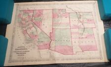 1867 Johnson's California, with Utah, Nevada, Colorado, New Mexico and Arizona
-
$23.95
 1814 State of Louisiana Historic Vintage Style Wall Map - 24x28
-
$1799.95
 Large 1883 MAP OF ANSONIA, BIMINGHAM, DERBY, SHELTON, WEST ANSONIA CT
-
$159.95
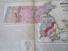
 Framed Original 1887 Antique Map of Massachusetts
-
$3000.00
 Colton's Map of the United States of American, The British Provinces 1855
-
$2500.00
 J.H.Young MITCHELL’S NATIONAL MAP OF THE AMERICAN REPUBLIC 1843 VeryGood 36x45
-
$87.50
 Painted Post Greenwood Original 1873 New York Map From Steuben County Atlas
-
$5500.00
 Original HUGE (4' X 6'!) S. Augustus Mitchell's Hand Colored U.S. Wall Map 1833
-
$1250.00
 Samuel Augustus Mitchell NATIONAL MAP OF THE AMERICAN REPUB 1846 Very Good 48x39
-
$100.00
 John Gillette 1856 map of Dutchess County, NY (Original) REDUCED AGAIN!
-
$23.95
1820s “United States of Mexico” Vintage Style Southest Wall Map - 24x30
-
$21.95
 Vtg 1966 Post Route 1896 South North Carolina Topographical WP Cumming Map Print
-
$19.99
 Bird's Eye View 1868 Grand Rapids MI Vintage-Style City Map 18.5” x 28”
-
$249.99
 ANTIQUE WALL MAP GILLETTES MAP OF MONROE COUNTY NY 1858
-
$595.00
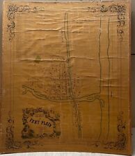 Antique 1852 'Map of FORT PLAIN Montgomery County NEW YORK' Town Cadastral Map
-
$26.00
 Talbot County Realtors map 1875 printed as 17" X 22"
-
$175.00
 1856 Map Of Kentucky
-
$875.00
 SCARCE Antique 1888 'Map of the Town of ANDOVER Massachusetts' Wall Map
-
$95.00
 Antique 1892 North Pole Unknown Region Map Excellent Large Wall Size 15 1/2 x 22
-
$3000.00
 Antique Original 1860 Farm Line Map of Alexandria Township Hunterdon County
-
$150.00
 Henry F. Walling 1855 Map of The State of Rhode Island Plantations
-
$65.00
 Massachusetts Geological Map Rock Formations 1871 Walling & Gray map
-
$200.00
 1867 Kansas Colorado Montana & Dacota Hand Colored Map 13 x 15 Mitchell Antique
-
$79.00
 Antique Map Washington Territory Milk & Columbia River Montana WA 1860 LARGE
-
$350.00
 1864 Johnson's California with territories of Utah, Nevada, Colorado, New Mexico
-
$2000.00
 D. McCarthy MAP OF THE BOROUGHS OF DANBURY AND BETHELL CONN 1854 Very Good 45x36
-
$3500.00
 Herbert Shedd PLAN OF CHESTNUT HILL IN BROOKLINE AND NEWTON 1856 Very Good 28x30
-
$89.95
 Barbour County Alabama Indian Territory Map 1832 RP 24x30" FREE SHIPPING!
-
$120.00
 Greenfield Mass 1895 wall map ORIGINAL- top roller only Massachusetts - eb-408
-
$650.00
 Walker Lithograph CO MAP OF THE TOWN OF WINCHENDON, MASS 1890 Very Good 30x27
-
$1489.51
 Antique Chicago Illinois Maps Hyde Park Original 1876 23x25 Inches Dealer Lot
-
$1500.00
 Large 38 X62 Stanford's Sectional Wall Map Of The United States Of America 1875
-
$5280.00
 1857 Pictorial Map of The United States, Ensign, Bridgman & Fanning
-
$347.00
 1852 Antique Wall Map Monroe County New York with Original Rollers. Linen Backed
-
$25.00
 Easton, Md. 1877 Town Map POSTER 17"X22" Talbot County COPY from RARE original
-
$49.95
 Beautiful Original 1899 Iowa Large Color Map/10x14/ GREAT WALL ART
-
$80.00
 Map & Bank Calendar, Comstock Lode, 1920s, Silver Mining, Nevada,
-
$165.00
 1898-99 USGS 20th AR Forest Reserves Atlas 8 Color Maps Huge Washington Wall Map
-
$19.00
 MAP 1845 The 28 United States w Annexation of TX Old History NEW 17"x11" School
-
$5500.00
 Original Large 54" X 69" S. Augustus Mitchell's Hand Colored U.S. Wall Map 1834
-
$995.00
 Gallery Quality San Juan Islands first topographical map, 1841 Wilkes expedition
-
$600.00
 Sanford And Everts MAP OF THE VILLAGE OF KEENE, NEW HAMPSHIRE 1873 Fair 54x42
-
$125.00
 1878 California and Nevada Map w/ Multiple Insets
-
$26.00
 1876 Map of Town of Rockland Lake , Knickerbocker Ice Co,Houses and Ice Train
-
$49.95
 Beautiful Original 1899 Ohio Large Color Map/11x14/ GREAT WALL ART
-
$950.00
 E.M. Woodford MAP OF WINDHAM COUNTY, CONNECTICUT 1856 Very Good 59x46
-
$6500.00
 CRIPPLE CREEK & VICTOR COLORADO ORIGINAL Bird's-eye-view gold mining MAP 1896
-
$1000.00
 H.F. Walling Map of the City of Boston and its Environs 1866 Very Good 62x61
-
$1750.00
 Samuel Augustus Mitchell NATIONAL MAP EXHIBITING UNITED STATES 1858 Good 64x64
-
$350.00
 Map UNITED COUNTIES LEEDS & GRENVILLE by Walling 1861 Rare Canada Map 5ft x 5ft
-
$110.00
 Partial Vintage Wall Map Of Philadelphia area 1860's Civil War Era S.N. Beers


