 Antiques (US)
-
$30.00

 Stanley in Africa 1885 CONGO NATIVES EQUATOR STATION Matted Harper's Print
-
$8.77
 Projected Railways across West Africa 1885 old antique vintage map plan chart
-
$7.52
 Hydrography of Africa according to Mediaeval Geographers. Sketch map 1885
-
$8.77
 Chief Routes of Explorers in the Interior of Africa (1883). Sketch map 1885
-
$20.07
 Ancient Kingdom of Kongo. Congo. Africa. Angola 1885 old antique map chart
-
$17.56
 Ancient Mauritania, per Bourguignat. Shows Atlantis North Africa 1885 old map
-
$8.77
 Routes of explorers who have crossed the continent. Africa. Angola 1885 map
-
$7.52
 Range of Mohammedanism/Islam in Central/West Africa. The Niger Basin 1885 map
-
$8.77
 Tuaregs on a Journey. Africa. The Sahara 1885 old antique print picture
-
$15.05
 Religions of Africa. Sketch map 1885 old antique vintage plan chart
-
$6.26
 Primeval forest at Fazogl. Africa 1885 old antique vintage print picture
-
$8.77
 Languages of Africa. Sketch map 1885 old antique vintage plan chart
-
$11.28
 Distribution of the Rainfall in Africa. Sketch map 1885 old antique chart
-
$8.77
 Routes of the chief explorers in the Western Sahara. Africa 1885 old map
-
$6.26
 Kadi of Khartoum and Hadendoa Sheikh. Africa 1885 old antique print picture
-
$11.28
 Isothermal Lines of Africa. Sketch map 1885 old antique vintage plan chart
-
$11.28
 Lines of equal cloudiness in Africa 1885 old antique vintage map plan chart
-
$11.28
 Africa, according to Homann, in 1711. Congo Basin 1885 old antique map chart
-
$6.26
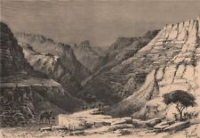 The Egueri Gorge. Africa. The Sahara 1885 old antique vintage print picture
-
$8.77
 Vegetable Zones of Africa. Sketch map 1885 old antique vintage plan chart
-
$22.57
 Depths of the South African Atlantic 1885 old antique vintage map plan chart
-
$11.28
 Highlands and Plateaux of Central & East Africa. Sketch map 1885 old
-
$8.77
 Chief routes of explorers in the upper Congo Basin. Africa 1885 old map
-
$13.79
 Inland Scenery, Slave Coast. Africa. Nigeria 1885 old antique print picture
-
$11.28
 The races of West Africa. The Niger Basin 1885 old antique map plan chart
-
$15.05
 Chief routes of explorers in the Niger Basin West of the Benue.Africa 1885 map
-
$15.05
 Rennal Mungo Park Reichardt Hypotheses on the Niger river's course 1885 map
-
$6.26
 Fulah Type. Africa. North Senegambia 1885 old antique vintage print picture
-
$12.54
 North East Africa 1885 old antique vintage map plan chart
-
$6.26
 Banks of the Nile - The Shaduf/Shadoof. Egypt. Africa 1885 old antique print
-
$12.54
 NORTH AFRICA. A Bedouin c1885 old antique vintage print picture
-
$15.05
 Sources of the Nile. Nyanza Plateau. Lake Victoria. East Africa. Sketch map 1885
-
$21.32
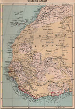 Western Sahara. Africa 1885 old antique vintage map plan chart
-
$26.34
 Eastern Sahara. Africa. Libya Niger Algeria Chad Nigeria 1885 old antique map
-
$16.30
 African explorations since 1875. Congo Basin 1885 old antique map plan chart
-
$18.81
 Distribution of the Fulahs in West Africa. North Senegambia 1885 old map
-
$17.56
 Basin of the Nile Affluents. East Africa. Lake Victoria. Sketch map 1885
-
$13.79
 Fillani Fulah Fula Fulani people. Africa. The Niger Basin 1885 old print
-
$17.56
 Outflow of Lake Victoria, according to Speke. East Africa. Sketch map 1885
-
$17.56
 Lake Tanganyika, according to Livingstone & others. Africa 1885 old map
-
$17.56
 Inhabitants of the Slave Coast. Africa. Upper Guinea 1885 old antique map


