Antiques (US)
Antiques (US)
Antiquitäten (DE)
Antiquariato (IT)
Antiques (UK)
Antiquités (FR)
Antiques (CA)
Antiques (AU)
Antiques (US)
/
Maps, Atlases & Globes
/
Europe Maps
/
1950-1959 Date Range, Down County Europe Maps
NOTE: When you buy through our links, we may earn a commission.
Learn more*
Best Match
Newest
Ending
Lowest Price
Highest Price
Best Match
Newest
Ending
Lowest Price
Highest Price
S
M
L
XL
Share
Share
Twitter
Facebook
Email
Share
Pinterest
Facebook
Twitter
Email
$12.48
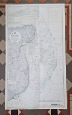
Vintage Admiralty Nautical Sea Chart The Downs South East No. L(D5) 1828 (1958)
Share
Pinterest
Facebook
Twitter
Email
$8.73
Oliver's Tourist Road Guide and map 1959 Bristol (6d)
Share
Pinterest
Facebook
Twitter
Email
$6.18
GEOGRAPHIA RAMBLERS MAP. NORTH DOWNS & THAMES SIDE. S W SECTION. circa 1950s
Share
Pinterest
Facebook
Twitter
Email
$8.25
Oliver's Tourist Road Guide and map 1959 Durdham Downs
MORE
Country/Region
England (1)
County
Down
Date Range
1950-1959
Format
Sheet Map (1)
Original/Reproduction
Vintage Original (1)
Type
Nautical Map (1)
 Antiques (US)