 Antiques (US)
-
$75.99

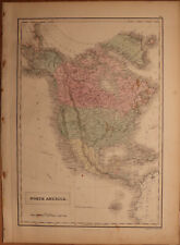
 1873 Mitchell's Map Of North America Political Divisions Authentic Hand-colored
-
$49.99
 Lot 2 Antique Maps Arizona Gaskell's Atlas of the World 1893 ca 1900 Color
-
$140.00
 Civil War Map Utah Military Department Colorado Nevada California Salt Lake City
-
$32.00
 1879 Map West Pacific NW & Southwest Group Victorian Geography 1st Edition DWAA9
-
$48.00
 1589 North America Map California Nova Hispania 1872 Florida Wheeler Ortelius
-
$48.88
 1880 United States Map Barley Farming Agriculture Wisconsin California Oregon
-
$67.00
 1891 Mexico Map ORIGINAL West Indies Texas Cuba Central America Baja California
-
$48.88
 1880 UNITED STATES Map ORIGINAL Farming Oats Agricultural Texas Colorado Florida
-
$47.88
 1856 CALIFORNIA SAN JOAQUIN VALLEY LITHOGRAPH ORIGINAL VIEW KING'S RIVER PLAIN
-
$58.00
 1896 SACRAMENTO Map Capitol Park ORIGINAL Richmond Grove Midtown Downtown
-
$57.88
 VINTAGE 1956 Mexico Map ORIGINAL Central America Baja RAILROADS United States
-
$45.00
 1878 United States map 22.8" x 15.1" nice color - Island of New Foundland inset
-
$35.00
 1856 Black's North America - Map 17.3" x 12.5" - Antique
-
$49.99
 Lot 2 Antique Maps Arizona New Mexico Gaskell's Atlas of the World Century 1897
-
$24.00
 United States - Original Map c1906 by G Philip & Son. Antique
-
$13.86
 1885 Antique Color Map of CA NV UT AZ NM CO small insert of San Francisco
-
$53.00
 1934 COLORADO Map County Township Railroads Denver Aspen Arvada Brighton Creede
-
$120.00
 1892 Death Valley Expedition Map, Biological Survey, Tulare Lake, Las Vegas, etc
-
$48.88
 1900 United States Map ORIGINAL Oat Farming Production Agriculture Texas Iowa
-
$9.99
 1944 Geographical Map Arizona Phoenix Tuscon Flagstaff Prescott Boulder Dam
-
$17.00
 Western USA - Original 1928 German Map by Meyers. Vintage
-
$15.99
 1902 Century Map - North America United States Canada Mexico Cuba Alaska Iceland
-
$75.00
 1860 US Canada Mexico C. America Mitchell antique map 15.3" x 12.5" hand color
-
$15.99
 Donner Pass California Map Truckee Cassette TripTape Tourist Natives Guide NEW
-
$19.99
 1940 Artesia Dexter New Mexico Map Water Table Depths Wells Pecos River Basin
-
$9.99
 1942 Pecos River Basin Texas New Mexico - Percipitation Distribution Map Roswell
-
$10.00
 1917 McNally Map - North America - United States Canada Mexico Alaska Cuba
-
$31.99
 1913 USGS Map San Francisco California - Haywards Quadrangle San Lorenzo Leandro
-
$19.95
 CENTURY ATLAS MAP PLATE #5 UNITED STATES OF AMERICA USA 1911 ANTIQUE ORIGINAL
-
$40.00
 Authentic 1900 Large, Detailed Color Map ~ US America Western State West ~ Rare
-
$500.00
 1845 North America map by A.K. Johnston 25.8" x 21.2" Antique Republic of Texas
-
$100.00
 Vintage Kistler Topographic Map US 1968
-
$5500.00
 1891 Extremely Rare Birdseye Map of Auburn CA, California - Real Estate & Miners
-
$80.75
 1908 Rand-McNally Vest Pocket Map of the state of New Mexico w/ Sleeve
-
$11.00
 1897 (98) N. Dakota & S, Dakota by The Century Co, 2 maps
-
$28.00
 1898 ORIGINAL MAP UNITED STATES TEXAS NEW YORK CALIFORNIA FLORIDA UTAH OHIO CUBA
-
$47.49
 1856 TEXAS CALIFORNIA ANTIQUE MAP UNITED STATES CANADA NEW YORK WASHINGTON
-
$47.49
 1848 ORIGINAL MAP UNITED STATES TEXAS FLORIDA CANADA CUBA MEXICO HAWAII NEW YORK
-
$7.50
 1948(1962) Leach Lake, California AMS Topographic Map
-
$500.00
 1853 Large Railroad Map Rio Grande to the Pacific Ocean proposed route by usprr
-
$29.99
 NATURAL ADVANCE GEOGRAPHY REDWAY AND HINMAN 1901 ATLAS MAP UNITED STATES WORLD


