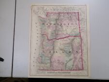
 Antiques (US)
-
$44.00

 Antique Mt. Rainer National Park 1938 USGS topographic map, text on back 26"x22"
-
$39.56
 Vintage 1892 TACOMA WASHINGTON Map 11"x14" ~ Old Antique Original UNION DEPOT
-
$74.99
 Lot 7 antique U. S. State maps Wyoming Idaho Washington Nebraska Railroads B24
-
$39.56
 Vintage 1901 SEATTLE WASHINGTON Map 11"x14" Old Antique Original PIONEER SQUARE
-
$19.99
 1894 COLOR MAP OF STRAIT OF JUAN DE FUCA SHOWING LOCATION OF WRECKS 11 x 22.50!
-
$19.99
 1894 MAP OF THE REGION OF HOODS CANAL AND NORTH BAY WASHINGTON COLOR MAP!
-
$36.00
 Large Original 1898 Antique Map WASHINGTON STATE Spokane Valley Tacoma Kennewick
-
$19.99
 1894 ENTRANCE TO QUILLAYUTE RIVER WASHINGTON W/VICINITY MAP COLOR MAP!
-
$20.68
 Old 1901 Cram's Atlas Railroad & Street Map ~ TACOMA, WASHINGTON - WRIGHT PARK
-
$39.56
 Vintage 1885 WASHINGTON TERRITORY Map 13"x11" ~ Old Antique Original OLYMPIA WA
-
$9.99
 1916 BAKERS BAY WASHINGTON PRELIMINARY EXAMINATION ENGINEERING MAP!
-
$35.50
 1891 OREGON MAP WASHINGTON ANTIQUE FULL COLOR RAILROADS MOUNTAINS VICTORIAN ERA
-
$19.00
 1897,Seattle,Washington,USGS Map,Seattle Quadrangle, topography, land class., +
-
$35.96
 Vintage 1900 WASHINGTON Map 14"x11" ~ Old Antique Original SEATTLE VANCOUVER WA
-
$14.00
 WASHINGTON 1894 Original plan map United States
-
$43.16
 Vintage 1892 TACOMA WASHINGTON Map 11"x14" ~ Old Antique Original SALMON BEACH
-
$25.16
 Vintage 1899 WASHINGTON Map 14"x11" ~ Old Antique Original DAYTON WALLA WALLA
-
$38.00
 1589 North America Map California Nova Hispania 1872 Florida Wheeler Ortelius
-
$24.99
 1875 Antique COLOR Gray’s Atlas Map / OREGON and WASHINGTON
-
$45.95
 1911 Plat Map ~ APPLE VALLEY ORCHARDS Twps., LINCOLN Co., WASHINGTON STATE
-
$17.95
 1947 Antique WASHINGTON Map of Washington State Map Gallery Wall Decor 1276
-
$48.00
 1861 Fort Washington Maryland Potomac River ENGRAVED PRINT Mount Vernon ORIGINAL
-
$34.00
 1904 CANADA Map ORIGINAL Quebec Montreal Hudson Bay British Columbia Great Lakes
-
$48.88
 1861 Civil War Engraving Georgetown Washington Heights New York Regiment Camp
-
$70.39
 Antique Civil War Map Washington Alexandria Army of Virginia 1862 Campaigns 1866
-
$45.95
 1911 Plat Map ~ Twp., 24N-31E - LINCOLN Co., WASHINGTON - COMMONWEALTH REALTY Co
-
$38.88
 1855 Washington State Sauk River Lithograph US Pacific RR Survey ORIGINAL RARE
-
$39.99
 1913 GRAYS HARBOR WASHINGTON ENGINEERING MAPS 10 MAPS 9 x 9.50!
-
$250.00
 Antique WASHINGTON DC Northwest U Street MAP Real Estate Atlas Florida Ave 16th
-
$38.00
 1930s Antique Washington State Map Animated Picture Map of Washington BLU 546
-
$82.42
 WASHINGTON State Map Rand McNally 1901 Railroad RR Business City Large Folio
-
$46.76
 Vintage 1885 WASHINGTON TERRITORY Map 13"x11" ~ Old Antique Original SEATTLE WA
-
$129.99
 Original 1872 Map OREGON & WASHINGTON TERRITORY Wagon Trails Indians Forts Mines
-
$29.00
 Antique Map Washington DC Virginia Maryland Delaware W Virginia Potomac 2 sided
-
$18.00
 Washington - Original 1911 Dated Map by Dodd Mead & Company. Antique
-
$39.99
 Original 1884 Map WASHINGTON TERRITORY Moses Reservation Olympia Spokane Seattle
-
$50.00
 Fold Out Map of Life Zones of Mount Rainer National Park 1915 by Walter P Taylor
-
$45.95
 1911 Plat Map Twp. 22N-35E - LINCOLN Co. WASHINGTON - DOWNS - GREAT NORTHERN RR
-
$48.88
 1916 UNITED STATES Map ORIGINAL LARGE Wisconsin Indiana Pennsylvania Delaware
-
$35.24
 Vintage 1900 WASHINGTON Map 14"x11" ~ Old Antique Original ELMA OLYMPIA SEATTLE
-
$45.95
 1911 Plat Map Twp. 27N-33E - LINCOLN Co., WASHINGTON ~ SHERMAN - CORBELLS RAVINE
-
$45.95
 Old 1902 Cram's Railway Atlas Map ~ WASHINGTON ~ (XXLG18x26) #605 - INDIAN LANDS
-
$94.00
 1863 Map ~ OREGON & The TERRITORY of WASHINGTON from Johnsons Atlas (14x18)-#024
-
$45.95
 1911 Plat Map Twp., 24N-34E - LINCOLN Co., WASHINGTON ~ FLORENCE & TWIN LAKE
-
$45.95
 1911 Plat Map ~ Twp. 21N-38E - LINCOLN Co., WASHINGTON ~ COLVILLE LAKE - ODESSA
-
$22.95
 MARYLAND Railroad Map Washington Baltimore Annapolis Electric Interurban Trolley
-
$21.56
 Vintage 1894 WASHINGTON Map 14"x11" Old Antique Original PORT OLYMPIA TOWNSEND
-
$121.15
 1862 Map of WASHINGTON TERRITORY - OREGON~ Johnson Atlas Map ~ (14x18)-#011
-
$20.68
 1885 Map ~ WASHINGHTON TERRITORY (11x14) ~Authentic Atlas Map ~Free S&H -#P123
-
$21.56
 Vintage 1892 WASHINGTON Map 14"x11" ~ Old Antique Original SEATTLE SPOKANE WA
-
$450.00
 1865 GLO Surveyor Generals Office Washington Territory Color Map Gold Mines More
-
$25.16
 Vintage 1893 WASHINGTON Map 14"x11" ~ Old Antique Original OLYMPIA SEATTLE WA
-
$38.88
 1916 UNITED STATES Map ORIGINAL Rainfall Colorado Montana Michigan Wisconsin
-
$45.95
 1875 Map ~ WASHINGTON & ALASKA TERRITORIES - OREGON (15x18)-#027
-
$39.90
 Antique 1901 Map Sunnyside Washington Area Euclid Zillah Northern Pacific #17105
-
$45.95
 1911 Plat Map ~ HARRINGTON Twp., 26N-37E - LINCOLN Co., WASHINGTON ~ Coal Creek
-
$45.95
 1913 Plat Map 5N-12E Twp. KLICKITAT Co. WASHINGTON / APPLETON, 4N-12E on Reverse
-
$45.95
 1911 Plat Map ~Twp. 27N-31E - LINCOLN Co, WASHINGTON ~ WILLIAM HARRIS LANDOWNER
-
$45.95
 1867 Map WASHINGTON TERRITORY - OREGON, MINNESOTA Johnson Atlas Map (18x26)-#014
-
$45.95
 1911 Plat Map REARDAN Twp. LINCOLN Co, WASHINGTON ~ SPOKANE INDIAN RESERVATION
-
$45.95
 1913 Plat Map 4N-14E WAHKIAKUS Twp. KLICKITAT Co. WASHINGTON / 5N-14E on Reverse
-
$45.95
 1911 Plat Map ~ Twp. 21N-37E - LINCOLN Co., WASHINGTON ~ RACE TRACK - HIST. ASSN
-
$20.12
 Vintage 1903 WASHINGTON Map 14"x11" Old Antique Original OLYMPIA SEATTLE SPOKANE
-
$45.12
 Old 1911 Plat Map ~ Twp. 21N-31E - LINCOLN Co., WASHINGTON - JACK LAKE
-
$17.16
 Vintage 1897 WASHINGTON Map 14"x11" ~ Old Antique Original SPRAGUE SPOKANE WA
-
$90.00
 1860 BLACKIE ORIGINAL ANTIQUE MAP OF BRITISH NORTH AMERICA CANADA
-
$45.95
 Old 1913 Plat & County Map ~ GOLDENDALE, KLICKITAT Co. WASHINGTON ~ Free S&H
-
$24.99
 1880 Antique Map / OREGON, KANSAS, CALIFORNIA, and the WESTERN TERRITORIES
-
$20.68
 Vintage 1903 Atlas Map ~ TACOMA, WASHINGTON ~ Old & Authentic ~ Free S&H
-
$17.88
 Vintage 1902 TACOMA WASHINGTON Map 11"x14" ~ Old Antique Original LAKEWOOD WA
-
$40.15
 VTG~c.1931~Topography/ROAD Map~WASHINGTON & VICINITY MD-VA-DC~20 x 16~US Svy B3
-
$50.00
 1908 RAND MCNALLY POCKET MAP SHIPPERS GUIDE WASHINGTON STATE RAILROADS ETC
-
$45.95
 1913 Plat Map 3N-20E Twp. CENTERVILLE, KLICKITAT Co. WA / 4N-20E on Reverse
-
$18.00
 US Geological Survey Map Scale 1/62500 Topographic Sheet Edmonds Mukilteo WA
-
$27.99
 1881 Rand McNally Railroad Map Washington Seattle Olympia Spokane Walla Walla WA
-
$18.00
 US Geological Survey Map Scale 1/125000 Topographic Sheet Republic WA 1944
-
$17.00
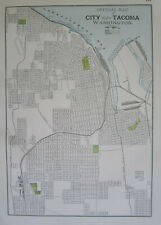 WA 1895 TACOMA WASHINGTON City Map Historic 19th Century 1800s Black White Blue
-
$75.00
 c1920 Clason Western Auto Supply Auto Trails Map Washington Two Sides Highways
-
$43.16
 Vintage 1886 WASHINGTON TERRITORY Map 13"x11" ~ Old Antique Original OLYMPIA WA
-
$45.95
 1911 Plat Map ~ Twp. 22N-34E - LINCOLN Co. WASHINGTON LAMONA - GREAT NORTHERN RR
-
$18.00
 US Geological Survey Map Scale 1/125000 Topographic Sheet Pasco Kennewick WA
-
$15.99
 1911 McNally Index Map - Washington - Seattle Spokane Olympia Tacoma Mt. Rainer
-
$20.68
 Old 1892 WASHINGTON STATE Authentic Atlas Map (14x21) Free S&H #P207
-
$45.95
 1888 Cram Atlas Indian Reservation & Railroad Map WASHINGTON TERRITORY (XL17x23)
-
$20.68
 1898 Cram's Atlas Map ~ TACOMA, WASHINGTON ~ Free S&H (11x14)
-
$20.68
 Vintage 1950 Atlas Map ~ WASHINGTON - OLYMPIA ~ Old & Authentic ~ Free S&H
-
$5.00
 1892 Popular Atlas of the World Map of Washington, Oregon, Utah and Arizona
-
$39.00
 1878 Western Hemisphere Mitchell antique map 15.1" x 12.1" - nice color
-
$18.00
 US Geological Survey Map Scale 1/62500 Topographic Sheet Reardan WA 1945
-
$59.99
 1914 YAKIMA INDIAN RESERVATION WASHINGTON MAPS SHOWING DAMS 4 MAPS!
-
$9.99
 1917 Poates Map - Washington - Seattle Tacoma Bellingham Olympia Mt. Rainer - WA
-
$14.40
 1911 Century Atlas Map Maryland Delaware Washington DC Baltimore Plans Annapolis
-
$45.95
 1913 Plat Map 4N-16E GOLDENDALE Twp. KLICKITAT Co. WA. / 2&3N-16E on Reverse
-
$11.99
 1937 McNally Map Seattle Washington Steamship Docks Pike Place Elliot Bay WA
-
$9.99
 1917 Poates Map - Washington - Olympia Seattle Port Townsend Tacoma Bellingham
-
$45.95
 1911 Plat Map Twp., 24N-36E - LINCOLN Co., WASHINGTON ~ ADRIAN KLOSTER LANDOWNER
-
$20.68
 Old 1882 Rand McNally Atlas Map ~ TERRITORY of WASHINGTO ~ Free S&H
-
$34.98
 1910 Antique Puget Sound Washington Port Townsend Land Classification Map 48x40
-
$149.99
 1903 Rand McNally Co. Map of Alaska and the Yukon Gold Fields Canada California
-
$24.95
 1888 Antique Tiny WASHINGTON Map MINIATURE Vintage State Map of Washington 1363


