 Antiques (US)
-
$100.11

 1861 Hand Colour Map Blackwood Greece Greek Isles Corfu Aegean Sea Mediterranean
-
$19.00
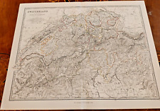
 Switzerland - Original 1895 Map by W & A.K. Johnston. Antique
-
$29.95
 Sweden & Norway (Scandinavia) antique map Keith Johnston 1860
-
$60.49
 1873 Keith Johnston Antique Hydrographic Maps x 2 of Great Britain & Ireland
-
$37.50
 c1900 Johnston Colour Atlas Map Basin of Mediterranean Sea Malta North Africa
-
$31.30
 1861 EGYPT Lower NUBIA Keith Johnston Royal Atlas 24 by 19 inches Large
-
$37.50
 c1900 Johnstons Atlas Map Sweden Norway Scandinavia Baltic Bothnia Gulf Atlantic
-
$31.30
 1861 EUROPEAN RUSSIA Keith Johnston Royal Atlas 24 by 19 inches Large
-
$37.50
 c1900 Johnston Atlas Colour Map Greece Cyclades Greek Islands Corfu Zante Aegean
-
$31.24
 c1900 Johnston Colour Atlas Map France Departments Environs of Paris Corsica
-
$100.11
 1861 Hand Coloured Map Blackwood Sweden Norway Scandinavia Baltic Sea Bothnia
-
$37.50
 1900 Johnston Colour Atlas Map Chart Empire of Germany Prussia Danzig Silesia
-
$100.11
 1861 Hand Colour Map Blackwood Europe Continent Russia UK Turkey Austria Nordic
-
$100.11
 1861 Hand Colour Map Blackwood France Regions Provinces Environs Paris Corsica
-
$100.11
 1861 Hand Coloured Map Blackwood Austrian Empire Hungary Croatia Transylvania
-
$62.54
 1861 Hand Coloured Map Blackwood Spain Portugal Balearic Mediterranean Pyrenees
-
$27.48
 c1900 Johnston Colour Atlas Map Empire Germany Southern Portion Bavaria Prussia
-
$72.62
 IRELAND, Keith Johnston large original Antique Map c1870
-
$31.24
 1900 Johnston Colour Atlas Map Chart Continent Europe Turkey Russia Austria UK
-
$87.59
 1861 Hand Coloured Map Blackwood Turkey in Europe Moldova Romania Serbia Balkans
-
$35.00
 c1900s Johnston Atlas Coloured Map Spain & Portugal Balearica Islands Gibraltar
-
$24.98
 1900 Johnston Colour Atlas Map Chart England & Wales Southern Pt Channel London
-
$31.24
 c1900 Johnston Colour Atlas Map Belgium & Netherlands Holland Luxemburg Brussels
-
$37.50
 c1900 Johnston Colour Atlas Map Switzerland Alps of Savoy & Piedmont Lake Geneva
-
$22.48
 1900 Johnston Colour Atlas Map Chart England & Wales Northern Part Isle Man Sea
-
$62.54
 1861 Hand Coloured Map Blackwood Switzerland Cantons Alps Savoy Piedmont Geneva
-
$37.50
 c1900s Johnston Atlas Colour Map Denmark North German Empire Schleswig Holstein
-
$59.99
 Prussia 1849 Original Map - Alexander Keith Johnston
-
$99.99
 Germany (Western States) 1850 Original Map - Alexander Keith Johnston
-
$99.99
 Belgium 1850 Original Map - Alexander Keith Johnston
-
$89.99
 Switzerland 1850 Original Map - Alexander Keith Johnston


