 Antiques (US)
-
$135.00

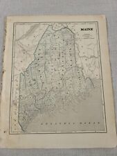 1842 Large Map of Maine. From Morse's North American Atlas. Color
-
$45.00
 1876 maps Canton, Massachusetts, from Norfolk County Atlas, with family names!
-
$25.00
 The Official Maps of New England L. Crocker Topographer, National Survey Co.
-
$1635.46
 1882 CITY ATLAS of BOSTON g. m. Hopkins Complete, 36 plates, mostly 2 page each
-
$25.49
 DeLorme Atlas & Gazetteer Map: MASSACHUSETTS 1998 First Edition
-
$24.64
 DeLorme Atlas & Gazetteer Map: CONNECTICUT & RHODE ISLAND 1999 First Ed. - CT RI
-
$51.00
 1877 map of Williamstown, Vermont from Atlas of Orange County, with family names
-
$51.00
 1877 map of Newbury Ctr, Corinth Center, Vermont from Atlas of Orange County, VT
-
$187.50
 ANTIQUE 1869 BROOKLYN TOWN, CANTERBURY VILLAGE, CT HAND COLORED MAP, O. W. GRAY
-
$51.00
 1877 map of Braintree, Vermont from Atlas of Orange County, with family names
-
$51.00
 Antique 1877 map of West Fairlee and Fairlee Vermont from Atlas of Orange County
-
$287.50
 MID-19TH C ANTIQUE 1860 HAND COLORED NEW ENGLAND MAP BY S. AUGUSTUS MITCHELL JR.


