 Antiques (US)
-
$32.46

 SHROPSHIRE original antique county map, Reform Bill, Ebden, Duncan, 1838
-
$11.24
 Antique/Vintage County Map of SHROPSHIRE - Phillips Handy Atlas , 1887
-
$4.99
 SHROPSHIRE (North) antique county map by GW BACON 1898 old chart
-
$4.99
 SHROPSHIRE (NORTH). Showing Parliamentary divisions & parks. BACON 1901 map
-
$82.40
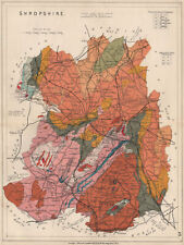 SHROPSHIRE Geological map. STANFORD 1913 old antique vintage plan chart
-
$4.99
 SHROPSHIRE (NORTH). Showing Parliamentary divisions & parks. BACON 1904 map
-
$18.73
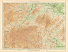 SHROPSHIRE HILLS Montgomery Shrewsbury Ludlow Clun Welshpool Wales 1939 map
-
$4.99
 SHROPSHIRE (NORTH) . Showing Parliamentary divisions & parks. BACON 1936 map
-
$18.73
 Shropshire Hills road map. Wenlock Ludlow Shrewsbury Welshpool. BACON c1920
-
$18.73
 W MIDLANDS/SEVERN VALLEY Birmingham Shropshire Hills Wolverhampton 1939 map
-
$32.46
 West Midlands Shropshire Hills Birmingham Northampton ORDNANCE SURVEY 1922 map
-
$12.49
 SHROPSHIRE HILLS. Montgomery Shrewsbury Ludlow Clun Welshpool Wales 1903 map
-
$18.73
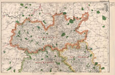
 SHROPSHIRE. Antique county map. Railways canals. Constituencies. PHILIP 1889
-
$4.99
 SHROPSHIRE (North) antique county map by GW BACON 1891 old chart
-
$32.46
 Shropshire Staffordshire Leics Notts Flintshire Derbys. ORDNANCE SURVEY 1922 map
-
$9.99
 SOUTH CENTRAL WALES. Brecon Beacons Shropshire Hills Plylimon Radnor 1898 map
-
$4.99
 SHROPSHIRE (SOUTH) . Showing Parliamentary divisions & parks. BACON 1936 map
-
$31.20
 1809 Antique Map; Shropshire, John Cary, New & Correct English Atlas
-
$12.49
 W MIDLANDS/SEVERN VALLEY. Birmingham Shropshire Hills Wolverhampton 1903 map
-
$4.99
 SHROPSHIRE (North). Antique county map by GW BACON 1884 old chart
-
$7.49
 SHROPSHIRE (SOUTH) . Showing Parliamentary divisions & parks. BACON 1900 map
-
$13.73
 SHROPSHIRE (South). Antique county map by GW BACON 1884 old chart
-
$6.24
 SHROPSHIRE (NORTH) . Showing Parliamentary divisions & parks. BACON 1896 map
-
$7.49
 SHROPSHIRE (SOUTH) . Showing Parliamentary divisions & parks. BACON 1896 map
-
$42.45
 Antique county map of SHROPSHIRE by JOHN CARY. Original outline colour 1793
-
$14.98
 CENTRAL WALES & SHROPSHIRE. Snowdonia south. Shrewsbury Montgomery 1898 map
-
$8.74
 SHROPSHIRE (SOUTH). Showing Parliamentary divisions & parks. BACON 1901 map
-
$24.96
 1824 Antique Map; Shropshire, John Cary, Shropshire Gazetteer
-
$4.99
 SHROPSHIRE (North). Antique county map by GW BACON 1884 old chart
-
$13.73
 SHROPSHIRE (South) antique county map by GW BACON 1883 old chart
-
$32.46
 SHROPSHIRE Large county map. Railways Wenlock Edge Stiperstones.WELLER 1863
-
$9.99
 SHROPSHIRE (SOUTH). Showing Parliamentary divisions & parks. BACON 1904 map
-
$34.95
 SHROPSHIRE HILLS. Montgomery Shrewsbury Ludlow Clun Welshpool Wales 1939 map
-
$88.65
 SHROPSHIRE Geological map. STANFORD 1904 old antique vintage plan chart
-
$58.68
 Shropshire Cir1863 map Dispatch Atlas Drawn/Engraved by E.Weller Framed 60 more
-
$41.20
 NORTH WALES & NW ENGLAND. Shropshire Merseyside Cheshire. SDUK 1845 old map
-
$106.13
 Shropshire. 'SHROP SHIRE' by ROBERT MORDEN from Camden's Britannia 1772 map


