 Antiques (US)
-
$73.25

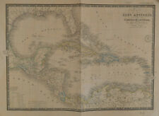 BRUÉ Map of Caribbean Carte des Isles Antilles des Etats Unis de L'Amérique 1860
-
$112.94
 Antique Map "Carta dell'isola di S. Cristoforo" (St Kitts Island) Bellin, 1770
-
$276.07
 Antique Map "Piano della Città di S. Domingo" (Dominican Republic)G. Pazzi, 1763
-
$156.86
 Antique "Map of the Island of St. Christopher's" (Saint Kitts and Nevis) 1794
-
$219.60
 Map "A Plan of the Siege of the Havana drawn by an Officer on the Spot, 1762"
-
$156.86
 ANTIQUE ADMIRALTY CHART. No.657, PANAMA CANAL and APPROACHES, 1915 Edition.
-
$61.49
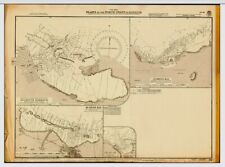
 VINTAGE ADMIRALTY CHART. No.587. BURICA POINT to MANGROVE BLUFF. 1914 Edn
-
$1450.00
 Yucatan Antique Map partie de la Nouvelle Espagne et Guatimala Montanus 1671
-
$94.11
 Antique Map "Carta Esatta Rappresentante L'Isola di Granata" M. Coltellini, 1763
-
$43.92
 VINTAGE ADMIRALTY CHART. No. 451. Plans in NORTH WEST JAMAICA. 1933 Edition.
-
$250.97
 Antique Map "Carta Esatta Rappresentante l'Isola della Guadalupa" G. Pazzi, 1777
-
$549.99
 Original 1831 Friesz Nautical Map GUADELOUPE Marie-Galante Desirade Caribbean
-
$56.47
 VINTAGE ADMIRALTY CHART. No.697. DOMINICA. 1914 Edition.
-
$941.14
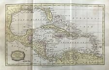
 Map "Mappa Geographica, complectens I. Indiae Occidentalis" Homann Heirs, 1740
-
$62.73
 1839 Antique Map; West Indies: Caribbean, Florida, Venezuela after John Russell
-
$43.91
 1807 Antique Map; The West Indies by James Barlow, Early Colour


