 Antiques (US)
-
$48.88

 1889 Switzerland Map ORIGINAL Zurich Geneva Bern Cantons Townships Railroads
-
$38.88
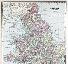
 1897 England and Wales Map Cornwall Dorsey Cardiff Portsmouth Hastings Bristol
-
$38.88
 OLD 1899 Southern England Wales Map London Cornwall STEAMSHIPS RAILWAYS PORTS
-
$48.00
 ENGLAND WALES Map 1889 ORIGINAL London Dover Railways Counties Townships G. CRAM
-
$39.99
 1814 John Cary Road Map Cornwall Lands End Truro St. Ives Falmouth England UK
-
$74.60
 CORNWALL DEVON ROAD MAP BY JOHN OGILBY REDUCED BY THOMAS GARDNER c1719
-
$9.99
 1892 Crowell Kirkpatrick Map - England & Wales London Liverpool Bristol Cornwall
-
$17.93
 1896 Cornwall large antique map. 128 years old. Penzance, St Austell, Falmouth.
-
$93.25
 Emanuel Bowen : A Map of Cornwall. 1720
-
$8.08
 1902 Map of Cornwall Devon Dorset Channel Island antique vintage Britannica 10th
-
$39.95
 Vintage framed Hand Stitched Map Of England And Wales 20.5" x 16.5"
-
$75.00
 1876 British Isles antique map ~ 27.5" x 19.6" hand colored - Scotland & Ireland
-
$24.85
 1955 Antique Map; Admiralty Chart 2649 English Channel Western Portion
-
$43.52
 100% ORIGINAL CORNWALL FOX HUNTING MAP BY HOBSON C1860/S VGC COLOURED
-
$74.50
 Cornwall Atlantic Ocean English Channel Brass Map Framed Coppercraft BB203
-
$60.92
 VINTAGE ADMIRALTY CHART. No. 1168. NORTH COASTS of DEVON, CORNWALL. 1954 Edn.
-
$99.99
 1853 Falmouth Harbour Antique Sea Chart Coastal Map England South UK (1856)
-
$77.42
 History Map of Cornwall 1758 Framed 19” *25” #1
-
$15.70
 1906 antique South Cornwall road map. Mevagissey, Bodwin, Lostwithiel, Fowey.
-
$15.00
 Map Cornwall England UK
-
$4.97
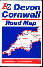 A-to-Z Map - Devon & Cornwall
-
$80.82
 Antique map of Cornwall by Alexander Hogg and Thomas Conder 1784
-
$29.43
 1922 VINTAGE MAP OF WESTERN ENGLAND CORNWALL DEVON SOMERSET WALES UNITED KINGDOM
-
$62.17
 STH CORNWALL.Falmouth Truro Fowey Bodmin Liskeard Looe St Austell.CARY 1794 map
-
$31.07
 DEVON CORNWALL PLYMOUTH LOOE BY EMANUEL BOWEN c1720 GENUINE ANTIQUE MAP
-
$21.14
 Original antique road map CORNWALL, HAMPSHIRE, TRURO, PENZANCE, Paterson, 1785
-
$93.25
 Antique map of Cornwall by Richard Blome 1715
-
$130.55
 Antique Map of Cornwall by John Cary 1813
-
$60.92
 ANTIQUE ADMIRALTY CHART. No.1564. WHITSAND BAY, CORNWALL. 1890 Edition.
-
$25.16
 Vintage 1900 IRELAND Map 11"x14" ~ Old Antique Original DONEGAL DUBLIN GALWAY
-
$24.19
 1835 J & C Walker Antique Map City Plan St Ives, Cornwall, England - Green Matt
-
$60.92
 CORNWALL DEVON DODMAN POINT TO START POINT VINTAGE ADMIRALTY CHART MAP 1955
-
$18.90
 1908 ORIGINAL ANTIQUE MAP OF WESTERN ENGLAND CORNWALL DEVON WALES
-
$34.81
 Original antique road map CORNWALL, LANDS END, DEVON, PLYMOUTH, Laurie, 1823
-
$37.30
 Vintage map of Cornwall, by Christopher sexton, dated 1575.
-
$18.59
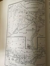
 1898 North Devon, East Cornwall, Barnstaple & Bude Bay large map. 125 years old.
-
$24.89
 1912 ANTIQUE MAP OF ENGLAND LONDON / WALES CORNWALL DEVON SOMERSET SUSSEX
-
$19.99
 1830 Nathan Hale Map - England & Wales - London Liverpool Cornwall Dover Bristol
-
$73.36
 ANTIQUE ADMIRALTY CHART. No.442. LIZARD HEAD to START POINT. 1913 Edition.
-
$62.16
 Old Ordnance Survey Map of the Neighbourhood of Lizard Scale One Inch to a Mile
-
$4.04
 VINTAGE SEA CHART / NAUTICAL MAP 1961 - Hamble River - To Frame?
-
$43.52
 DEVON, PLYMOUTH DOCK, CORNWALL, ST GERMANS, original antique map, MOGG, 1817
-
$155.42
 1693 Greenvile Collins Sea Chart Lands End Cornwall Scilly Islands Antique Map
-
$23.76
 1921 ANTIQUE MAP OF CORNWALL DEVON DORSET SOMMERSET / YORK LINCOLN ENGLAND
-
$27.75
 Vintage Color Map ~ BRITISH ISLES ~ ENGLAND IRELAND SCOTLAND WALES Printed 1883
-
$16.31
 1895 Cornwall county map. Victorian print. Penzance, Truro, Bodmin, Launceston.
-
$12.42
 1928 Land's End and Lizard Map OS Contoured Cloth No 146 Vintage
-
$93.25
 Antique map of Cornwall by Robert Morden 1720
-
$4.04
 VINTAGE SEA CHART / NAUTICAL MAP 1961 Ireland Arklow Ardglass Killough Rosslare
-
$43.52
 CORNWALL, FRADDON, ST ERME, TRURO, original antique map, MOGG, 1817
-
$43.52
 CORNWALL, TRURO, FALMOUTH, PENDENNIS CASTLE, original antique map, MOGG, 1817
-
$4.04
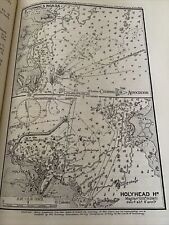 VINTAGE SEA CHART / NAUTICAL MAP 1961 - St Tudwal’s & Holyhead - To Frame?
-
$23.00
 Original antique road map DEVON, BARNSTAPLE, CORNWALL, CAMELFORD, Bowen c.1724
-
$99.47
 CORNWALL original antique county map, Reform Bill, W. Ebden, J. Duncan, 1838
-
$3.72
 VINTAGE SEA CHART / NAUTICAL MAP 1961 - Ireland - Kinsale - To Frame?
-
$28.00
 1830 Nathan Hale Map England Wales London Liverpool Oxford Cornwall Bristol UK
-
$19.00
 1859 Antique Color MITCHELL Map ~ EUROPE ~ Original ~ Extremely Rare
-
$4.04
 VINTAGE SEA CHART / NAUTICAL MAP 1961 - Mersea Quarters- To Frame?
-
$4.04
 VINTAGE SEA CHART / NAUTICAL MAP 1961 Ireland - Westport Bay - To Frame?
-
$27.35
 TOURING MAP OF DEVON AND CORNWALL. South West England. WARD LOCK 1951 old
-
$4.04
 VINTAGE SEA CHART / NAUTICAL MAP 1961 - The Wash - To Frame?
-
$6.15
 2 Vintage WW2 maps PADSTOW to HARTLAND POINT to MILFORD HAVEN 1943
-
$596.81
 map of Cornwall Schenk and Valk coastal map mounted framed original c1700
-
$994.68
 Antique Map "The Spanish Armada entering the English Channel" John Pine, 1739
-
$354.35
 Antique Map of Cornwall by Christopher Saxton and William Kip 1637
-
$4.04
 VINTAGE SEA CHART / NAUTICAL MAP 1961 - TORQUAY & BRIXHAM Harbours - To Frame?
-
$4.04
 VINTAGE SEA CHART / NAUTICAL MAP 1961 - France - Lezardrieux
-
$4.04
 VINTAGE SEA CHART / NAUTICAL MAP 1961 - France - Brest Approaches
-
$29.90
 Antique Map - "Cornwall" by J Wallis published 1812 by J Wallis 4"x5.5"
-
$55.95
 Antique map of Derbyshire by John Seller 1701
-
$36.06
 ANTIQUE ADMIRALTY CHART. No.3418. St GERMANS to LYNHER RIVER. 1904 Edition.
-
$43.52
 HAMPSHIRE, FARNHAM, SOUTHAMPTON, CORNWALL, antique road map, SENEX, 54-55, 1762
-
$21.14
 Par sands & harbour sea coast chart. Cornwall. ADMIRALTY 1943 old vintage map
-
$4.04
 VINTAGE SEA CHART / NAUTICAL MAP 1961 - Ireland - Baltimore & Crookhaven
-
$19.96
 1879 Perron map: Falmouth and Truro, Cornwall, England (#88)
-
$15.37
 1896 North Devon & North East Cornwall map. England. Barnstable, Bideford.
-
$100.00
 ST MICHAEL'S MOUNT CORNWALL ELIZABETH BYRNE 19TH CENTURY LARGE ENGRAVED VIEW
-
$60.92
 ANTIQUE ADMIRALTY CHART. No.1178. TREVOSE HEAD to BULL POINT. 1920 Edition.
-
$43.52
 CORNWALL, SUSSEX, BRIGHTON, antique road map, SENEX, OGILBY, Pl 28-29, 1762
-
$19.89
 GEORGE COLE c1835: Cornwall
-
$41.03
 Penryn and Falmouth, Cornwall. JAMES. Parliamentary Boundary Commission 1868 map
-
$8.39
 North Devon Exmoor Vintage Bartholomews Map 1968 Half Inch Old Tiverton Exeter
-
$105.68
 Antique Map of South West England by Petrus Bertius 1618
-
$24.87
 Bartholemews historical Map of England and Wales and two Linen maps Cornwall etc
-
$4.04
 VINTAGE SEA CHART / NAUTICAL MAP 1961 - River Blackwater - To Frame?
-
$21.14
 FALMOUTH vintage city/town plan. Cornwall. WARD LOCK 1948 old vintage map
-
$4.04
 VINTAGE SEA CHART / NAUTICAL MAP 1961 - Chichester - To Frame?
-
$4.04
 VINTAGE SEA CHART / NAUTICAL MAP 1961 - France - Douarnenez & Audierne
-
$11.99
 Bartholomew 1888 Shire Map CORNWALL Penzance Falmouth Lands End Helstone England
-
$99.00
 1840 British Isles map by Greenleaf 14.2" x 11.9" scarce 1st edition antique
-
$21.14
 PENZANCE vintage tourist town city plan. Cornwall. WARD LOCK 1944 old map
-
$37.29
 DEVON CORNWALL LAUNCESTON BARNSTAPLE BY EMANUEL BOWEN GENUINE ANTIQUE c1720
-
$5.28
 PAR, Cornwall - Rare Vintage WW2 Naval Military Map 1943
-
$4.04
 VINTAGE SEA CHART / NAUTICAL MAP 1961 - Barnstaple Bideford Ilfracombe
-
$25.00
 1876 British Isles map antique ~ 17.3" x 13.8" hand color & US Census maps
-
$4.04
 VINTAGE SEA CHART / NAUTICAL MAP 1961 - Holland - Flushing Breskens Groningen
-
$22.37
 Antique/Vintage Map of Changes in Cultivation in Cornwall 1485 - 1952
-
$4.04
 VINTAGE SEA CHART / NAUTICAL MAP 1961 - Dieppe, Havre, Trouville, Ouidtreham,
-
$21.76
 Thomas Moule C1835 Antique Map. Cornwall
-
$18.65
 BOCONNOC PARISH CORNWALL TITHE ESTATE SURVEY LAND USE 1838 FINE MOUNTED MAP


