 Antiques (US)
-
$5.61

 Vintage Ordnance Survey sheet Map NY 21 Borrowdale Cumbria 1:25,000 dated 1963
-
$11.22
 Antique Map Dated 1955 On Cloth Barrow In Furness Ordnance Survey National Grid
-
$24.97
 Vintage Lake District 3 x 2 maps Bartholomew & Ward locke & co Guide book
-
$36.17
 Vintage Contoured Map Lake District Windermere & Ulverston CLOTH BACKED 1925
-
$9.36
 1962 Ordnance Survey THE LAKE DISTRICT One-Inch Tourist Map Cumbria VG Cond
-
$14.36
 Vintage Retro Ordnance Survey Map - Carlisle - 1 inch - No 76 - 7th Series
-
$18.72
 ORDNANCE SURVEY CLOTH TOURIST MAP OF THE LAKE DISTRICT 1" TO 1 MILE 1920
-
$12.47
 Bartholomew's Survey Map of THE ENGLISH LAKES (c1950) Sheet 34, England, Cloth
-
$15.92
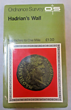 Vintage Retro Ordnance Survey Map - Hadrians Wall - 2 inch to 1 Mile Historical
-
$12.49
 1913 LAKE DISTRICT CUMBRIA Ordnance Survey Cloth Map - Half Inch to 1 Mile - #5
-
$37.44
 Vintage Contoured Map The Lake District Cumbria Windermere CLOTH BACKED 1930s
-
$36.17
 Vintage Map Lake District Keswick & Ullswater CLOTH BACKED c.1920s 1930s
-
$37.46
 Sheet 18 WASDALE. Cumbria Wastwater Millom Sellafield. ORDNANCE SURVEY 1932 map
-
$36.17
 Vintage Contoured Map Wharfedale Yorkshire CLOTH BACKED c.1920s 1930s
-
$51.19
 North Pennines. Cumbria Durham Tyneside Dumfries ORDNANCE SURVEY 1922 old map
-
$14.98
 Vintage 2 x Ordnance Survey Maps, Penrith & Keswick, Unused.
-
$6.18
 Lake District Touring Map Sheet 3 1:63,360
-
$37.46
 War Revision Sheet 9 CARLISLE. Cumbria. ORDNANCE SURVEY 1940 old vintage map
-
$12.47
 ORDNANCE SURVEY WALL CHART / MAP - LANCASTER & KENDAL #89 1" : 1 MILE Cumbria
-
$6.24
 English Lakes Bartholomew's Revised Half Inch Contoured Map Sheet 34
-
$46.20
 English Lake District & Isle of Man. Cumbria Lancashire ORDNANCE SURVEY 1922 map
-
$9.36
 7 x Maps Of North England Lake District Ordnance Survey & Others Job Lot Bundle
-
$12.47
 ORDNANCE SURVEY WALL CHART/ MAP BARROW IN FURNESS cumbria #88 1": 1 MILE 1965
-
$18.72
 Georgian Map of Kirkby Kendal, Cumbria (1831) Robert Dawson Parliament Borough
-
$8.43
 1964 Ordnance Survey Map Penrith In Cumbria Sheet 83 Orienteering Hiking Cycling
-
$1.87
 Ordnance Survey Outdoor Leisure Map: The English Lakes, North West Sheet
-
$14.97
 VINTAGE ORDNANCE SURVEY MAP - Lancaster & Kendal (1965) Sheet 89 - Lake District
-
$59.93
 Agricultural Land Classification 88 Cumbria Coastal plain & High Fells 1968 map
-
$24.96
 The Lake District (c1930s) Vintage Ordnance Survey Folding Map, Cumbria, England
-
$6.23
 CARLISLE ordnance SURVEY MAP - Sheet 85 - LANDRANGER Ordnance Survey Map
-
$82.40
 Agricultural Land Classification 82 Cumbria coastal plain Lake District 1971 map
-
$37.44
 THE LAKE DISTRICT MAP - Ordnance Survey Map - 1948
-
$16.17
 ORDNANCE SURVEY CLOTH ANTIQUE UK MAP 1932 THE LAKE DISTRICT
-
$9.98
 Ordnance Survey Landranger Map - Kendal to Morcambe, Cumbria, England - Sheet 97
-
$12.47
 Vintage Ordnance Survey Map - Three Peaks - Whernside, Ingleborough, Pen-y-Ghent
-
$8.73
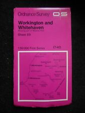 Ordnance Survey Map - Workington & Whitehaven - Cumbria, Cockermouth - Sheet 89
-
$12.47
 Vintage Ordnance Survey Map - English Lakes (North East) Ullswater, Haweswater


