 Antiques (US)
-
$5.46

![1950s The Motor, Map of England, Southern Scotland, 37x27cm [26785]](https://i.ebayimg.com/thumbs/images/g/ALIAAOSwpJxj2Upw/s-l225.jpg) 1950s The Motor, Map of England, Southern Scotland, 37x27cm [26785]
1950s The Motor, Map of England, Southern Scotland, 37x27cm [26785]
-
$61.18
 ANTIQUE ADMIRALTY CHART. No. 1346. THE FIRTH of SOLWAY. 1890 Edition.
-
$61.18
 ANTIQUE ADMIRALTY CHART. No.1826. SOUTHPORT to CARLISLE . 1915 Edition.
-
$9.98
 LAKE DISTRICT, CUMBRIA, WESTMORLAND - 1930 Antique Map by Bartholomew
-
$624.28
 Antique/Vintage Ward Lock & Co's Motoring & Touring Map Lake District
-
$14.36
 Vintage Retro Ordnance Survey Map - Carlisle - 1 inch - No 76 - 7th Series
-
$61.18
 VINTAGE ADMIRALTY CHART. No.1826. BURROW HEAD to LIVERPOOL . 1953 Edition.
-
$15.92
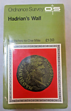 Vintage Retro Ordnance Survey Map - Hadrians Wall - 2 inch to 1 Mile Historical
-
$14.98
 Vintage 2 x Ordnance Survey Maps, Penrith & Keswick, Unused.
-
$11.22
 Vintage Roadmap - 30.5" X 40" - Cumbria, Fleetwood, Lancaster, Isle Of Man
-
$6.18
 Lake District Touring Map Sheet 3 1:63,360
-
$9.36
 7 x Maps Of North England Lake District Ordnance Survey & Others Job Lot Bundle
-
$12.47
 ORDNANCE SURVEY WALL CHART / MAP - LANCASTER & KENDAL #89 1" : 1 MILE Cumbria
-
$6.24
 English Lakes Bartholomew's Revised Half Inch Contoured Map Sheet 34
-
$12.47
 ORDNANCE SURVEY WALL CHART/ MAP BARROW IN FURNESS cumbria #88 1": 1 MILE 1965
-
$6.87
 Bartholomew Lake District One Inch Map Vintage
-
$14.97
 VINTAGE ORDNANCE SURVEY MAP - Lancaster & Kendal (1965) Sheet 89 - Lake District


