 Antiques (US)
-
$24.91

 1885 British Isles & North Sea Antique Map by John Bartholomew & George Philip
-
$24.91
 1902 Cork, Killarney, Dublin & Wicklow Original Antique Map by John Bartholomew
-
$36.29
 1890 John Bartholomew Large Antique Map of Ireland, Belfast & Cork
-
$24.91
 1898 CORK, KILLARNEY, KERRY, LIMERICK IRELAND ANTIQUE COLOUR MAP BY BARTHOLOMEW
-
$20.76
 1888 ORIGINAL ANTIQUE BATHY-OROGRAPHICAL MAP OF UNITED KINGDOM ENGLAND IRELAND
-
$9.50
 1907 British Isles Railway Map
-
$6.23
 1888 Map of environs Glengarriff Kenmare Bantry Ireland antique chromolithograph
-
$13.99
 Vintage 1930's Map of Ireland Showing LMS Connections 12" x 13" London Midland S
-
$6.23
 1888 Map of the Environs of Kilkee Ireland antique chromolithograph
-
$33.97
 1888 ANTIQUE MAP LONDON TUBE RAILWAYS ENGLAND DUBLIN IRELAND EDINBURGH SCOTLAND
-
$6.23
 1888 Map of Youghal to Lismore Ireland antique chromolithograph
-
$33.02
 Guinness Original Hibernia Regnvm Vulgo Ireland Poster Printed By John...
-
$6.23
 1888 Map of Glendalough and the Seven Churches Ireland antique chromolithograph
-
$24.00
 2 x England Maps 1922: British Isles / England Wales Times Atlas - Bartholomew
-
$60.49
 1870 John Bartholomew Large Antique 2 Sheet Map of Ireland
-
$36.29
 1890 John Bartholomew Large Antique Map of Cork, Killarney Dublin - Ireland
-
$6.23
 1888 Map of Killarney Lough Leane Ireland antique chromolithograph
-
$6.23
 1888 Map of Killarney district Ireland antique chromolithograph
-
$6.23
 1888 Map of Dargle and Powerscourt Ireland antique chromolithograph
-
$6.23
 1888 Map of Connemara northern section Ireland antique chromolithograph
-
$9.96
 IRELAND 3 County Maps - Bartholomew's Revised Quarter-Inch Series V/G
-
$43.62
 Antique Framed Citizen's Atlas World Map from the 1890's Cork Dublin Ireland
-
$14.95
 Vintage map of UK BRITAIN ENGLAND BRITISH ISLES - 1930s, approx A3 size - VGC
-
$31.15
 John Bartholomew: LMS Map of England and Wales. 1920
-
$7.46
 Batholomew's AA Quarter Inch Map of Ireland DUBLIN and ATHLONE Sheet 6 1950's
-
$9.99
 Original 1896 BATHY-OROGRAPHICAL Map BRITISH ISLES Ocean Depths Mountain Heights
-
$19.95
 Vintage JOHN BARTHOLOMEW & SON LTD. Tourist Map Of Britain & Northern Ireland
-
$14.95
 Vintage map IRELAND, NORTHERN, EIRE, IRISH FREE STATE - 1930s, c. A3 size - VGC
-
$36.29
 1870 John Bartholomew Large Antique Map of Great Britain & Ireland, NW Europe
-
$12.46
 Southern Ireland - 1900 Antique Small Map by Bartholomew - Mounted Matted
-
$12.46
 British Isles - 1900 Antique Small Map by Bartholomew - Mounted Matted
-
$12.46
 British Isles Railway - 1900 Antique Small Map by Bartholomew - Mounted Matted
-
$14.95
 BARTHOLOMEW'S NEW REDUCED SURVEY TOURISTS & CYCLIST SHEET 6 DUBLIN AND ATHLONE
-
$2.10
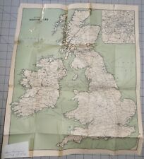
 Handy Map of Britain & Ireland by John Bartholomew


