 Antiques (US)
-
$14.99

 VINTAGE MAMMOTH CAVE KY KENTUCKY ORIGINAL 1922 USGS 17X21 QUADRANGLE MAP
-
$11.04
 USGS Topographic Map 1977 Survey 30"x60" KT Hazard 37083-A1-TM-100
-
$11.04
 USGS Topographic Map 1986 Survey 30"x60" KT Campbellsville 37085-A1-PL-100
-
$11.04
 USGS Topographic Map 1981 Survey 30"x60" KT Elizabethtown
-
$19.99
 Vintage 1956 Original Kentucky Map US Dept Of Interior 30x15
-
$9.95
 Vintage 1975 USGS Topo Map Mammoth Cave FLINT MAMMOTH CAVE SYSTEM 8.5" X 11"
-
$18.95
 Vintage 1947 State Map Print Suitable For Framing Louisiana Kentucky Tennessee
-
$60.00
 Kentucky and Tennessee c.1880's large lithographed hand color old map 2 sheets
-
$16.00
 Map War Of 1812 Indian Wars 1871 Victorian Lithograph History Swinton DWAA12
-
$12.00
 Map War Secession West Operations 1871 Victorian Woodcut Print History DWAA12
-
$6.00
 1897 Map East part of United States Original antique print
-
$29.90
 1903 Antique Map Scott County Kentucky Georgetown Turkey Foot 20X26 #4266
-
$24.90
 1903 Antique Map Kentucky Mason County Maysville Lewsiburg 22 X 22 #9952
-
$11.04
 USGS Topographic Map 1991 Survey 30"x60" KT Harrodsburg 37084-E1-TM-100
-
$11.04
 USGS Topographic Map 1982 Survey 30"x60" KT Irvine
-
$11.04
 USGS Topographic Map 1980 Survey 30"x60" KT, TN Hopkinsville
-
$9.95
 Richmond KY Madison County USGS Topographical Geological Survey Quadrangle Map
-
$39.99
 1940's Army topo map Waverly Kentucky -Sheet 3459 III NE Camp Breckinridge
-
$6.00
 1897 Map of United States & Mexico Original antique print
-
$9.95
 Offutt Kentucky Johnson Co. USGS Topographical Geological Survey Quadrangle Map
-
$25.94
 Antique County Map of KENTUCKY & TENNESSEE (Virginia & West Virginia on Back)
-
$29.99
 1940's Army topo map Hiatt Kentucky -Sheet 3357 I SW
-
$19.99
 1940's Army map Rushing Kentucky -Sheet 3357 II NE Murray
-
$29.99
 1940's Army topo map Sebree Kentucky -Sheet 3459 II Camp Breckinridge
-
$19.99
 1940's Army map Hamlin Kentucky -Sheet 3357 II SE
-
$29.99
 1940's Army topo map Hico Kentucky -Sheet 3357 II NW
-
$9.95
 Brownfield IL Pope Co. USGS Topographical Geological Survey Quadrangle Old Map
-
$29.90
 1903 Antique Map Mason County Kentucky Maysville Lewisburg Dover 22X22 #4267
-
$44.66
 1872 Map of KENTUCKY & TENNESSEE, Hand Colored
-
$9.95
 New Haven IL Gallatin Co USGS Topographical Geological Survey Quadrangle Old Map
-
$20.56
 Original antique map, USA, AMERICA, KENTUCKY, Shaffner, Woolley, 1863
-
$39.90
 1902 Antique Map Kentucky Union County Uniontown Sturgis 26 X 31" #8785
-
$29.99
 1940's Army topo map Vine Grove Kentucky -Sheet 3859 IV Radcliff Fort Knox
-
$49.99
 1940's Army (like USGS) topo map Fort Knox Kentucky w/ aerial -Sheet 3859 IV NW
-
$39.99
 1940's Army (like USGS) topo map Colesburg Kentucky -Sheet 3859 IV SE Fort Knox
-
$19.99
 MAMMOTH CAVE KY KENTUCKY ORIGINAL 1922 USGS 17X21 QUADRANGLE MAP EXCELLENT COND.
-
$39.99
 1940's Army topo map Guston Kentucky -Sheet 3759 I NW
-
$39.99
 1940's Army topo map Rock Haven Kentucky -Sheet 3759 I NE Fort Knox
-
$6.00
 1897 Map North part of United States Original antique print USA
-
$15.00
 Vintage Kentucky - Illinois Cave In Rock Quadrangle Topo Map
-
$39.99
 1940's Army topo map Big Spring Kentucky -Sheet 3759 I SW
-
$39.99
 1940's Army topo map Flaherty Kentucky -Sheet 3759 I SE
-
$39.99
 1940's Army topo map Lodiburg Kentucky -Sheet 3759 IV NW
-
$39.99
 1940's Army topo map Bordley Kentucky -Sheet 3459 III SE
-
$39.99
 1940's Army topo map Garfield Kentucky -Sheet 3759 IV SE
-
$39.99
 1940's Army topo map Morganfield Kentucky -Sheet 3459 III NW
-
$39.99
 1940's Army topo map Sturgis Kentucky -Sheet 3459 III SW
-
$39.99
 1940's Army topo map Sebree Kentucky -Sheet 3459 II SE Camp Breckinridge
-
$39.99
 1940's Army topo map Irvington Kentucky -Sheet 3759 IV NE
-
$39.99
 1940's Army topo map Pitts Point Kentucky -Sheet 3859 IV NE Fort Knox
-
$39.99
 1940's Army topo map Hardinsburg Kentucky -Sheet 3759 IV SW
-
$39.99
 1940's Army topo map Dixon Kentucky -Sheet 3459 II SW Camp Breckinridge
-
$39.99
 1940's Army topo map Poole Kentucky -Sheet 3459 II NW Camp Breckinridge
-
$39.99
 1940's Army topo map Robards Kentucky -Sheet 3459 II NE
-
$29.99
 Mammoth Cave KY Quadrangle Vintage Original USGS Topographic Map1957 Print
-
$49.99
 1940's Army topo map Vine Grove Kentucky -Sheet 3859 IV SW Radcliff Fort Knox
-
$45.00
 1877 Coast & Geodetic Survey Triangulation Map #24 Kentucky & Indiana
-
$30.00
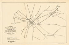 Map of Camp Hamilton, Lexington Kentucky, 1898


