 Antiques (US)
-
$200.00

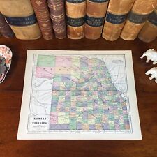
 1867 Kansas Colorado Montana & Dacota Hand Colored Map 13 x 15 Mitchell Antique
-
$74.99
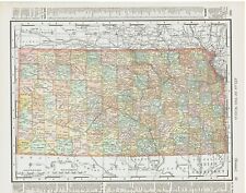
 Lot 7 antique U. S. State maps Wyoming Idaho Washington Nebraska Railroads B24
-
$28.04
 Vintage 1901 NEBRASKA Map 22"x14" ~ Old Antique Original GERING LINCOLN OMAHA NE
-
$49.99
 Johnson's Iowa Nebraska Hand Colored Map 1864 B21
-
$175.00
 Civil War Map Utah Military Department Colorado Nevada California Salt Lake City
-
$16.00
 Midwestern USA - Original 1909 Map by John Bartholomew. Antique
-
$18.00
 Nebraska - Original 1910 Dated Map by Dodd Mead & Company. Antique
-
$99.00
 1878 Colorado Montana Dakota & Wyoming Mitchell antique map 22.9" x 15.1"
-
$95.00
 1862 Johnson Dakota Nebraska Kansas Colorado antique map 17.4" x14.2" nice color
-
$38.88
 1916 UNITED STATES Map ORIGINAL Rainfall Colorado Montana Michigan Wisconsin
-
$48.88
 1916 UNITED STATES Map ORIGINAL LARGE Wisconsin Indiana Pennsylvania Delaware
-
$14.99
 1893 Arkansas & Nebraska Maps Gaskell's Family & Business Atlas antique vintage
-
$11.95
 Vintage NEBRASKA Map Wall Art Old Original 1930s Decor Omaha North Platte
-
$99.99
 Lot 11 antique U. S. State maps California Minnesota Florida Alaska Dakotas B25
-
$28.00
 1879 Map West Central States Group Victorian Atlas Geography 1st Edition DWAA9
-
$28.76
 Vintage 1901 NEBRASKA Map 22"x14" ~ Old Antique Original GERING LINCOLN MADISON
-
$18.00
 Nebraska - Original 1907 Dated Map by Dodd Mead & Company. Antique
-
$14.99
 Original 1899 Map NEBRASKA Lincoln Omaha Railroads Grand Island Platte River
-
$45.95
 Old 1897 Map ~ NEBRASKA ~ Authentic Atlas Map (XXL22x29) Free S&H -#033
-
$15.00
 Antique 1889 Map Nebraska / Kansas by George F Cram Unrivaled Family Atlas 13x10
-
$19.95
 CENTURY ATLAS MAP PLATE #29 "NEBRASKA" OMAHA MIDWEST 1911 ANTIQUE ORIGINAL
-
$45.95
 1889 Map ~ NEBRASKA ~ (XL17x23) Colored - Good Condition - Free S&H -#014
-
$33.60
 Original 1885 Antique Map KANSAS NEBRASKA Wichita Topeka Lincoln Fremont Kearney
-
$9.99
 CRAM'S ATLAS CITY STREET MAP PAGE OMAHA NEBRASKA & COUNCIL BLUFFS 1890 VINTAGE
-
$14.99
 Original 1901 Streetcar Map OMAHA Nebraska Meat-Packing Plants Railroads Parks
-
$8.95
 Antique Original 1915 Map: Nebraska and on the reverse Kansas
-
$11.04
 USGS Topographic Map 1985 Survey 30"x60" NE Scottsbluff 41103-E1-TM-100
-
$28.80
 Large Original 1898 Antique Map NEBRASKA Omaha Lincoln Bellevue Kearney Hastings
-
$87.00
 1949 United States Map ORIGINAL West Indies America Mexico Florida Great Lakes
-
$11.04
 USGS Topographic Map 1985 Survey 30"x60" NE Hemingford 42103-A1-TM-100
-
$15.86
 1903 State Map of Nebraska and Iowa Sharp Colors Highly Detailed 21.5" x 13.5
-
$14.00
 Antique Map Holt County, Nebraska O'Neill, Page, Chambers- part; 1915 Atlas
-
$13.86
 1885 Antique Color Map North Central States Western Section ND SD MN NE IA KS MO
-
$4.99
 1949 state maps Nevada and Nebraska 14x11" sheet counties cities towns
-
$14.49
 VTG USGS Map Browns Creek Quadrangle Nebraska 1943 20 x 16"
-
$12.49
 1949 Britannica Map - Nebraska - Omaha Lincoln Lincoln Sioux City Scotts Bluff
-
$13.86
 1899 Color Map States of Kansas & Nebraska Very Clean Detailed Near Mint Map
-
$9.99
 MONARCH STANDARD ATLAS MAP PAGE PLATE OF NORTH DAKOTA & NEBRASKA 1906 VINTAGE
-
$14.00
 1915 Plat Map Holt County, Nebraska, Twsp 25-10 Lake & Deloit precincts Ancestry
-
$14.00
 1915 Plat Map Holt County, Nebraska Twsp 25-11 Lake precinct Ancestry
-
$12.95
 1911 Antique Rand McNally Map of NEBRASKA w/copy History/Demographics
-
$14.99
 Original 1884 Map NEBRASKA Sioux County Lincoln Omaha Grand Island Railroads
-
$4.21
 Vintage 1951 Nebraska Highway Road Map Shell Oil Gas Station
-
$45.00
 1862 Johnson Iowa & Nebraska antique map 17.6" x 14.2" nice color
-
$16.99
 Original 1891 Streetcar Map OMAHA Nebraska Meat-Packing Plants Railroads Parks
-
$7.99
 CENTURY ATLAS MAP PAGE PLATE NO. 29 STATE OF NEBRASKA 1911 VINTAGE
-
$49.99
 Large Format 1905 COLOR Rand McNally Map Atlas Page 226&227 Railroads Nebraska
-
$749.99
 Original 1852 Stansbury UTAH TERRITORY & GREAT PLAINS Exploration and Survey Map
-
$69.00
 1878 Kansas & Nebraska Mitchell antique map 22.9" x 15.1" - nice color
-
$29.99
 c1930 Hammond Railroad Map - Nebraska Omaha Lincoln Fremont Hastings Norfolk RR
-
$12.95
 Nebraska Vintage Pictorial Map (Small/Index Card size)
-
$5.49
 RAND MCNALLY ATLAS MAP PAGE IOWA & NEBRASKA 1898 VINTAGE
-
$10.36
 Nebraska Antique Color Map 1901 State of Nebraska Cram's 14½" x 22"
-
$8.49
 CRAM'S ATLAS MAP PAGE OF KANSAS & NEBRASKA 1890 VINTAGE
-
$34.95
 Antique Original 1890 KANSAS NEBRASKA Hunt & Eaton Colored Map 13x11
-
$19.99
 Original 1897 Map NEBRASKA Omaha Lincoln Scotts Bluff Tecumseh Fremont Ogallala
-
$24.50
 State of Nebraska Antique Color Map 1889 Detailed 18" x 29"
-
$145.00
 1920 antique 17 NEBRASKA school lands PLATT MAPS genealogy history hooker grant?
-
$14.00
 Antique Map of Holt County, Nebraska: Atkinson and Emmet, 1915 Atlas
-
$20.00
 Nebraska - 1911 Antique Map by The Century Company- Original
-
$1.00
 Vintage 1974 National Geographic Map of North & South Dakota, Nebraska ..etc
-
$14.00
 1915 Plat Map Holt County, Nebraska, Twnsp 32-11 Paddock precinct, Ancestry
-
$14.00
 1915 Plat Map Holt County, Nebraska, Twnsp 29-13 Emmet, Genealogy Ancestry
-
$14.00
 1915 Plat Map Holt County, Nebraska Twnsp 31-13 Rock Falls precinct, Ancestry
-
$14.00
 1915 Plat Map Holt County, Nebraska, Twnsp 28-13 Emmet, Genealogy Ancestry
-
$95.00
 Authentic 1889 Vintage Color Map NEBRASKA NORTH & SOUTH DAKOTA 2-Sided
-
$29.99
 Ashby Quadrangle Nebraska Vintage Original USGS Topographic Map 1949 1955 print
-
$14.00
 1915 Plat Map Holt County, Nebraska Twnsp 29-10 Iowa precinct Genealogy Ancestry
-
$14.00
 1915 Plat Map Holt County, Nebraska, Twnsp 32-14 Sand Creek precinct, Ancestry
-
$14.00
 1915 Plat Map Holt County, Nebraska, Twnshp 33-15 Dustin & Cleveland precincts
-
$12.00
 1915 Plat Map Holt County, Nebraska, Twnsp 33-11 Paddock precinct Ancestry
-
$14.00
 1915 Plat Map Holt County, Nebraska Twnsp 32-12 Saratoga precinct, Ancestry
-
$14.00
 1915 Plat Map Holt County, Nebraska, Twnsp 33-16 Cleveland precinct, Ancestry
-
$14.00
 1915 Plat Map Holt County, Nebraska Twnsp 30-12 Shields precinct, Ancestry
-
$14.00
 1915 Plat Map Holt County, Nebraska Twnsp 30-11 Shields precinct, Ancestry
-
$14.00
 1915 Plat Map Holt County, Nebraska Twnsp 31-10 Scott precinct, Ancestry
-
$14.00
 1915 Plat Map Holt County, Nebraska, Twnsp 32-16 Cleveland precinct, Ancestry
-
$14.00
 1915 Plat Map Holt County, Nebraska, Twnsp 34-14 Dustin precinct Ancestry
-
$14.00
 1915 Plat Map Holt County, Nebraska, Twnsp 33-13 Saratoga precinct Ancestry
-
$14.00
 1915 Plat Map Holt County, Nebraska, Twnsp 33-14 Dustin precinct Ancestry
-
$14.00
 1915 Plat Map Holt County, Nebraska, Twsp 26-11 McClure precinct Ancestry
-
$14.00
 1915 Plat Map Holt County, Nebraska, Twnsp 29-11 Grattan precinct, Ancestry
-
$14.00
 1915 Plat Map Holt County, Nebraska, Twnsp 29-12 Grattan precinct, Ancestry
-
$14.00
 1915 Plat Map Holt County, Nebraska Twnsp 31-12 Rock Falls precinct, Ancestry
-
$14.00
 1915 Plat Map Holt County, Nebraska Twnsp 30-9 Willowdale precinct Ancestry
-
$14.00
 1915 Plat Map Holt County, Nebraska Twnsp 30-13 Pleasant View precinct, Ancestry
-
$14.00
 1915 Plat Map Holt County, Nebraska, Twsp 25-13 Conley precinct Ancestry
-
$14.00
 1915 Plat Map Holt County, Nebraska, Twnsp 32-13 Saratoga precinct, Ancestry
-
$14.00
 1915 Plat Map Holt County, Nebraska Twnsp 31-9 Steel Creek precinct, Ancestry
-
$14.00
 1915 Plat Map Holt County, Nebraska, Twnsp 32-9 Steel Creek precinct, Ancestry
-
$14.00
 1915 Plat Map Holt County, Nebraska, Twsp 25-12 Conley precinct; Ancestry
-
$14.00
 1915 Plat Map Holt County, Nebraska, Twnsp 28-12 Grattan precinct, Ancestry
-
$14.00
 1915 Plat Map Holt County, Nebraska, Twnsp 27-13 Fairview-Shamrock, Ancestry
-
$14.00
 1915 Plat Map Holt County, Nebraska Twnsp 31-11 Paddock precinct, Ancestry
-
$14.00
 1915 Plat Map Holt County, Nebraska, Twnsp 33-12 Saratoga precinct Ancestry
-
$14.00
 1915 Plat Map Holt County, Nebraska, Twnsp 29-16 Stuart & Green Valley precinct
-
$14.00
 1915 Plat Map Holt County, Nebraska, Twnsp 31-16 Stuart, Genealogy Ancestry
-
$14.00
 1915 Plat Map Holt County, Nebraska, Township 27-12 Shamrock precinct, Ancestry
-
$8.50
 1899(1943) Browns Creek, Nebraska USGS Topographic Map


