 Antiques (US)
-
$200.00

 1867 Kansas Colorado Montana & Dacota Hand Colored Map 13 x 15 Mitchell Antique
-
$125.00
 Vtg 1784 Map of United States NJ State Historic Society Abel Buell Reproduction
-
$150.00
 Original Circa 1850 Map Of Oregon Boundary Lithograph By A. Hoen & Co.
-
$32.00
 1879 Map Maine United States New England Victorian Geography 1st Edition DWAA9
-
$59.00
 1862 Johnson Minnesota & Dakota antique map 17.2" x 14" nice color
-
$69.00
 1878 California Mitchell antique map 22.9" x 15.1" - San Francisco inset
-
$39.00
 1878 Maine Mitchell antique map 15.1" x 12.1" - nice color
-
$99.00
 1878 Colorado Montana Dakota & Wyoming Mitchell antique map 22.9" x 15.1"
-
$35.00
 1862 Johnson Iowa & Nebraska antique map 17.6" x 14.2" nice color
-
$17.00
 Africa - Original 1928 German Physical Map by Meyers. Vintage
-
$500.00
 1845 North America map by A.K. Johnston 25.8" x 21.2" Antique Republic of Texas
-
$11.86
 1920 Color Maps by John Bartholomew of Physical Europe Map
-
$105.00
 1860 Wisconsin & Michigan Mitchell antique map 15.3" x 12.7" rare 1st edition
-
$329.90
 ANTIQUE 1857 J&F TALLIS MAP OF CANADA MOST DECORATED PRE-CONFEDERATION EXAMPLE
-
$450.00
 Original 1848 US Map Hand Colored Lithograph - P.S. Duval’s Drafted By E. Gilman
-
$149.99
 1903 Rand McNally Co. Map of Alaska and the Yukon Gold Fields Canada California
-
$129.99
 1884 ANTIQUE MAP Indian Removal CHEROKEE NATION 32" Arkansas Kansas Missouri
-
$95.00
 1862 Johnson Dakota Nebraska Kansas Colorado antique map 17.4" x14.2" nice color
-
$375.00
 1862 Johnson California Southwest Territory antique map 26.1" x 18.7" nice color
-
$45.00
 1878 United States map 22.8" x 15.1" nice color - Island of New Foundland inset
-
$175.00
 1875 Map Yellowstone Montana Captain William Ludlow US Army Corps Engineers
-
$45.00
 1878 Georgia Alabama Mitchell antique map 22.7" x 15.1" Atlanta Savannah insets
-
$18.99
 Original 1899 Map NORTH POLE Arctic Explorers Nansen Johansen Franklin McClure
-
$74.99
 1885 ANTIQUE MAP 21.75" Eskimo Tribes NORTH EAST AMERICA CANADA Nunavut Dr. Boas
-
$75.00
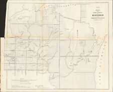 1856 Wisconsin & MN Survey Antique Map Lithograph - Ackerman NY ~ 21.5" x 18.7"
-
$39.00
 1878 Western Hemisphere Mitchell antique map 15.1" x 12.1" - nice color
-
$89.00
 1878 Boston Mitchell antique map / plan 23" x 15.1" - nice color - harbor inset
-
$13.86
 1920 Color Maps Physical New Zealand & Tasmania, Old New Testament Palestine Map
-
$240.00
 CIVIL WAR 1862-63 "Map of the Battle-Grounds in the Vicinity of Richmond, VA."
-
$32.00
 1879 Map West Central States Group Victorian Atlas Geography 1st Edition DWAA9
-
$16.00
 Map Of Original 13 Colonies 1871 Victorian Lithograph History Swinton DWAA12
-
$32.00
 1879 Map New England USA Victorian Atlas Harpers Geography 1st Edition DWAA9
-
$14.97
 Vtg 1980's Kroll's Map of Alaska Cities Towns Highways Airports 37 4/2" x 43"
-
$39.00
 1878 Oregon Washington MT ID Mitchell antique map 15.1" x 12.3" - nice color
-
$13.86
 1920 Color Maps Physical Africa and British South Africa Map
-
$149.00
 1878 Texas antique map 22.8" x 15.1" nice color - Galveston Indian Territory NM
-
$17.00
 USA - Original 1903 Physical Map by Dodd Mead & Company. Antique
-
$45.00
 1878 Kentucky & Tennessee Mitchell antique map 15.1" x 12" - nice color
-
$32.00
 1879 Map West Pacific NW & Southwest Group Victorian Geography 1st Edition DWAA9
-
$32.00
 1879 Map Texas & Southern Plains States US Victorian Geography 1st Edition DWAA9
-
$13.86
 1920 Color Maps Physical Features of Ireland and Scotland Map
-
$8.77
 Antique Map Of The Eastern United States Dated 1901 The Mississippi States
-
$75.00
 1862 Johnson Virginia PA DE MD antique map 26.6" x 18.1" nice color - Richmond
-
$125.00
 1883 General Sherman Route Map Fort Ellis Montana to Fort Hope British Columbia
-
$16.00
 Eastern USA - Original 1909 Physical Map by John Bartholomew. Antique
-
$13.86
 1920 Color Maps Political United States and Physical South America Map
-
$65.00
 1856 Louisiana Antique Survey Map - Lithograph - Duval - 18.3" x 17" - Congress
-
$55.00
 1878 North & South Carolina Mitchell antique map 15.1" x 12.3" - nice color
-
$11.24
 Vintage 1950 New Hampshire Vermont Highway Road Map Guide Cities Service Station
-
$112.91
 1925 Indexed Antique Map of Boston, Massachusetts by Walker Lithograph Co.
-
$28.57
 1898 Map of NEW BRUNSWICK and QUEBEC Hand Colored Lithograph 10.75 x 7.25
-
$24.00
 Map Territorial Growth Of United States 1871 Victorian Lithograph History DWAA12
-
$125.00
 1877 F. V. Hayden Parts of Western Wyoming and Southeastern Idaho Map
-
$55.00
 1862 Johnson Kentucky & Tennessee antique map 24.7" x 17.9" nice color
-
$45.00
 1862 Johnson's Missouri and Kansas Map Johnson & Ward Antique
-
$45.00
 1862 Johnson's New York Map Johnson & Ward Illustrated Family Atlas Antique
-
$255.00
 1860 Washington & Oregon Mitchell antique map 15.4" x 12.6" rare 1st edition
-
$100.00
 2 Maps, Big Trees, Conservation of California Sequoias, Big Tree Groves, 1900
-
$17.00
 The America's - Original 1924 German Physical Map by Meyers. Vintage
-
$285.00
 1857 UTAH MAP: Sketch of the Country between South Pass & the Great Salt Lake
-
$17.00
 The America's - Original 1928 Physical Map by Meyers. German Language Map
-
$12.99
 Vintage 1940s COLORADO Highway Road Map - Chevron RPM Gasoline Service Station
-
$44.99
 1933 Blue Hills Reservation Map Roads Paths and Trails 22" x 15" Original Print
-
$17.00
 Original Physical & Economic Map of the Americas in 1910 by Meyers. German
-
$13.86
 1920 Color Maps Physical Features Asia + North & South Polar Regions Map
-
$11.86
 1920 Color Maps Physical Indian Empire + Farther India and the East Indies Map
-
$13.86
 1920 Color Maps Physical Australasia + Oceania Map
-
$13.86
 1920 Color Maps Political England & Wales + Physical Scotland 2X pages Map
-
$74.99
 1885 ANTIQUE MAP 22.5" Eskimo Territory NORTH CANADA Nunavut First Issue VTG
-
$13.86
 1920 Color Maps Eastern Provinces of Canada and Physical North America Map
-
$275.00
 1862 Johnson Texas antique map 25.6" x 18.6" nice color - Galveston, Sabine Lake
-
$9.99
 1958 McNally Map - South Dakota - Pierre Black Hills Rapid City Mt. Rushmore
-
$59.00
 1878 New York Mitchell antique map 23" x 15.1" nice color & city insets
-
$75.00
 1849 Lithograph of 1st Printed Chart of Coast of New England & New Netherlands
-
$11.86
 1920 Color Maps Physical Features of Switzerland and the Alps Map
-
$65.00
 1862 Johnson New York with many insets antique map 26.1" x 17.8" nice color
-
$6.95
 Vintage 1962 Colorful Colorado State Highway Department Road Map Travel Guide
-
$45.00
 1862 Johnson Iowa & Nebraska antique map 17.6" x 14.2" nice color
-
$55.00
 1878 Washington DC & Baltimore Mitchell antique map 15.1" x 12.3" - nice color
-
$39.00
 1878 Virginia & West, MD DE & NJ Mitchell antique map 15.1" x 12" - nice color
-
$12.49
 VTG 1935 Where to Stay in Boson A Street Map Boston Chamber of Commerce 26 x 17
-
$49.00
 1862 Johnson state of New Jersey antique map 16.6" x 14" nice color
-
$35.00
 1856 Design for New D.C. Jail - Antique Lithograph - Duval ~ 22.2" x 18"
-
$189.00
 1860 Minnesota & Dacotah Mitchell antique map 15.5" x 12.7" rare 1st edition
-
$50.00
 Vintage 1946 Los Angeles Hollywood Tour Map - Shell Oil Service Station
-
$32.00
 1879 North Central States Group US Victorian Atlas Geography 1st Edition DWAA9
-
$16.00
 Map War Of 1812 Indian Wars 1871 Victorian Lithograph History Swinton DWAA12
-
$16.00
 Map Sherman's Army Virginia Operations 1871 Victorian Lithograph History DWAA12
-
$32.00
 1879 Map Massachusetts Boston US Victorian Atlas Geography 1st Edition DWAA9
-
$9.99
 1942 Pecos River Basin Texas New Mexico - Percipitation Distribution Map Roswell
-
$75.00
 1860 US Canada Mexico C. America Mitchell antique map 15.3" x 12.5" hand color
-
$16.00
 1879 Map Rhode Island United States Victorian Geography 1st Edition DWAA9
-
$55.00
 1860 Maine Mitchell antique map 15.1" x 12.5" vibrant hand color Portland Harbor
-
$49.00
 1862 Johnson Maryland Delaware DC & insets antique map 17.5" x 14.1" nice color
-
$99.99
 Rare Original 1891 Antique Map Texas Oklahoma Indian Territory Matthews-Northrup
-
$32.00
 1879 Map United States Physical Groups Victorian Geography 1st Edition DWAA9
-
$65.00
 Large 1896 Map of El Paso, Showing 'Smelter' Area, Mexican-American Dam
-
$40.00
 1856 Arkansas Survey Antique Map - Lithograph - Ackerman Broadway NY 18" x 17.3"
-
$32.00
 1879 Map US Mid Atlantic States Victorian Harpers Geography 1st Edition DWAA9
-
$275.00
 MATTHEWS c1856 Map Of Upper Canada Ontario Indian Land Agency Divisions Scarce!


