 Antiques (US)
-
$32.31

 Saxton's Map Northamptonshire, Bedfordshire,Cambridge,Rutland 1576 Lithograph
-
$18.63
 1898 Lincolnshire, Rutland & Leicestershire large map. 125 years old. Grantham.
-
$17.97
 1895 Leicester & Rutland map. 128 yr old Victorian print. Loughborough, Oakham.
-
$17.97
 1882 Leicestershire & Rutland antique map. England. Melton Mowbray, Oakham.
-
$12.45
 1875 Antique Map; Rutlandshire by Teesdale / Heywood
-
$17.97
 1904 Leicestershire & Rutland old map. Large size. 119 yrs old. Leicester Oakham
-
$16.35
 1895 Leicestershire & Rutland county map. Victorian. Melton Mowbray, Oakham.
-
$32.40
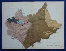 Original antique GEOLOGICAL MAP, LEICESTERSHIRE, RUTLANDSHIRE, Reynolds, 1864-89
-
$15.74
 1908 antique Lincolnshire road map. Grantham, Spalding. Part Cambridgeshire.
-
$18.69
 Antique map of Rutland by Samuel Lewis 1834
-
$16.69
 1894 Leicestershire, Rutland, Huntingdon and Northamptonshire Victorian map.
-
$22.43
 LEICESTERSHIRE, RUTLAND, LEICESTER, STAMFORD, original antique map, Bacon, 1895
-
$22.43
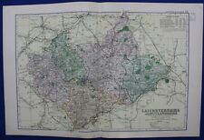
 LEICESTERSHIRE, RUTLANDSHIRE, original antique Victorian county map, Bacon, 1890
-
$18.68
 1804 (1858) Antique Map: Rutlandshire by Cole from Railway & Pedestrian Atlas


