 Antiques (US)
-
$39.96

 Geological Map Of The British Islands 4th Edition Sir William Pugh 32” x 25”
-
$37.88
 OLD 1853 ENGLAND IRELAND Map ORIGINAL Wales Scotland London Dublin Glasgow
-
$37.88
 1855 Great Britain Map ORIGINAL England Ireland Scotland Wales London Dublin
-
$47.88
 1898 British Islands ENGALND Map Anglo-Saxon and Celtic Kingdom Ireland Scotland
-
$11.20
 1937 McNally Map British Isles Great Britain & Ireland England Scotland London
-
$37.00
 1890 Saxon Medieval England Scotland Map London Hadrian's Wall Picts Shetland
-
$75.00
 1876 British Isles antique map ~ 27.5" x 19.6" hand colored - Scotland & Ireland
-
$12.00
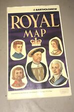 John Bartholomew Royal Map of England United Kingdom Scotland Kings and Queens
-
$65.00
 Vintage Lot of British Decor London Map, England/Scotland Road Atlas, Art Prints
-
$51.99
 1818 D'Anville Map British Isles Roman Period Londinium Hadrians Wall England
-
$31.99
 1839 Boynton Map - British Islands England Scotland Wales Ireland London Dublin
-
$9.99
 1888 Mitchell Map Europe France Germany Austria Hungary Italy Greece Sweden
-
$19.99
 1857 Findlay Map - Insulae Britannicae - England Scotland Ireland London Roman
-
$29.53
 British Isles Britain geological palaeontological fossil map 1848 print poster
-
$29.53
 old antique Victorian Geological map British Isles Ramsay 1878 art print poster
-
$24.91
 1899 Great Britain & Ireland Original Antique Map by Richard Andree
-
$19.99
 1921 Johnston Map Netherlands Belgium Luxemburg Holland Amsterdam Brussels Ghent
-
$11.99
 1849 Bilder Atlas Map - Great Britain & Ireland - England Wales Scotland London
-
$31.99
 c.1848 Glaser Atlas Map Great Britain & Ireland - England Wales Scotland London
-
$31.99
 1812 Malte Brun Lapie Map - England Wales London Oxford Liverpool Great Britain
-
$23.99
 1846 Bocage & Vuillemin Map British Isles England Wales Scotland Ireland London
-
$19.99
 1880 Migeon Map - British Isles - England Wales Scotland London Great Britain UK
-
$28.00
 1877 Migeon Map - British Isles Great Britain England Scotland Ireland London UK
-
$19.99
 1875 Petermann Map - North Sea - Great Britain England Ireland Scotland London
-
$19.99
 1881 Andrees Map Great Britain England Scotland Ireland London British Isles UK
-
$19.99
 1887 Andrees Map - England Wales - London Liverpool Nottingham Bristol Thames UK
-
$15.99
 1863 Cornell Map - British Isles England Wales Scotland Ireland London Dublin UK
-
$19.99
 1849 Houze Map Great Britain 1281-1400 England Ireland Scotland London Edward
-
$99.00
 1812 Lapie Map of Great Britian Scotland and Ireland
-
$42.50
 British Isles England Wales Scotland Ireland London Dublin 1842 Tardieu map
-
$29.53
 UK British Isles Great Britain geological map Best & Stanford 1893 print poster
-
$47.50
 England U.K. Wales Scotland Cornwall Derby London Suffolk c.1840 map 2 SHEETS
-
$19.99
 1921 Johnston Physical Map British Isles Great Britain England Ireland Scotland
-
$23.99
 1880 Spruner Map - British Isles 12 Century to the Reformation - England Ireland
-
$9.99
 1835 Levasseur Map - British Isles - Great Britain & Ireland - England Scotland
-
$19.99
 1849 Houze Map Great Britain 1603-1849 England Ireland Scotland London Dublin
-
$15.99
 1875 Lange Physical Map - British Isles - England Wales Scotland Ireland London
-
$19.99
 1835 Monin Fremin Map - Great Britain & Ireland - England Scotland Wales London
-
$14.99
 A Travelers Map Of The British Isles Nat Geo 1974 Antique
-
$180.00
 1785 Johann Probst Map Great Britain England Scotland Wales Ireland London UK
-
$19.99
 1832 Murphy Map Britannia Antiqua Britain England Wales Roman Londinum London UK
-
$27.75
 Vintage Color Map ~ BRITISH ISLES ~ ENGLAND IRELAND SCOTLAND WALES Printed 1883
-
$19.99
 1849 Houze Map Great Britain 1100-1280 England Ireland Scotland Isle Man London
-
$9.99
 1880 Labberton Map British Islands Saxon Period England Ireland Scotland Scotia
-
$9.99
 1892 Map British Isles Industry Iron Minerals Agriculture Commerce Iron England
-
$5.99
 Vintage 1943 Atlas Map World War WWII Era England, Wales & Scotland London Inset
-
$23.99
 1880 Spruner Map - British Isles 1485-1830 - England Scotland Wales Ireland UK
-
$80.00
 1839 Allan Bell Atlas Map - British Isles Great Britain Ireland Scotland England
-
$19.99
 1875 Lange Map - British Isles - England Wales Scotland Ireland London Dublin UK
-
$31.99
 1844 Smith Map British Isles Great Britain England Scotland Ireland London Wales
-
$25.00
 1901 Tunison Europe & South America antique map ~ 22.8" x 14.6" nice color
-
$47.99
 1847 Stieler Map British Isles England Scotland Ireland London United Kingdom UK
-
$39.99
 1810 Delalain Map British Isles Great Britain England Wales Scotland Ireland
-
$33.97
 1888 ANTIQUE MAP LONDON TUBE RAILWAYS ENGLAND DUBLIN IRELAND EDINBURGH SCOTLAND
-
$31.99
 1800 Wilkinson Map Ancient Britannica England Scotland Ireland Wales Roman Era
-
$12.45
 19thC Trade Card Map Great Britain WRONG! Newcastle in Scotland Scottish Postman
-
$25.00
 1901 Tunison England Ireland Scotland antique map ~ 23" x 14.6" nice color
-
$28.30
 1912 ANTIQUE MAP OF NORTHERN SCOTLAND HIGHLANDS ORKNEY / VERSO ABERDEEN DUNDEE
-
$27.42
 Job lot of 7 vintage Ordinance Survey Maps, 1956-78, London, Scotland, Ashington
-
$18.94
 1908 ANTIQUE MAP CITY MAP OF LONDON ENGLAND / EDINBURGH SCOTLAND DUBLIN IRELAND
-
$45.00
 18th century Stirling and Clackamannan Counties in Scotland Antique Map
-
$18.00
 CA 1935 VINTAGE MAP OF GREAT BRITAIN ENGLAND WALES SCOTLAND IRELAND
-
$12.45
 c1900 Post Card Map Great Britain Patriotic Imperial Boy Flag Ship Hunt London
-
$31.43
 1955 VINTAGE MAP OF UNITED KINGDOM GREAT BRITAIN ENGLAND / SCALE 1:2,500,000
-
$45.05
 British Isles Atlas map by J Migeon coloured engraved vignettes 1884
-
$18.00
 1943 VINTAGE WWII MAP OF GREAT BRITAIN UNITED KINGDOM SCOTLAND IRELAND
-
$35.10
 1904 ANTIQUE MAP OF LONDON DOWNTOWN / ENGLAND / VERSO EDINBURGH DUBLIN IRELAND
-
$10.95
 Antique 1880 Ireland-England-Scotland book plate Map 9 x 12-suitable to frame
-
$19.00
 1889 Antique Great Britain 9 Maps Plates Encyclopedia York Saxony Kent Wilshire
-
$99.00
 1840 British Isles map by Greenleaf 14.2" x 11.9" scarce 1st edition antique
-
$120.00
 1812 Darton Union Atlas Map United Kingdom England Scotland Ireland London UK
-
$218.08
 BRITISH ISLES, Roman Britain, Edward Wells, original antique map c1720
-
$195.00
 1780 Kingdoms of England Scotland & Ireland antique map by Bonne/Lattre - framed
-
$61.06
 VINTAGE ADMIRALTY CHART. No.2176. NORTH FORELAND to DUNCANSBY HEAD . 1940 EdN.
-
$18.68
 1889 Arbuckle Great Britain London Antique Print Trade Card Big Ben Royal Navy
-
$157.64
 1887 ANTIQUE MAP BRITISH ISLES SCOTLAND ENGLAND IRELAND LONDON EDINBURGH DUBLIN
-
$218.08
 1572 Porcacchi Great Britain Scotland England Wales Ireland Framed No London!
-
$118.38
 c1860 Brockhaus Illustrated Map Great Britain England Scotland Wales Ireland UK
-
$14.00
 1882 ANTIQUE GUYOT COLOR MAP ~ BRITISH ISLES ~ ORIGINAL & EXTREMELY RARE
-
$7.46
 Vintag Geographia Route Guide 100 MILES ROUND LONDON Atlas, Index & Fold Out Map
-
$195.00
 Vintage c.1773 MAP OF SCOTLAND & HEBRIDES Old Antique Original PUBLISHED c.1830
-
$600.00
 1743 MAP OF EUROPA CONTINENT HOMANN HEIRS ORIGINAL COLORED COPPERPLATE
-
$10.16
 Aberdeen Streetfinder Map by Collectif Sheet map, folded Book The Fast Free
-
$57.49
 1823 ORIGINAL MAP IRELAND UNITED KINGDOM ENGLAND WALES SCOTLAND DUBLIN LONDON
-
$14.95
 1920s Geographia Route Guide 100 MILES ROUND LONDON Atlas, Index & Fold Out Map
-
$35.00
 1856 ORIGINAL MAP UNITED KINGDOM GREAT BRITAIN IRELAND ENGLAND SCOTLAND WALES
-
$3.73
 1920s Geographia Route Guide 100 MILES ROUND MANCHESTER Atlas, Index & Fold Map
-
$1237.50
 1560 Sebastian Munster Antique Map of England Wales Parts Scotland, Ireland, 1st
-
$8.72
 London Theatres Cinemas 1955 Original vintage map wall art picture display
-
$3.10
 1920s Geographia Route Guide 100 MILES ROUND LONDON Atlas, Index & Fold Out Map
-
$12.45
 Original antique MAP, 1834. British Isles by Felix Delamarche.
-
$39.00
 Fine Antique Russell Map - SCOTLAND BEST AUTHORITIES - Copper Engraving - 1818


