 Antiques (US)
-
$13.00

 1943 Vintage Map - Indian Land Cessions 1784-1798 - Kentucky - Ohio - Tennessee
-
$49.99
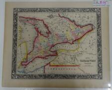 S. Augustus Mitchell Hand Colored 1860 Canada West Counties Great Lakes Map B14
-
$13.00
 1943 Vintage Map - Ohio Country 1787-1803 - Michigan - Detroit - Cleveland
-
$6.85
 1956 Antique OHIO Atlas Map Vintage Hammond's Family Reference World Atlas
-
$24.99
 1880 Antique Atlas Map / OHIO, MICHIGAN, INDIANA, KENTUCKY
-
$9.99
 1908 Rand McNally Map - Ohio - Cleveland Columbus Cincinnati Toledo Sandusky
-
$11.99
 1884 McNally Map Ohio Columbus Cleveland Cincinnati Toledo Dayton Youngstown
-
$15.99
 1885 McNally Map - Ohio - Cleveland Cincinnatti Columbus Youngstown Toledo - OH
-
$24.99
 1885 Antique Atlas Map / OHIO, MICHIGAN, ILLINOIS, INDIANA, WISCONSIN
-
$32.50
 1889 Rand McNally Map of Cleveland, Ohio (14.5" x 22")
-
$9.99
 1917 McNally Map - Ohio - Columbus Cleveland Cincinnati Toledo Dayton Youngstown
-
$7.99
 1882 Antique Map Illinois Indiana Ohio Kentucky Central USA approx 11"x8.5"
-
$48.88
 1875 KENTUCKY TENNESSEE Map ORIGINAL OHIO WEST VIRGINIA INDIANA Maryland
-
$5.78
 1957 Vintage OHIO Atlas Map Old Authentic Antique MCM Encyclopedia Britannica
-
$6.10
 1915 Antique OHIO Miniature Atlas Map (8" x 5.5") Hammond's Handy Atlas
-
$6.32
 1960's Vintage OHIO Atlas Map - Old Antique Rand McNally World Atlas
-
$19.99
 c 1900 George Cram Map Ohio Columbus Cleveland Cincinnati Youngstown Toledo OH
-
$24.99
 1870 Clarke County Ohio Atlas Map / UNITED STATES OF AMERICA / 16x26 inches
-
$9.99
 1927 Hammond Map - Ohio - Columbus Cleveland Cincinnati Toledo Dayton Youngstown
-
$19.99
 1872 Asher & Adams Map - Ohio Indiana Cleveland Indianapolis Cincinnati Chicago
-
$11.99
 1911 McNally Map - Ohio Cleveland Cincinnati Columbus Youngstown Toledo AKron
-
$19.95
 CENTURY ATLAS MAP PLATE #18 OHIO SOUTHERN CINCINNATI CLEVELAND 1911 ANTIQUE ORIG
-
$24.99
 1875 Antique COLOR Gray’s Atlas Map / OHIO
-
$34.99
 Original 1874 Stewart & Page Map BERLIN HEIGHTS Erie County Ohio Property Owners
-
$134.99
 Map FRONTIERS OF THE NORTHERN COLONIES + 1768 Fort Stanwix Treaty with Indians
-
$19.99
 c 1900 Cram Index Map Ohio Columbus Cleveland Cincinnati Youngstown Toledo OH
-
$19.99
 1902 Century Atlas Map x 2 - Ohio - Cincinnati Cleveland Columbus Toledo Akron
-
$15.99
 1911 McNally Index Map - Ohio Columbus Cleveland Cincinnati Akron Dayton Canton
-
$5.35
 1912 Vintage CINCINNATI Atlas Map Original Antique Rand McNally Imperial Atlas
-
$5.08
 1954 Vintage OHIO Antique Atlas Map - Encyclopedia Britannica World Atlas
-
$13.00
 Antique 1800s Hand Colored Map of the Nine Central States Cowperthwait 12.75 x10
-
$4.50
 1952 Vintage OHIO Antique Atlas Map - Encyclopedia Britannica World Atlas
-
$19.99
 c 1900 Cram Map Ohio Columbus Cleveland Cincinnati Youngstown Dayton Antique
-
$19.99
 1869 Antique Mitchell COLOR Map / OHIO, KENTUCKY, INDIANA, ILLINOIS, IOWA
-
$5.00
 1892 Popular Atlas of the World Map of Ohio and Illinois
-
$31.99
 1864 Johnson Map - Ohio & Indiana Columbus Capitol Cleveland Indianapolis OH IN
-
$19.95
 CENTURY ATLAS MAP PLATE #17 OHIO NORTHERN TOLEDO CLEVELAND OH 1911 ANTIQUE ORIG
-
$8.95
 Antique Color Map 1913 State of Ohio or Indiana
-
$8.10
 1902 state map of Ohio Northern Part antique vintage Britannica 10th
-
$8.10
 1902 state map of Ohio Southern Part antique vintage Britannica 10th
-
$9.99
 CENTURY ATLAS MAP PAGE PLATE NO.17 OHIO NORTHERN PART 1911 VINTAGE
-
$34.99
 1883 Antique Map / STATE OF OHIO, Size about 25x25.5"
-
$32.50
 1889 Rand McNally Map of Toledo, Ohio (14.5" x 22")
-
$34.99
 Original 1875 Everts Map PATASKALA Columbia Center Lima Twp Licking County Ohio
-
$9.99
 1898 Century Atlas Map - Southern Ohio - Cincinnati Columbus - Cleveland Plan
-
$18.99
 1877 Antique Eclectic COLOR Map / NORTH CENTRAL STATES
-
$27.99
 1907 Map United States New York Jersey Pennsylvania Massachusetts Maine Vermont
-
$19.99
 1900 Meyers Map Northeast United States New York Virginia Ohio Michigan Maine
-
$24.99
 1875 Perry County Ohio Atlas Map / UNITED STATES OF AMERICA / 16x26 inches
-
$16.00
 1896 Mathews Northrup Map Illinois Kentucky Indiana Ohio Chicago Cincinnati
-
$7.99
 CENTURY ATLAS MAP PAGE PLATE NO.18 OHIO SOUTHERN PART 1911 VINTAGE
-
$39.99
 1869 Chambers Map East United States New York Florida Virginia Missouri Michigan
-
$13.99
 1893 Ohio State Map Gaskell's Family & Business antique City of Cincinnati verso
-
$24.99
 1870 Clermont County Ohio Atlas Map / UNITED STATES OF AMERICA / 16x26”
-
$24.99
 Original 1875 Everts Twp Maps MARY ANN + PERRY Ghost Towns Licking County Ohio
-
$19.99
 Original 1897 Map Southern OHIO Marietta Dayton Cincinnati Columbus + Cleveland
-
$27.99
 1898 RARE ORIGINAL MAP UNITED STATES TEXAS FLORIDA NEW YORK CALIFORNIA ILLINOIS
-
$7.49
 CRAM'S ATLAS MAP PAGE PENNSYLVANIA OHIO MARYLAND 1899 VINTAGE
-
$19.99
 1906 Johnston Royal Atlas Map - NE United States New York Virginia Massachusetts
-
$8.49
 CRAM'S ATLAS MAP PAGE OF VIRGINIA WEST VIRGINIA OHIO DELAWARE MARYLAND 1890
-
$12.95
 Detroit Michigan or Toledo Ohio Antique Map 1892 Cram
-
$51.99
 1870 Asher Adams Map Illinois Indiana Ohio Missouri Tennessee Kentucky Chicago
-
$49.99
 1870 CLERMONT County Ohio Atlas Map / TOWNSHIP MAP OF OHIO / 24x24 inches
-
$24.99
 Original 1875 Everts Map BENNINGTON TOWNSHIP Appleton Licking County Ohio Kiln
-
$53.75
 Vintage Rare 1909 OHIO MAP - CONGRESSIONAL DISTRICTS - RAILROADS - ELECTRIC LINE
-
$49.99
 1862 ORIGINAL MAP UNITED STATES TEXAS LOUISIANA ILLINOIS OHIO INDIANA MICHIGAN
-
$27.99
 1898 RARE ORIGINAL MAP UNITED STATES OREGON FLORIDA NEW YORK CALIFORNIA ILLINOIS
-
$18.68
 Encyclopaedia Britannica Map 1903 Ohio Northern Part United States
-
$49.99
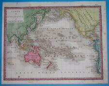 1844 RARE ORIGINAL MAP PACIFIC UNITED STATES CANADA AUSTRALIA HAWAII GUAM ASIA
-
$18.68
 Encyclopaedia Britannica Map 1903 Ohio Southern Part United States
-
$28.00
 1898 ORIGINAL MAP UNITED STATES TEXAS NEW YORK CALIFORNIA FLORIDA UTAH OHIO CUBA
-
$59.99
 1856 NICE ORIGINAL MAP UNITED STATES CANADA TEXAS CALIFORNIA MEXICO NEW YORK


