 Antiques (US)
-
$200.00

 1867 Kansas Colorado Montana & Dacota Hand Colored Map 13 x 15 Mitchell Antique
-
$300.00
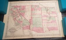 1867 Johnson's California, with Utah, Nevada, Colorado, New Mexico and Arizona
-
$350.00
 1864 Johnson's California with territories of Utah, Nevada, Colorado, New Mexico
-
$19.95
 1676 hand colored map of Virginia and Maryland COPY on hi quality photo paper
-
$199.00
 Rare 1934 De Soto Expedition Route Map Swanton Artifact Antique Native American
-
$200.00
 "A Map of Long Island" NY Historic Wall Map Wall Art Decorative Wood Piece
-
$25.95
 Antique Framed - EUROPE PICKWICK MIDY Map 230 years old!! 13x16 oak
-
$21.95
 COPY 1863 Lloyds Military Map Border & Southern States territory held by Rebels
-
$95.00
 Antique 1892 North Pole Unknown Region Map Excellent Large Wall Size 15 1/2 x 22
-
$648.00
 Antique Map of Hawaiian Islands Hawaii Trade with the US 1896 Imports Exports
-
$8.77
 Old Antique Picture Poster wall map North, South America: 1720 1700's Reprint
-
$7.52
 Old Antique poster picture map of New Jersey, New York USA 1674 1600's Reprint
-
$26.95
 Antique Framed - ASIA PICKWICK MIDY Map 230 years old!! 13x16 oak
-
$150.00
 LONG ISLAND, NEW JERSEY, HUDSON RIVER: U.S. COASTAL SURVEY, 1854
-
$100.00
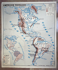
 AMERICA CLIMATE & RELIEF c. 1950 LARGE PHYSICAL WALL MAP
-
$9.99
 Vintage 1977 United States Map Poster Scholastic 31 x 21” Collect or Student Use
-
$100.00
 AMERICA c. 1950 LARGE PHYSICAL WALL MAP


