 Antiques (US)
-
$62.61

 1747 Roman Britain Original Antique Map by Richard Seale
-
$25.03
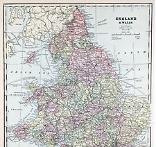
 1853 England & Wales Antique Map with Ornate Border by Alexander Findlay
-
$25.03
 1885 British Isles & North Sea Antique Map by John Bartholomew & George Philip
-
$25.03
 1863 North West England & Wales, Isle Of Man Hand Coloured Weekly Dispatch Map
-
$21.00
 1843 Europe Map Prussia Germany Iceland Ireland POLITICAL Russia Moscow Austria
-
$24.00
 1853 British Isles Map ORIGINAL England Wales Scotland Ireland London Dublin
-
$37.00
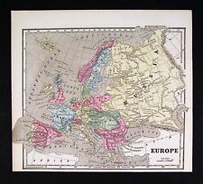
 1853 Europe Map ORIGINAL Turkey Russia Prussia Iceland Sardinia England Sweden
-
$8.14
 1902 Map of England and Wales Northern Part antique vintage Britannica 10th
-
$19.99
 1869 Antique Mitchell COLOR Map / GREAT BRITAIN AND IRELAND
-
$38.00
 ENGLAND WALES Map 1889 ORIGINAL London Dover Railways Counties Townships G. CRAM
-
$24.99
 1880 Antique Atlas Map / GREAT BRITAIN AND IRELAND
-
$9.99
 1892 Crowell Kirkpatrick Map - England & Wales London Liverpool Bristol Cornwall
-
$281.73
 BRITISH ISLES Britain, Frederick De Wit original antique map circa 1675
-
$25.03
 1882 England & Wales Hand Coloured Antique Map from Stanford's London Atlas
-
$31.29
 1860 South England & Wales Hand Coloured Antique Map by G.W. Blackie
-
$25.03
 1879 North England & Wales Large Original Antique Map by John Bartholomew
-
$331.82
 BRITISH ISLES, Great Britain, UK, Nicolas De Fer original antique map 1706
-
$27.99
 1838 Gilbert Antique Map England & Wales London Liverpool Oxford Great Britain
-
$106.43
 ENGLAND, Anglia Cambdeni, Christoph Weigel, Weigelio, original antique map 1718
-
$9.99
 1888 Mitchell Map Europe France Germany Austria Hungary Italy Greece Sweden
-
$31.30
 GUILDFORD, SURREY Town & Street Plan, Dawson Original antique map 1832
-
$8.49
 CRAM'S ATLAS MAP PAGES OF EUROPE - ENGLAND & WALES 1890 VINTAGE
-
$11.99
 1900 Meyers Map England Wales London Liverpool Oxford Newcastle Great Britain
-
$62.54
 1719 LARGE ANTIQUE MAP ENGLAND - NOUVELLE CARTE DE L'ANGLETERRE - CHATELAIN
-
$16.00
 1867 Mitchell Map - Europe - Austria Italy Germany France Britain Spain Iceland
-
$9.99
 1902 Century Map - South England Wales London Plan Stonehenge Cornwall Bristol
-
$24.99
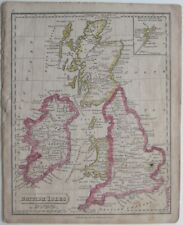 Original 1821 Map BRITISH ISLES England Scotland Ireland Wales Printed in Boston
-
$19.99
 1830 Nathan Hale Map - England & Wales - London Liverpool Cornwall Dover Bristol
-
$25.03
 1840 England & Wales Original Antique Hand Coloured Map by Sidney Hall
-
$25.03
 1891 SOUTHERN ENGLAND & WALES LARGE COLOUR MAP BY W.G. BLACKIE
-
$25.03
 1854 NORTHERN ENGLAND & WALES LARGE HAND COLOURED ANTIQUE MAP 165 YEARS OLD
-
$31.29
 1860 British Isles Hand Coloured Antique Map by G.W. Blackie
-
$39.99
 1810 Delalain Map British Isles Great Britain England Wales Scotland Ireland
-
$8.14
 1902 Map of England and Wales Southern Part antique vintage Britannica 10th
-
$15.99
 1882 Cowperthwait Map Great Britain Ireland Scotland England Wales London Dublin
-
$23.99
 1846 Bocage & Vuillemin Map British Isles England Wales Scotland Ireland London
-
$31.99
 1812 Malte Brun Lapie Map - England Wales London Oxford Liverpool Great Britain
-
$106.43
 BRITISH ISLES, Great Britain, UK, Schreiber original antique map c1730
-
$25.03
 1882 North England & Wales Original Antique Colour Map by Edward Weller
-
$25.03
 1894 Large Map of England & Wales by Edward Stanford 75 cm x 56 cm
-
$9.99
 1883 Johnston Map - North England & Wales Liverpool York Lincoln Isle of Man UK
-
$15.99
 c. 1840 Ewing Antique Map England & Wales London Liverpool Oxford Great Britain
-
$9.99
 1853 Morse Map - Europe Austria France Germany Italy Spain Russia Great Britain
-
$56.35
 1809 LARGE ANTIQUE COPPER PLATE MAP ENGLAND & WALES - STOCKDALE / CARY
-
$19.99
 1876 Bartholomew Map - England & Wales - London Liverpool Bristol Cornwall Dover
-
$27.99
 1847 Flemming Map England Wales London Cornwall Bristol Liverpool Manchester UK
-
$9.99
 1917 McNally Map - England Wales London Liverpool Manchester Bristol Cardiff UK
-
$80.00
 1839 Allan Bell Atlas Map - British Isles Great Britain Ireland Scotland England
-
$15.99
 1863 Cornell Map - British Isles England Wales Scotland Ireland London Dublin UK
-
$39.99
 1845 Stieler Map England Wales London Liverpool Canterbury Cardiff Manchester UK
-
$17.99
 1914 Antique COLOR Map / ENGLAND AND WALES
-
$9.99
 1880 Petermann Map England Wales Great Britain London Liverpool Oxford Lands End
-
$19.99
 1880 Migeon Map - British Isles - England Wales Scotland London Great Britain UK
-
$15.99
 1857 Morse Map - England - London Liverpool Oxford Bristol Cornwall Canterbury
-
$15.99
 1857 Morse x 2 England Map & Print of Birmingham View - London Liverpool Oxford
-
$9.99
 1835 Levasseur Map - British Isles - Great Britain & Ireland - England Scotland
-
$15.99
 1900 Times Map England Wales London English Channel Middlesex Bristol Oxford UK
-
$9.99
 c1925 Taschen Atlas Map British Isles England Scotland Ireland London Dublin UK
-
$31.99
 1834 Carey Map British Isles England Wales Scotland Ireland London Britain UK
-
$31.99
 1844 Smith Map British Isles Great Britain England Scotland Ireland London Wales
-
$9.89
 CENTURY ATLAS MAP PAGE PLATE NO.76 ENGLAND AND WALES NORTHERN PART 1911 VINTAGE
-
$19.99
 1887 Bradley Map - England & Wales - London Cardiff Liverpool Great Britain UK
-
$23.99
 1886 Tunison Map England Wales London Salisbury Liverpool Bristol Cardiff Thames
-
$47.99
 1796 Blondeau Map England Wales London Bristol Oxford Salisbury Manchester
-
$9.99
 1898 Century Atlas Map South England Wales London Plan Stonehinge Battlefields
-
$28.00
 1830 Nathan Hale Map England Wales London Liverpool Oxford Cornwall Bristol UK
-
$27.55
 TENBY, WALES, Town & Street Plan, Dawson Original antique map 1832
-
$47.99
 1847 Stieler Map British Isles England Scotland Ireland London United Kingdom UK
-
$93.91
 BRITISH ISLES BRITAIN UK Insulae Albion et Hibernia John Seller Antique Map 1694
-
$5.73
 1915 Antique BRITISH ISLES Miniature Atlas Map (8" x 5.5") Hammond's Handy Atlas
-
$27.99
 1885 Stanford Map England & Wales London Liverpool Bristol Oxford Antique
-
$9.89
 CENTURY ATLAS MAP PAGE PLATE NO.75 ENGLAND AND WALES SOUTHERN PART 1911 VINTAGE
-
$31.99
 1830 Nathan Hale Map England & Wales London Bristol Oxford Salisbury Manchester
-
$9.99
 Original 1884 Bartholomew Map ENGLAND & WALES Railways Cornwall York Irish Sea
-
$29.99
 Original 1824 Macpherson Engraved Map BRITANNIA ROMANA HIBERNIA Thule Insula
-
$24.99
 Original 1834 Map ENGLAND & WALES Yorkshire Devon Oxford London Liverpool Exeter
-
$25.03
 1902 The British Isles Antique Map by G.W. Bacon over 120 Years Old
-
$8.49
 GASKELL'S ATLAS MAP PAGES OF EUROPE - ENGLAND/WALES - ROMAN EMPIRE 1888
-
$72.62
 ENGLAND & WALES, UK, BRITAIN, Brion de Tour original antique map c1780
-
$25.03
 1884 South England & Wales Hand Coloured Original Antique Map by Johnston
-
$49.99
 Original Color 1824 Tanner Map BRITISH EMPIRE England Wales Ireland Scotland
-
$31.99
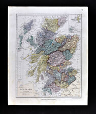 1885 Stanford Map Scotland Edinburgh Glasgow Inverness Loch Ness Arran Antique
-
$28.00
 1882 Blackie Atlas Map x 2 - England & Wales North & South - London Liverpool
-
$11.99
 1883 Johnston Royal Atlas Map North England & Wales Liverpool York Lincoln Man
-
$56.35
 NORTHERN ENGLAND, UK, BRITAIN, Rigobert Bonne, original antique map 1780
-
$52.49
 1823 ORIGINAL MAP UNITED KINGDOM ENGLAND WALES LONDON CAMBRIDGE LANCASTER YORK
-
$14.99
 Original 1887 William Bradley Map ENGLAND & WALES Canals Railroads County Towns
-
$12.46
 1810 ANTIQUE MINIATURE COPPER PLATE MAP ENGLAND & WALES - WALLIS - HAND COLOURED
-
$29.99
 Original 1890 Antique Map ENGLAND & WALES Engraved by Adam & Charles Black
-
$17.76
 1919 Vintage Map England and Wales Color Original From Collier Atlas
-
$25.03
 1902 England & Wales Antique Map by G.W. Bacon over 120 Years Old
-
$19.99
 1906 Johnston Map South England & Wales London Thames English Channel Islands UK
-
$25.03
 1850 Milford Haven Chart Original Antique Map by G.H. Swanston
-
$25.03
 1885 North East Wales Original Hand Coloured Antique Map by G.W. Bacon
-
$244.17
 BRITISH ISLES Britain Anglia Scotia Hibernia, Mercator Hondius antique map 1607
-
$25.03
 1884 North England & Wales Hand Coloured Original Antique Map by Johnston
-
$19.99
 1882 Antique COLOR Map / BRITISH ISLES
-
$25.03
 1863 Carnarvonshire & Anglesey Wales Antique Hand Coloured Weekly Dispatch Map
-
$25.03
 1899 South England & Wales Original Antique Map by Richard Andree
-
$31.29
 1854 South England & Wales Hand Coloured Original Antique Map by Selina Hall


