 Antiques (US)
-
$135.92

 1934 ATLAS BOOK Full of MAPS German Vintage B8
-
$159.00
 USA , World Atlas by Rand McNally, 1936
-
$21.19
 Northern England 1930 Original Antique Map
-
$18.73
 1931 large george philip coloured map . france - south
-
$12.99
 1935 IRISH FREE STATE, NORTHERN IRELAND & DENMARK, ICELAND - 2-Sided Color Map
-
$23.72
 World War 2 Europe Battle of the Atlantic 1939-43 Axis Expansion limits 1959 map
-
$12.99
 1935 GERMANY, SPAIN & PORTUGAL - 2-Sided Map 11" X 14"
-
$12.99
 1935 NETHERLANDS, BELGIUM, LUXEMBOURG & FRANCE - 2-Sided Map 11" X 14"
-
$12.99
 1935 NORWAY, SWEDEN & CENTRAL EUROPE - 2-Sided Map 11" X 14"
-
$13.73
 BORDEAUX WINE MAP: Carte du Blayais et du Bourgeais;1939
-
$12.99
 1935 SCOTLAND, ENGLAND & WALES - 2-Sided Color Map
-
$18.73
 Europe 1933. Russia Germany Austria-Hungary World War 1 territory loss 1959 map
-
$22.47
 Germany Poland Czechoslovakia. Central Europe. Pre-1939 borders. TIMES 1955 map
-
$90.00
 Map of Europe 1930 Antique Hachette Delaune Atlas Universel
-
$18.72
 Vintage Antique 1939 Philips Map 20x15 France South Algeria Tunis Morocco
-
$18.72
 Vintage Antique 1939 Philips Map 20x15 Spain & Portugal Madrid Lisbon Gibraltar
-
$80.00
 1935 VERDIN’S ATLAS DENMARK TOPOGRAPHICAL & PHYSICAL DOUBLE PAGE TIPPED IN MAPS
-
$42.44
 SOLWAY & BORDERS MAP, PLATE 75 BARTHOLOMEW'S SURVEY ATLAS OF ENGLAND WALES 1939
-
$45.57
 NEWCASTLE MORPETH MAP PLATE 76 BARTHOLOMEW'S SURVEY ATLAS OF ENGLAND WALES 1939
-
$21.23
 World War 2. Poland Campaign. 1-5 September 1939 German breakthrough 1959 map
-
$18.72
 Vintage Antique 1939 Philips Map 20x15 Republic of Ireland South Southern Eire
-
$42.44
 CANTERBURY MAP PLATE 28 BARTHOLOMEW'S SURVEY ATLAS OF ENGLAND WALES 1939 Kent
-
$24.96
 Vintage Antique 1939 Philips Map 20x15 Europe Communications
-
$39.94
 NEWCASTLE SHEFFIELD BIRMINGHAM LEEDS BARTHOLOMEW'S SURVEY ATLAS OF ENGLAND 1939
-
$37.44
 MILFORD HAVEN MAP, PLATE 29, BARTHOLOMEW'S SURVEY ATLAS OF ENGLAND & WALES 1939
-
$41.19
 LIVERPOOL & MANCHESTER MAP BARTHOLOMEW'S SURVEY ATLAS OF ENGLAND & WALES 1939
-
$18.72
 Vintage Antique 1939 Philips Map 20x15 Holland Amsterdam Denmark Iceland Faroe I
-
$45.57
 ALDERSHOT MAP, PLATE 26, BARTHOLOMEW'S SURVEY ATLAS OF ENGLAND WALES 1939 Hants
-
$18.72
 Vintage Antique 1939 Philips Map 20x15 Belgium Luxembourg France Low countries
-
$24.96
 Vintage Antique 1939 Philips Map 20x15 England West & Wales Liverpool Bristol
-
$24.96
 Vintage Antique 1939 Philips Map 20x15 Atlantic Ocean Communications
-
$24.96
 Vintage Antique 1939 Philips Map 20x15 Ireland RAILWAYS & Political
-
$21.23
 World War 2. Poland Campaign. 15-28 September 1939. Annihilation 1959 old map
-
$24.96
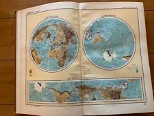
 Vintage Antique 1939 Philips Map 20x15 World Climate Vegetation & Population
-
$42.44
 CHATHAM & TONBRIDGE MAP - BARTHOLOMEW'S SURVEY ATLAS OF ENGLAND WALES 1939 Kent
-
$21.23
 World War 2. Poland Campaign 1939. Terrain Communications Industry 1959 map
-
$41.83
 NEWARK & GRANTHAM MAP PLATE 55 BARTHOLOMEW'S SURVEY ATLAS OF ENGLAND WALES 1939
-
$18.72
 Vintage Antique 1939 Philips Map 20x15 Scandinavia & The Baltic Lands
-
$21.23
 World War 2. Poland Campaign. 6-14 September 1939. German exploitation 1959 map
-
$18.73
 World War 2. 1936-1939 German Aggressions & territorial expansion 1959 old map
-
$13.73
 WINE MAP:Entre-deux-Mers;Cotes Bordeaux-St-Macaire Ste.Foy.Graves Vayres;1939
-
$21.23
 Scandinavia. Nordics. Sweden Norway Finland 1939 frontiers. BARTHOLOMEW 1949 map
-
$27.47
 World War 2. Poland Campaign Opposing Forces 31 August 1939 German Plan 1959 map
-
$12.49
 1933 AUTO-ATLAS OSTERREICH - Austria Map Atlas Book - Freytag & Berndt
-
$37.42
 1930s World Map: The United Kingdom vintage original atlas picture (1 sheet)
-
$49.99
 Old European Atlas WWII Era Welt Radio-ATlas Mondial
-
$37.42
 1930s World Map:Germany/Northern Europe vintage original atlas picture (1 sheet)
-
$37.42
 1930s World Map:Scotland/Ireland (Eire) vintage original atlas picture (1 sheet)
-
$37.42
 1930s World Map: France/Switzerland vintage original atlas picture (1 sheet)
-
$37.42
 1930s World Map: Ireland and Scotland vintage original atlas picture (1 sheet)


