 Antiques (US)
-
$24.97

 1863 North Cumberland & Westmorland Antique Hand Coloured Weekly Dispatch Map
-
$24.97
 1883 North Cumberland & Westmorland Hand Coloured County Map by G.W. Bacon
-
$31.23
 Antique Folding Guide Map Scafell Lake District 1925 J Bartholomew 10" x 6.5"
-
$31.23
 Antique Folding Guide Map Grasmere Lake District 1925 J Bartholomew 10" x 6.5"
-
$24.97
 LANCASHIRE LANCASTER CUMBRIA KENDAL BY EMANUEL BOWEN c1720 GENUINE ANTIQUE MAP
-
$37.47
 CHESHIRE LANCASHIRE LANCASTER KENDAL CARLISLE ROAD MAP BY JOHN SENEX c1757
-
$24.97
 CUMBERLAND NOTHUMBERLAND SCOTLAND BY EMANUEL BOWEN c1720 GENUINE ANTIQUE MAP
-
$24.99
 c 1850 Thomas Moule Map Cumberland Cumbria England Carlisle Whitehaven Maryport
-
$6.23
 Old Tudor Saxton 1500s Map of Westmorland, Cumbria, England 1576 Antique Reprint
-
$49.96
 CUMBERLAND CUMBRIA BY JOHN CARY c1809 GENUINE COPPER ENGRAVED ANTIQUE MAP
-
$11.24
 County map of Westmoreland England hand coloured c1860
-
$9.98
 1850 Genuine Antique Map; Westmorland / Cumbria by Joshua Archer
-
$34.98
 CUMBERLAND, CUMBRIA, Thomas Moule, Original Antique County Map c1840
-
$24.99
 Antique Folding Guide Map Windermere Lake District 1925 J Bartholomew 12" x 6.5"
-
$24.99
 Antique Folding Guide Map Ullswater Lake District 1925 J Bartholomew 9.5" x 6.5"
-
$24.99
 Antique Folding Guide Map Coniston Lake District 1925 J Bartholomew 12" x 9"
-
$37.47
 CUMBERLAND DISTANCE CHART MORDEN / VAN LANGEREN c1720 GENUINE ANTIQUE ENGRAVING
-
$31.22
 WESTMORLAND CUMBRIA BY SELLER / GROSE GENUINE ANTIQUE ENGRAVED MAP
-
$624.65
 Antique/Vintage Ward Lock & Co's Motoring & Touring Map Lake District
-
$22.57
 1906 ANTIQUE CITY MAP OF CARLISLE / CUMBRIA / ENGLAND
-
$14.37
 Vintage Retro Ordnance Survey Map - Carlisle - 1 inch - No 76 - 7th Series
-
$15.93
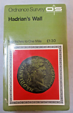 Vintage Retro Ordnance Survey Map - Hadrians Wall - 2 inch to 1 Mile Historical
-
$11.99
 Original 1888 Shire Map CUMBERLAND England Carlisle Penrith Caledonian Railway
-
$12.48
 Bartholomew's Survey Map of THE ENGLISH LAKES (c1950) Sheet 34, England, Cloth
-
$29.99
 1814 John Cary Road Map Cumberland Cumbria Keswick Carlisle Penrith England UK
-
$49.96
 CUMBERLAND CUMBRIA LAKE DISTRICT BY EMANUEL BOWEN c1720 GENUINE ANTIQUE MAP
-
$43.73
 KENDAL, CUMBRIA Town and Street Plan, Dawson Original antique map 1832
-
$43.71
 CUMBERLAND CUMBRIA c1787 BY JOHN SELLER AND FRANCIS GROSE GENUINE ANTIQUE MAP
-
$31.23
 Antique Folding Guide Map Keswick Lake District 1925 J Bartholomew 10" x 6.5"
-
$206.13
 OGILBY original antique road map, LANCASTER, KENDAL, CARLISLE, Plate 38, c.1675
-
$61.22
 ANTIQUE ADMIRALTY CHART. No. 1346. THE FIRTH of SOLWAY. 1890 Edition.
-
$61.22
 ANTIQUE ADMIRALTY CHART. No.1826. SOUTHPORT to CARLISLE . 1915 Edition.
-
$56.22
 TYNEMOUTH TINMOUTH TO CARLISLE BY JOHN OGILBY REDUCED BY THOMAS GARDNER c1719
-
$118.68
 English Lake District: antique geology map by John Ruthven, 1855
-
$35.00
 1830 Nathan Hale Map England Wales London Liverpool Oxford Cornwall Bristol UK
-
$16.39
 1895 Cumberland county map. Victorian. Carlisle, Whitehaven, Keswick.
-
$19.99
 ANTIQUE 1833 CUMBERLAND CUMBRIA COUNTY ENGLAND MAP CARLISLE ESKDALE LEATH SUPERB
-
$61.22
 VINTAGE ADMIRALTY CHART. No.1826. BURROW HEAD to LIVERPOOL . 1953 Edition.
-
$11.23
 Readyfold Coloured Touring Map, c1930 - JOHNSTON - Section 15, Lake district
-
$74.96
 Framed Saxton's Map of England & Wales 1579, British Library Board 1976, VGC
-
$18.73
 CUMBERLAND COCKERMOUTH YORK OXFORD BY PATERSON c1785 GENUINE ANTIQUE MAP
-
$24.97
 NORTHUMBERLAND NEWCASTLE CUMBERLAND BY PATERSON c1785 GENUINE ANTIQUE MAP
-
$49.96
 WESTMORELAND CUMBRIA BY THOMAS KITCHIN c1770 GENUINE ANTIQUE ENGRAVED MAP
-
$93.70
 Antique Map of North England by Petrus Bertius 1618
-
$49.96
 WESTMORLAND CUMBRIA BY JOHN ROCQUE c1769 GENUINE ANTIQUE ENGRAVED MAP
-
$18.86
 1898 Cumberland, Carlisle with northern Lakes large map. 125 years old. England.
-
$21.23
 Antique Map Of Westmoreland By Thomas Kitchin c1786
-
$34.98
 CUMBERLAND, CUMBRIA, Seller/Grose, Original Antique County Map c1780
-
$37.47
 Vintage Contoured Map The Lake District Cumbria Windermere CLOTH BACKED 1930s
-
$11.23
 Antique Map Dated 1955 On Cloth Barrow In Furness Ordnance Survey National Grid
-
$74.96
 Antique Map of Northern England by Von Reilly 1789
-
$36.19
 Vintage Map Lake District Keswick & Ullswater CLOTH BACKED c.1920s 1930s
-
$7.48
 Old Victorian Map Cumberland (Cumbria), England 1840 Pigot: Antique: Reprint
-
$24.99
 Vintage Lake District 3 x 2 maps Bartholomew & Ward locke & co Guide book
-
$31.23
 CUMBERLAND, CUMBRIA, George Gray, Original Hand Coloured Antique Map 1824
-
$12.48
 1818 Cumberland J Robins Antique Map Dugdale Carlisle Lake District Handcoloured
-
$34.98
 CUMBERLAND, CUMBRIA, Edward Weller Original Antique Map c1870
-
$49.96
 CUMBERLAND CUMBRIA BY THOMAS KITCHIN C1770 GENUINE COPPER ENGRAVED ANTIQUE MAP
-
$43.71
 CUMBERLAND CUMBRIA KENDAL KESWICK PENRITH BY JOHN CARY c1822 ANTIQUE MAP
-
$49.96
 WESTMORLAND CUMBRIA BY EMANUEL BOWEN c1720 GENUINE ANTIQUE ENGRAVED MAP
-
$49.96
 CUMBERLAND CUMBRIA KESWICK BY JOHN ROCQUE c1769 GENUINE COPPER ENGRAVED MAP
-
$17.49
 Grasmere, Ambleside, ENGLISH LAKES, Genuine Antique Map, c1898
-
$37.48
 Antique map of the North of England by SUDK 1831
-
$31.22
 1809 Antique Map; Westmorland, Cumbria, John Cary, New & Correct English Atlas
-
$9.98
 LAKE DISTRICT, CUMBRIA, WESTMORLAND - 1930 Antique Map by Bartholomew
-
$6.18
 Lake District Touring Map Sheet 3 1:63,360
-
$14.99
 Vintage 2 x Ordnance Survey Maps, Penrith & Keswick, Unused.
-
$54.97
 CUMBERLAND CUMBRIA James Pigot Original Hand Coloured Antique County Map c1830
-
$7.48
 Old Antique map Cumberland Cumbria England c1830's Moule: Reprint Carlisle View
-
$37.47
 WESTMORLAND CUMBRIA DISTANCE CHART MORDEN / VAN LANGEREN c1731 GENUINE ANTIQUE
-
$37.47
 WESTMORLAND CUMBRIA BY ROPER & COLE c1810 GENUINE ANTIQUE ENGRAVED MAP
-
$49.96
 WESTMORLAND CUMBRIA BY BADESLADE & TOMS c1742 GENUINE ANTIQUE WITH HAND COLOUR
-
$37.47
 WESTMORLAND CUMBRIA BY ROPER & COLE c1810 GENUINE ANTIQUE ENGRAVED MAP
-
$36.19
 Vintage Contoured Map Wharfedale Yorkshire CLOTH BACKED c.1920s 1930s
-
$11.23
 Vintage Roadmap - 30.5" X 40" - Cumbria, Fleetwood, Lancaster, Isle Of Man
-
$36.19
 Vintage Contoured Map Lake District Windermere & Ulverston CLOTH BACKED 1925
-
$62.45
 1794 Antique Map; City of Carlisle and Places Adjacent.
-
$15.62
 Crummock, Ennerdale, Lowes, ENGLISH LAKES, Genuine Antique Map, c1898
-
$19.99
 ENGLAND & WALES NW. Cumbria Lancashire Welsh coast Isle of Man. WELLER 1863 map
-
$18.73
 1884 County Map Cumberland Lake District Lett Popular Atlas Old Antique Vintage
-
$74.96
 Cumbria: antique map by Van den Keere, 1627-76
-
$32.48
 NORTH WEST ENGLAND. Lake District Isle of Man Cumbria Westmorland. SDUK 1874 map
-
$19.99
 England & Wales North. Yorkshire Lancashire Cumbria Lincs. THE TIMES 1895 map
-
$318.57
 CUMBRIA, WESTMORLAND, Saxton & Kip, Camden Original antique map 1637
-
$31.23
 WESTMORLAND, CUMBRIA, Capper Original Hand Coloured Antique County Map 1808
-
$16.24
 ENGLAND NW. Cumbria Westmorland. Inset Barrow in Furness;Isle of Man 1920 map
-
$14.99
 3 x Old Antique maps & views Westmorland (Cumbria) England 1600s 1800s Reprint
-
$12.48
 1840 Antique Map; Westmorland, Cumbria. Cole & Roper.
-
$43.73
 WESTMORELAND, CUMBRIA, Charles Smith Original Antique County Map c1830
-
$9.37
 7 x Maps Of North England Lake District Ordnance Survey & Others Job Lot Bundle
-
$37.47
 1795 Antique Map; Westmorland / Cumbria - John Lodge
-
$12.49
 Reproduction Historic map Pivot & Co’s of County Cumberland, 1840
-
$62.40
 c1830 Wales North West England Cumbria Mersey Cheshire Is. Man Antique Map Print
-
$8.75
 1835. KENDAL. MAP. TOWN PLAN. BY R CREIGHTON. GOOD CONDITION. WESTMORLAND
-
$19.99
 ENGLAND NORTH. Yorks, Westmorland, Lancs, Cumbria, Lincs 1903 old antique map
-
$6.87
 Bartholomew Lake District One Inch Map Vintage
-
$21.23
 ENGLAND.Cumbria.Lake district. London; Channel Islands. Jersey Guernsey 1897 map
-
$14.99
 1779. SOLWAY MOSS. CARLISLE LONGTOWN GRETNA. ANTIQUE MAP
-
$24.97
 The Lake District (c1930s) Vintage Ordnance Survey Folding Map, Cumbria, England
-
$32.48
 NORTH WEST ENGLAND. Lake District Isle of Man Cumbria Westmorland. SDUK 1845 map


