 Antiques (US)
-
$156.86

 NORTH ENGLAND, ISLE OF MAN, 'Regni Angliae' original antique map, De Wit, c.1680
-
$69.02
 ENGLAND, YORKSHIRE, LANCASHIRE, 'England nordlicher Theil', Von Reilly, c.1790
-
$69.02
 Original antique map, NORTHERN ENGLAND, YORKSHIRE, Von Reilly, c.1790
-
$31.37
 Antique map of Lancashire by John Seller and Francis Grose 1810
-
$87.84
 Antique Map of England and Wales by John Cary 1789
-
$56.47
 Antique map of Lancashire by Richard Blome 1715
-
$94.11
 Antique Map of North England by Petrus Bertius 1618
-
$62.74
 Antique map of Lancashire by Robert Morden 1720
-
$31.37
 BURY, LANCASHIRE, Tottington, Heywood, Holcombe, Whitefield, antique map 1868
-
$18.82
 Antique map of Lancashire by Thomas Moules 1842
-
$50.19
 Antique map of Lancashire by Alexander Hogg and Thomas Conder 1784
-
$31.37
 ISLE of MAN ANTIQUE MAP LEWIS TOPOGRAPHICAL c1850
-
$75.29
 Antique Map of Northern England by Von Reilly 1789
-
$94.11
 Antique map of Lancashire by Robert Morden 1695
-
$37.65
 Antique map of the North of England by SUDK 1831
-
$56.47
 Antique map of Lancashire by Henry Teesdale 1829
-
$18.82
 Antique map of Lancashire by William Lewis 1819
-
$56.47
 Antique map of Lancashire by John Seller 1701
-
$94.11
 Antique Map of Lancashire by John Cary 1789
-
$35.14
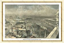 OLD BIRDS EYE VIEW MAP OF MANCHESTER 1876 - 30" x 20" PHOTOGRAPHIC PRINT
-
$30.12
OLD BIRDS EYE VIEW MAP OF MANCHESTER 1876 - 24" x 16" PHOTOGRAPHIC PRINT
-
$18.81
 LANCASHIRE - Georgian Map (1831) Lewis's Topographical Dictionary England County


