 Antiques (US)
-
$250.00

 Antique Hand Colored Map Alex Hogg A New & Correct Map of North Wales
-
$84.50
 Antique Map-OOSTENDE-OSTEND-BELGIUM-Guicciardini-1660
-
$58.00
 1956 Europe Map Topographical Elevations France Turkey Asia Yugoslavia Germany
-
$125.00
 Antique Hand Colored Map Isles Britannique
-
$200.00
 Rare Antique "New Map of England by John Senex" (Framed 29"x26")
-
$21.90
 1899 SOVIET EASTERN EUROPE Vintage Geographical Map Russia Soviet Original C11-9
-
$24.90
 1905 SWEDEN Vintage Map Norway Scandinavia ORIGINAL 11.5 x 9.5 Color C10-6
-
$21.99
 Old World Map of Europe 1600s Ancient Maps Vintage Style Poster Print
-
$24.90
 1890 ISTRIA Vintage Map Croatia Italy Island ORIGINAL 11.5 x 9.5 Color C10-6
-
$24.90
 1899 ROMANIA BULGARIA Vintage MAP Serbia Montenegro ORIG. 11.5 x 9.5 Color C10-7
-
$21.90
 1890 BATTLE OF METZ IN 1870 ORIGINAL VINTAGE MAP Liezpeg Germany C10-1
-
$24.90
 1906 - ST. PETERSBURG Russia Vintage Geography Map ORIGINAL 11.5 x 9.5" - C11-4
-
$24.90
 1897 SAXON DUCHIES Vintage MAP Germany Sachsen ORIG. 11.5 x 9.5 Color C10-7
-
$224.50
 Antique Map-GERMANY-RHINE-HEIDELBERG-Sanson-1674
-
$150.00
 Antique Hand Colored Map Scotland from the Best Authorities
-
$249.50
 Antique Map-France with provinces-Auvergne-Brittany-Normandy-Robbe-De Fer-1721
-
$24.90
 1928 - German Empire - Vintage Geography Map Europe ORIGINAL 11.5 x 9.5"- C11-9
-
$21.90
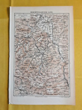 1901 ORIGINAL VINTAGE MAP Berchtesgade Bavaria Alpine County Germany C102
-
$30.63
 Bulgaria Color Lithograph Folding Map 1965 Russian Language Large Size & Booklet
-
$24.90
 1890 - Germany - Vintage Geography Map ORIGINAL 11.5 x 9.5"- C11-2
-
$105.68
 Antique Map of England by Petrus Bertius 1618
-
$24.90
 1890 European Vintage Map Karten Register I ORIGINAL 11.5 x 9.5 Color C10-6
-
$54.99
 LOT OF 3 ANTIQUE 1859 COLTON'S ATLAS HAND COLORED ENGRAVING MAP OF GERMANY
-
$43.52
 Antique map of Syria and Mesopotamia by Christoph Cellarius 1745
-
$24.90
 1900 BRANDENBURG Vintage Map Potsdam German ORIGINAL 11.5 x 9.5 Color C12
-
$32.90
 1898 Mediterranean Countries Vintage Geographical Map ORIGINAL 19 x 9.5" C12-6
-
$24.90
 1895 GREECE ARCIPELAGO ISLANDS Geographical Vintage Map ORIG. 11.5 x 9.5" C12-3
-
$34.99
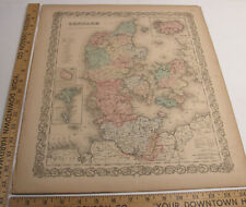 ANTIQUE 1859 COLTON'S ATLAS HAND COLORED ENGRAVING MAP DENMARK INSET OF ICELAND
-
$115.00
 Antique Hand Colored Map The Road From Carlisle to Rarwick
-
$249.50
 Antique Map-Scandinavian region-Norway-Finland-Sweden-North Cape-De Fer-1721
-
$714.50
 Antique Print-DENMARK-JUTLAND-Ortelius-1606
-
$67.50
 Antique Plan of Konstantinopel-Istanbul and Turkey-Konstantinopel-Meyers-1895
-
$18.64
 1875 Antique Map; General Faidherbe's Campaign 1870-71, Franco-Prussian War
-
$24.90
 1885 - Genoa Italy - Vintage Geography Map ORIGINAL 11.5 x 9.5" - C11
-
$24.90
 1895 - Copenhagen Denmark - Vintage Geography Map ORIGINAL 11.5 x 9.5" - C11-4
-
$40.00
 Beautiful Map-SWITZERLAND 1911 -SCHWEIZ-SUISSE Muir Way New Topographical
-
$50.00
 1824 Antique Map; Scotland by Anthony Finley
-
$24.90
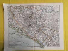 1895 BOSNIA MONTENEGRO Vintage Geographical MAP ORIG. 11.5 x 9.5 Color C12
-
$115.00
 Antique Hand Colored Map of Lincolnshire The Road From Nottingham to Grimsby
-
$252.95
 antique Map of Vogtlandiae (southern Germany) 18th century Paullo Longolio
-
$24.90
 1906 AUSTRO-HUNGARIAN Vintage Ethnographic Map ORIGINAL 11.5 x 9.5 Color C11-8
-
$491.12
 Antique Map of Florida, Georgia by Antonio Zatta and John Mitchell 1778
-
$21.90
 1890 ORIGINAL VINTAGE City MAP Danzig Poland C10-1
-
$42.99
 SOUTHERN ITALY NAPLES SICILY 1790 ORIGINAL HAND COLORED MAP DE VAUGONDY
-
$80.82
 Antique Map of Africa by Petrus Bertius 1672
-
$41.99
 1779 DETAILED TOPOGRAPHICAL MAP OF SYRIA & PHOENICIA, +Related Text
-
$167.85
 Antique Map of Great Britain by Christoph Weigel 1718
-
$24.90
 1887 - Copenhagen Denmark - Vintage Geography Map ORIGINAL 11.5 x 9.5" - C11-4
-
$24.90
 1887 - Copenhagen Denmark - Vintage Geography Map ORIGINAL 11.5 x 9.5" - C11
-
$49.73
 Antique map of Australasia and Polynesia by John Russell 1825
-
$24.90
 1894 BADEN Vintage Geography Map Germany Region ORIGINAL 11.5 x 9.5"- C12
-
$24.90
 1902 - Berlin Germany- Vintage Geography Map ORIGINAL 11.5 x 9.5"- C11-1
-
$41.99
 1783 DETAILED TOPOGRAPHICAL MAP OF OTTOMAN EMPIRE, Plus Area-Related Text
-
$45.00
 1844 1-page Atlas Map by Olney "BRITISH ISLES" including Ireland / Eire
-
$24.90
 1895 SICILY Vintage Map Italy Island German ORIGINAL 11.5 x 9.5 Color C10-6
-
$68.38
 Antique Map of the Adriatic coast by Petrus Bertius 1672
-
$34.99
 ANTIQUE 1859 COLTON'S ATLAS HAND COLORED ENGRAVING MAP AUSTRIA W/INSET OF VIENNA
-
$24.90
 1890 European Vintage Map Karten Register III ORIGINAL 11.5 x 9.5 Color C10-6
-
$38.90
 1924 POLAND Vintage Large Geographical Map ORIG. Italian 12.5 x 10.5" C13-1
-
$24.90
 1906 - ST. PETERSBURG Russia Vintage Geography Map ORIGINAL 11.5 x 9.5" - C13
-
$93.25
 Antique Map of Britain by Petrus Bertius 1618
-
$24.90
 1884 - Agriculture in Austria-Hungary - Vintage Map ORIGINAL 11.5 x 9.5"- C11-2
-
$24.90
 1899 SWEDEN NORWAY Vintage MAP South Scandinavia ORIG. 11.5 x 9.5 Color C10-7
-
$34.99
 ANTIQUE 1859 COLTON'S ATLAS HAND COLORED ENGRAVING MAP SPAIN & PORTUGAL
-
$38.90
 1905 WORLD MERCATOR Currents Vintage Large Map ORIG. Italian 12.5 x 10.5" C13-1
-
$24.90
 1912 FRANCE Vintage Map Paris Mediterranean Sea ORIGINAL 11.5 x 9.5 Color C10-8
-
$49.73
 Antique map of Northamptonshire by Richard Blome 1715
-
$19.99
 1901 Andrees Map Germany Thuringische Thuringia Frankfurt Gotha Weimar Halle
-
$24.90
 1912 FRANCE Vintage Map Paris Mediterranean Sea ORIGINAL 11.5 x 9.5 Color C12-4
-
$19.99
 Original 1897 Map LAKES OF KILLARNEY County Kerry Ireland Lough Leane Aghadoe
-
$12.42
 1826? England Wales Old Antique Map Cary? Published by George Virtue
-
$24.90
 1890 - Middle Europe - Vintage Geography Map ORIGINAL 11.5 x 9.5"- C11-2
-
$24.90
 1889 BELGIUM Vintage Geographical Map Europe German Original 10 x 9.5" COLOR C13
-
$34.99
 ANTIQUE 1859 COLTON'S ATLAS HAND COLORED ENGRAVING MAP OF HOLLAND & BELGIUM
-
$24.90
 1912 FRANCE Vintage Map Paris Mediterranean Sea ORIGINAL 11.5 x 9.5 Color C12
-
$34.99
 ANTIQUE 1859 COLTON'S ATLAS HAND COLORED ENGRAVING MAP SWEDEN & NORWAY
-
$24.90
 1885 - London United Kingdom - Vintage Geography Map ORIGINAL 11.5 x 9.5" - C11
-
$74.60
 Antique map, Road: Fontainbleau to Montargis. 1774, Guide Royal par L Denis
-
$24.90
 1885 - Konigsberg Germany - Vintage Map ORIGINAL 11.5 x 9.5"- C11-2
-
$24.90
 1928 - German Empire - Vintage Geography Map Europe ORIGINAL 11.5 x 9.5"- C11-3
-
$49.73
 Antique map of Herefordshire by Richard Blome 1715
-
$18.64
 1875 Antique Map; Siege of Saarbrücken 1870, Franco-Prussian War: Walker/Hozier
-
$24.90
 1895 BELGIUM LUXEMBOURG Vintage Map ORIGINAL 11.5 x 9.5 Color C12
-
$43.52
 Antique map of Europe, Asia and Africa by Christoph Cellarius 1745
-
$12.43
 EUROPE in the 9th CENTURY - 1907 Antique Historical Map - Mounted
-
$21.90
 1896 SALZKAMMERGUT Austria ORIGINAL VINTAGE MAP Region Alps Mountain Color C12-5
-
$24.90
 1900 BRANDENBURG Vintage Map Potsdam German ORIGINAL 11.5 x 9.5 Color C11-9
-
$21.90
 1900 SCOTLAND Vintage Map Edinburgh Skye Island German Original COLOR C10-9
-
$62.17
 Antique atlas frontispiece illustration by Philip Cluver 1672
-
$325.00
 Antique Henricus Hondius Map of Guyana Amazon Region, 1630s Hand Colored Framed
-
$80.82
 Antique Map of Greece by Petrus Bertius 1672
-
$24.90
 1897 GREECE ARCIPELAGO ISLANDS Geographical Vintage Map ORIG. 11.5 x 9.5" C12-3
-
$24.90
 1906 - ST. PETERSBURG Russia Vintage Geography Map ORIGINAL 11.5 x 9.5" C12-6
-
$22.44
 1934 MAP 6 x 9" (15 x 23 cm) - ATHENS & Environs Piraeus Eleusis Greece
-
$11.18
 Maps Of France 3 Avignon Montpellier Auvergne Pays Du Nord Picardie Tourist Maps
-
$24.90
 1894 AGRICULTURAL MAP GERMANY Vintage Geography Color ORIGINAL 11.5 x 9.5" C11-4
-
$45.00
 two-page 1844 historical School Atlas Map by Olney of the ROMAN EMPIRE
-
$99.47
 Antique map of Roman Britain by Robert Morden 1720
-
$192.50
 ANTIQUE MAP-LIMBURG-NETHERLANDS-BACHIENE-1758
-
$274.50
 Antique Print-HAARLEM-NETHERLANDS-Guicciardini-1613


