 Antiques (US)
Africa Maps
Asia Maps
Australia/Oceania Maps
Celestial Maps
Central America/Caribbean Maps
Curiosities Maps
Digital Maps
Europe Maps
Map & Globe Mixed Lots
Map & Globe Reproductions
North America Maps
South America Maps
World & Celestial Globes
World Maps

-
$299.99

 AUTHENTIC LARGE COLOR MAP FROM 18TH CENTURY - Museum Grade Quality
-
$700.00
 Original Antique Large Map of Africa by Guillaume Delisle, 1765
-
$62.50
 Chao Phraya River Thailand Siam Bangkok Menam River 1752 Bellin hand color map
-
$125.00
 Moscow Russia City Plan Fortifications Walls Farms 1719 Mallet city plan map
-
$39.99
 1774 Antique Old Colored Map Of L’Espagne Spain Portugal Land Europe
-
$450.00
 A Corrected Map of the United States of North America by T. Bowen 1784
-
$1.00
 Virginia Revolutionary War Map 1774 1783 Independence Bicentennial Commission
-
$600.00
 NORTH AMERICA CALIFORNIA AS AN ISLAND 1706 DE LA FEUILLE ANTIQUE MAP
-
$600.00
 RARE 1799 Early Map of State of South Carolina from Payne's Universal Geography
-
$600.00
 1807 Plan of the Siege of Charleston in South Carolina, SC Revolutionary War Map
-
$13.00
 1943 Vintage Map - Indian Land Cessions 1784-1798 - Kentucky - Ohio - Tennessee
-
$17.95
 1700s New World Spanish Colonies Old Map - 20x28
-
$23.95
 1771 Early American 13 Colonies - East Coast Map - 24x28
-
$197.50
 Africa continent c. 1750 Sanson engraved hand color map
-
$97.50
 Corsica & Sardinia Roman Empire 1711 Senex engraved hand color map
-
$57.50
 Eastern Ottoman Empire Anatolia Syria Holy Land Armenia 1772 decorative HC map
-
$45.00
 1750 Hand-Colored Map of Europe by Robert De Vaugondy
-
$49.00
 Ancient World Holy Land Middle East Anatolia Armenia Mesopotamia c. 1720 map
-
$9.99
 6x7 Print Of 1777 West Indies Map Mounted On Cardboard
-
$40.00
 Oyster and Huntington Bays 1778 Published by an Act of Parliament Repro.
-
$56.21
 SPAIN AND PORTUGAL BY ROBERT DE VAUGONDY c1794 GENUINE ANTIQUE ENGRAVED MAP
-
$225.00
 1787 PF Tardieu Ohio River Tributary Maps Muskingum Beaver Sioto Indian Villages
-
$16.95
North America 1771 Colonial Map - 13 Colonies - 20x24
-
$200.00
 Rare Antique "New Map of England by John Senex" (Framed 29"x26")
-
$34.00
 Avesnes France Pas-de-Calais Fortified City c. 1710 engraved city plan map
-
$19.98
 OLD ANTIQUE ROAD MAP NOTTINGHAM NEWARK LINCOLN GRIMSBY by OWEN & BOWEN c1740s
-
$31.21
 YORKSHIRE YORK LINCOLN NOTTINGHAM NEWARK STAMFORD ROAD MAP BY JOHN SENEX c1757
-
$13.95
 1720 Old World Exploration Map Historic Print - 16x24
-
$302.50
 1744 Georg Mattaus Seutter Antique Map of Europe
-
$112.50
 Duchy of Dauphine Kingdom France Provence Savoy Piedmont 1708 de la Feuille map
-
$312.25
 1728 VERY RARE Herman Moll Map , Genuine Antique, Voyage Of Aeneas Greece
-
$187.50
 Siamese Capital Thailand Ayutthaya 1752 French detailed city plan hand color map
-
$12.95
 1796 PENNSYLVANIA CYRUS HARRIS MAP MANY OLD TOWN NAMES WITH LONG “S”(f) PRINTING
-
$4.95
 Original 1797 George Kearsley Color Map Sweden Norway Denmark Finland Lapland
-
$20.00
 1760 Gentleman's Magazine - Map of Kassel - Jamaica Uprising - Cherokee Battles
-
$16.95
 Historic Map of New England 1747 Vintage Style Colonial Map - 20x24
-
$24.97
 LANCASHIRE LANCASTER CUMBRIA KENDAL BY EMANUEL BOWEN c1720 GENUINE ANTIQUE MAP
-
$13.95
 1770s Early Map of Connecticut, New Jersey, New York & Long Island - 16x20
-
$97.50
 Africa Interior Nile River Mountains of the Moon prominent 1768 Toms color map
-
$87.72
 A Map Of Darby Shire by Robert Morden 1753 Metal Framed Engraved Map
-
$100.00
 Antique map of the world by Tho Bowen 1778
-
$15.00
 Vintage Longmans Map of The Netherlands in 1702
-
$76.89
 Antique Syria Phoenicia Saudi Arabia Map Mesopotamia Persia c. 1700s
-
$16.95
 1747 Map of the Gulf Coast - Louisiana to Florida - 20x24
-
$24.98
 OLD ANTIQUE MAP LEICESTERSHIRE by OWEN & BOWEN c1740 18c ENGRAVING
-
$67.49
 1846 RARE ORIGINAL MAP TEXAS REPUBLIC UNITED STATES NEW YORK FLORIDA MICHIGAN
-
$37.46
 NORTHAMPTONSHIRE BY SELLER / GROSE c1787 GENUINE ANTIQUE ENGRAVED MAP
-
$18.95
 Dublin Ireland Vintage Irish City Map - 20x30
-
$225.00
 An Accurate Map of North America with the New Discoveries 1799 D. Ogilby Wow!!
-
$42.50
 West African Coast South Africa Congo Table Bay 1746 Bellin lovely coastal map
-
$13.00
 1943 Vintage Map - British Florida 1763-1783 - St. Augustine Alabama, Louisiana
-
$49.99
 Original 1788 Bowen Map GERMANY AUSTRIA POLAND Berlin Vienna Warsaw Prussia Bonn
-
$40.00
 1756 "The London Magazine" - Kitchin Map of Anglesey - Christopher Wren -Minorca
-
$27.49
 1877 RARE ORIGINAL ENGRAVING UNITED STATES WASHINGTON, D.C. CAPITOL panorama
-
$9.99
 Vintage Map "Spain and Portugal" & "A Map of the mouth of the River Tagus" 1756
-
$26.95
 1790s Historic World Map of the Discoveries of Captain Cook - 24x42
-
$395.00
 The State of New York Samuel Lewis Mathew Carey 1795 Antique Engraved Map
-
$49.00
 Holy Roman Empire Germany Austria Low Countries c.1749 Senex hand color map
-
$42.50
 Mughal India Roadways Infrastructure Calcutta Lucknow Madras c. 1795 Fraser map
-
$25.00
 View of Lisboa Portugal - Original Print Mallet - 1718
-
$13.95
 Carolina 1732 Interesting Old Historic Map - 18x24
-
$4.95
 Original 1797 George Kearsley Color Map Italy Sicily Corsica Italia Venice
-
$181.11
 Framed 17TH C Hand Coloured John Oligby Strip Map Bristol to Banbury Plate 55
-
$17.95
1732 Carolina Historic Old American Map - 20x28
-
$9.95
 Original 1797 George Kearsley Color Map Hindoostan India Ceylon South Asia
-
$47.20
 Historic Map Groton Conn 1655-1799 Town Owner Names Genealogy Date Unknown
-
$70.00
 Eighteenth Century Hand-Col. Map of London & Environs, 1787 - PRICE REDUCED
-
$93.68
 EUROPE EUROPA BY NICOLAS SANSON c1794 GENUINE COPPER ENGRAVED MAP
-
$16.95
 1750s L' Amerique Septentrionale New World Map - 20x24
-
$49.00
 Ottoman Empire Balkans Greece Serbia Romania Croatia 1744 Senex hand color map
-
$14.99
 antique print 1750 Robert Benard Direxit Encyclopedia Astronomy France
-
$72.50
 Kingdom of Scotland Edinburgh Glasgow Shetland UK 1770's Kitchin hand color map
-
$85.00
 Map Bonne, Les isles Philippines celle de Formose, le sud de la Chine 1780
-
$19.99
 Spain and Portugal antique map 1795 by William Guthrie
-
$74.94
 London The TOWER Liberty. Original engraving by Blome ca 1720
-
$325.00
 1735 Hand-Colored Map of Caspian Sea and Region, Maas / Homann, Uzbek, Iran etc.
-
$80.00
 1796 Blondeau Map World North America Africa Europe Asia Australia South America
-
$17.95
 Map of the Republic of Ireland 1700s - 20x28
-
$75.00
 1780 BONNE UNUSUAL ANTIQUE ORIGINAL WORLD MAP ON MERCATOR'S PROJECTION
-
$19.90
 1881 ORIGINAL ANTIQUE MAP OF THE NORTHERN SKY ASTRONOMY CONSTELLATIONS ZODIAC
-
$2800.00
 Original Sectional Case Map 1746: D'Anville: Amerique Septentrionale Insular CA
-
$13.95
1750s Early North America New World Exploration Map - 16x20
-
$23.95
1740s Map of the New Orleans and the Gulf Coast - 24x30
-
$24.00
 St. Croix Danish Reproduction Map of 1767 Caribbean Plantation, Paul Kuffner
-
$50.00
 Antique maps, Bonne, Le nord de l'Europe .. Danemark, La Norwege, la Suede 1780
-
$80.00
 MEXICO - PARTIE MERIDIONALE DE L' ANCIEN MEXIQUE BY RIGOBERT BONNE, CIRCA 1780.
-
$49.00
 Camaret Bay Brest Brittany British Military Disaster c.1740-50 Basire battle map
-
$43.70
 LONDON ABINGDON GLOUCESTERSHIRE ROAD MAP BY JOHN SENEX c1762 ORIGINAL ANTIQUE
-
$16.95
 1700s “Map of the World” Remarkable Vintage Style Map - 20x24
-
$13.95
1740s Early Map of the Gulf Coast - Texas, Louisiana, Florida - 16x20
-
$195.00
 An Correct Map of the World with the Latest Discoveries 1799 Original Look!!!
-
$99.00
 18th Century Map of Massachusetts W. Barker Sculpt.
-
$175.00
 Antique 1784 Nautical Chart Cook Inlet Prince William Sound Alaska Original Map
-
$20.95
1799 Old World Map Poster - The Sailing Routes of Capt Cook - 20x36
-
$49.00
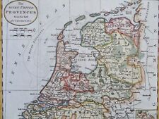 Seven United Provinces Low Countries Netherlands Holland Friesland c. 1790 map
-
$13.95
 1700s “Map of New France” Vintage Style Early United States Map - 16x20
-
$9.99
 American Revolutionary War Washington's March to Yorktown New Jersey Virginia
-
$49.00
 Russian Empire Muscovy Novgorod Perm Siberia Kamchatka Poland c. 1780 Bonne map
-
$82.50
 Acapulco Mexico Coastal Survey Star Fort 1754 engraved hand color map
-
$112.50
 Lopburi Thailand Louvo Chao Phraya River 1752 Bellin hand color city plan


